The Year 1961—Blacksburg High School Leads County in Desegregation

In 1961, Blacksburg High School became the first in Montgomery County to admit African American students, paving the way for full integration of all county high schools by 1966.

Montgomery County, Virginia, was slow to dismantle enforced racial separation in its schools, not doing so until September 1961. Neighboring counties followed a similar pace—Floyd in January 1961 and Pulaski in September 1961. (Martin, Black Education in Montgomery County 1939–1966, Virginia Tech master’s thesis, 1996).

After the U.S. Supreme Court’s 1954 Brown v. Board of Education ruling outlawed segregation, Montgomery County resisted. The school board leaned on “states’ rights” arguments and used tactics from Virginia’s Gray Commission—such as controlling student assignments and offering tuition grants to white families—to delay integration for years.

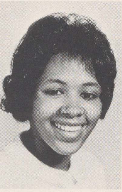
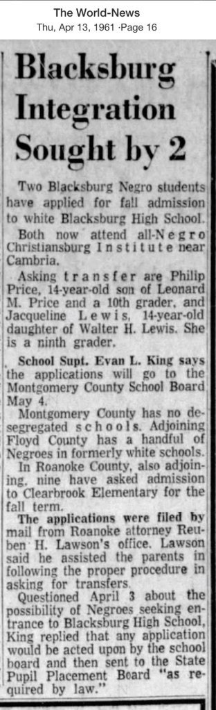
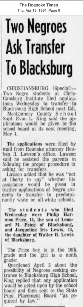
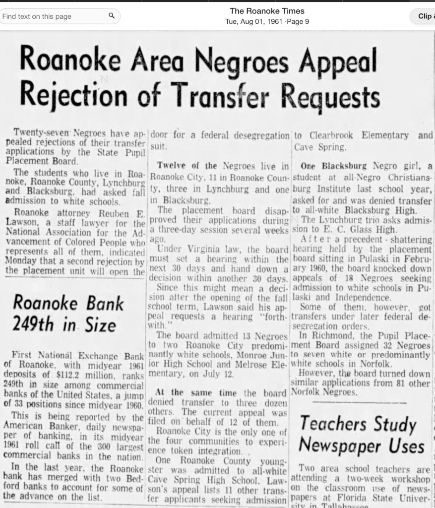
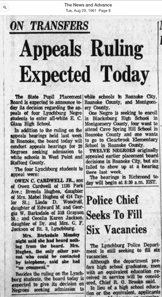
Amidst this resistance, three students from Christiansburg Institute applied to transfer to the all-white Blacksburg High School, which then enrolled about 900 students. They were siblings Phillip H. Price (15) and Ann Christine Price (13), along with Jacqueline Iris Lewis (14). With support from NAACP attorney Reuben E. Lawson of Roanoke, their applications went before the State Pupil Placement Board. Phillip and Ann Christine were admitted for the 1961 school year, but Jacqueline’s request was denied on the grounds of “academic standards”—a requirement never applied to white students.

On August 23, 1961, Jacqueline and her father, Walter H. Lewis, traveled to Roanoke for the hearing, an intimidating experience for a 14-year-old. The Board delayed its ruling for a week before denying her appeal. That fall, Jacqueline remained at Christiansburg Institute.

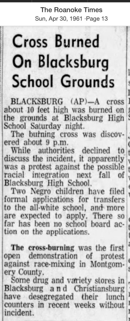
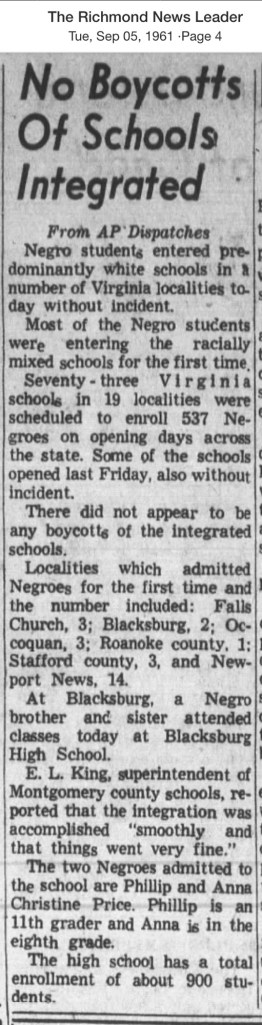
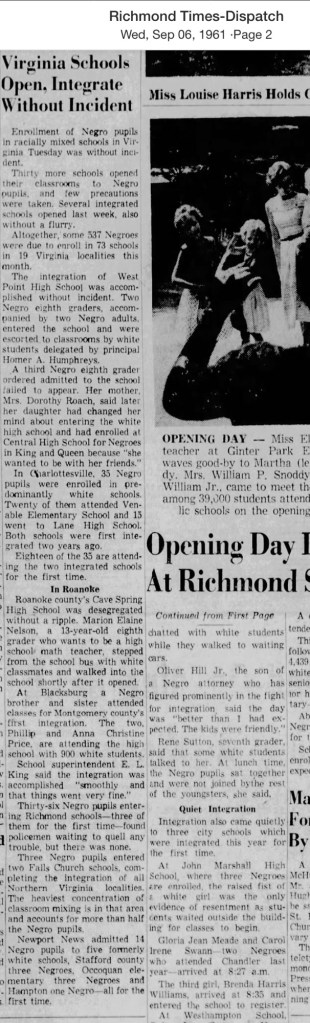
That September, Phillip and Ann Christine Price became the first Black students to integrate Montgomery County schools when they walked into Blacksburg High. According to researcher Tracy A. Martin, they were not alone—their white neighbors walked beside them in solidarity. This act of courage followed a chilling warning: on April 29, 1961, a ten-foot burning cross had been discovered on the school grounds, South Main Street.

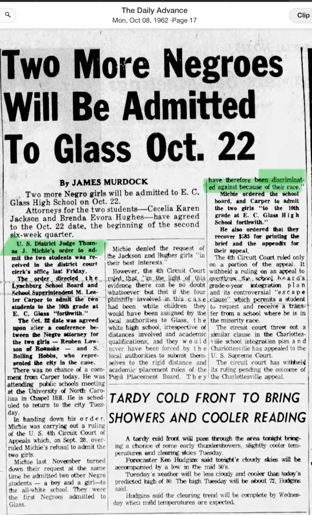
In 1962, the school board again delayed the application process for two more students seeking admission. Yearbooks from 1961–1964 suggest that the Price siblings were the only African American students at Blacksburg High during those early years. In the years that followed, more students of color began to appear in the yearbooks. By 1966, the school board closed Christiansburg Institute, and all of the county’s white high schools were finally opened to every student.

Newspaper Articles

April 1961

July 1961

August 1961

September 1961

1962 Application of Two Young Women, the Courts Ruling

Montgomery County Resources

Montgomery County, Virginia Resources and the Formation of the County Over Time

National Register of Historic Places Application – 1989

National Register of Historic Places Application – 1989

This searchable document is a rich source of information about the county and its wider connections. For example, it notes that the New River boatmen once lived on Kent Farm, where they were enslaved by James Randle and Margaret Cloyd Kent prior to emancipation (see page 13). Additional details about Kentland and these freedmen can be found in the following postings: Historic Kentland and Historic Wake Forest

The names of some of the black boatmen of 19th-century Montgomery County include Frank Bannister (who was a boatman on the James River before the Civil War), Calvin Bannister, Roland Stuart, George Brown, and Lewis Smith.


Montgomery County Reconnaissance Level Survey, 1986

This report that was written by Gibson Worsham, Dan Pezzoni, Charlotte Worsham, David Roenizer, and others. It addresses the following: 1) Overview of the county’s history, 2) A comprehensive inventory of significant structures and sites in the county and 3) Maps delineating the location of said structures and sites. Similar to the report above, this is a wealth of information about the county.


More information can be found on this website: Gatherings Blacksburg History


The Formation of Montgomery County, Virginia and Why it Matters to African American History of the Region

When Virginia’s earliest European colonial settlers first pushed westward beyond the Blue Ridge Mountains, they entered the border lands already inhabited by Native peoples for thousands of years. As Europeans laid claim to these territories in the 18th century, Virginia’s county boundaries began shifting rapidly to keep pace and the need for local governance.

At first, all of western Virginia was considered part of vast counties based far to the east. Augusta County, created in 1738, stretched from the Blue Ridge to the Mississippi River—a landmass so large it was nearly impossible to govern effectively. As settlement expanded, Augusta was gradually carved into smaller counties.

Botetourt County was created in 1770 out of Augusta, and just two years later, in 1772, Fincastle County was formed to cover the far southwest. But Fincastle itself was short-lived: in 1776, it was split into three new counties—Montgomery, Washington, and Kentucky (the latter eventually becoming the Commonwealth of Kentucky).

Thus, Montgomery County was officially established in 1776, named in honor of General Richard Montgomery, a Revolutionary War hero.

Like most early counties, Montgomery did not remain the same size for long. As population grew and communities demanded closer courts and local representation, Montgomery’s original boundaries were gradually reduced.

  • 1790: Wythe County was formed from Montgomery.
  • 1790: Parts of Montgomery contributed to the creation of Kanawha County (now in West Virginia).
  • 1806: Giles County was carved from Montgomery, Monroe, Wythe, and Tazewell.
  • 1831: Montgomery giving land to Floyd
  • 1839: Montgomery giving land to Pulaski
  • 1892: City of Radford

By the mid-19th century, Montgomery County had taken on the approximate shape we recognize today.

Why This Matters

Tracing these changing boundaries shows how the western border lands of Virginia evolved from a vast Indigenous landscape into the network of counties we know today. When we study Montgomery County’s formation and its changing borders, we are not only tracking political geography—we’re also uncovering how those shifts shaped the daily realities of enslaved people and freedmen. The “line on a map” often meant the difference between where families were recorded, where they could live, and how they could begin to claim freedom and opportunity.

County seats like Christiansburg were not only centers of trade and government but also of the slave market and the courthouse records that tracked the lives of enslaved people. After emancipation, those same courts became the places where freedmen registered marriages, secured contracts, and sought land. As county lines shifted, so too did the jurisdictions that controlled access to justice, opportunity, and community life.

The flip book of maps below is a helpful resource to understand how the boundaries changed with time. Begin on page 395.

Virginia Atlas of Historical County Boundaries

Pulaski County Resource

Pulaski County Reconnaissance Survey, created by Gibson Worsham, Dan Pezzoni, and many others, is such a valuable resource. It provides vital insights into African American history in Southwest Virginia and the greater Central Appalachian region, helping us better understand the interconnected stories that shaped our communities.

Montgomery County, Virginia, has never existed in isolation.

The people who have lived here—whether by choice, through enslavement or servitude, or as Indigenous communities who established towns long before European arrival—moved across boundaries freely. They traveled, traded, fought, buried their dead, and carried out the everyday work of survival across what later became county lines.

This is why the Pulaski County Reconnaissance Survey, created by Gibson Worsham, Dan Pezzoni, and many others, is such a valuable resource. It provides vital insights into African American history in Southwest Virginia and the greater Central Appalachian region, helping us better understand the interconnected stories that shaped our communities.

This report is fully searchable and contains valuable early documentation on African American schools, churches, and communities. It also includes a generalized map that highlights both early European settlements and land tracts. For example, Dunkard’s Bottom—now submerged beneath Claytor Lake—was once part of an early German settlement.

The report also identifies significant Scotch-Irish tracts such as Draper Valley/Peak Mountain, Harrison, Robinson, Springfield, and Thorn Spring. It notes the communities of Newbern and New Dublin, along with the region’s main transportation routes: Traders Path/Leadmine Road, the Great Road/Wilderness Road/Southwestern Turnpike, Peppers Ferry Road, and the Dublin/Giles Turnpike.

The report offers a clear explanation of the early Importation and Treasury Rights system used to claim land (see pages 23–24). For further detail, see F.B. Kegley, Kegley’s Virginia Frontier, Roanoke, VA: Southwest Virginia Historical Society, 1938. p. 59.

Read the full Pulaski County Reconnaissance Survey report ›

By Gibson Worsham, Dan Pezzoni, Leslie Naranjo-Lupoid, Joseph T Koelbel, Dan Rotenizer, Charlotte Worsham, Vicky Goad, CA Cooper-Ruska

Pulaski County Reconnaissance Level Survey Document, 1985 by Gibson Worsham, Dan Pezzoni and others.

The report contains interesting data about the enslaved, noted on page 44. Also, the churches and New River Village is discussed beginning on page 56.

In Pulaski the pattern of large landholding influenced the ownership of slaves. Whereas in Montgomery County there were 2,219 slaves, and in Pulaski only 1,589 in 1859, eight slaveholders had more than fifty slaves in Pulaski while only two landowners in Montgomery possessed as many. In both counties, however, the majority of owners possessed ten or fewer slaves. During the Civil War, the Confederacy began requisitioning slaves to work in the war effort. At the beginning of the war many slaves were requisitioned and shipped to Richmond to fortify the state capital. In the following three years slaves were requisitioned four times so that by 1865 the county found it could no longer comply as it was being drained of free and slave manpower, food supplies and money.

Map of Pulaski County noting the mines, more importantly the African American village of “New River”

Pulaski Timeline

Timeline was created for the 2030 Comprehensive Plan of Pulaski County

A Note on the Language in the County’s Comprehensive Plan

As part of Montgomery County’s 30-year Comprehensive Plan, a historical timeline was created. While the dates provided are generally accurate, the language used to describe Indigenous people and borderlands does not align with our values.

We want our readers to be aware that these depictions reflect the language of the plan’s authors—not the values or beliefs of this website. Our commitment is to present history in a way that acknowledges the dignity, presence, and contributions of all people who have lived in this region.

Note that the African American community of “New River” came to exist after emancipation.

Pulaski Newspapers

Virginia Tech Collection

Nellie’s Cave Community: The Demise of a Historic Black Neighborhood

https://hub.catalogit.app/8896/folder/entry/98929bc0-ef3a-11ed-a57e-bf9a788efd8b

Southeast of the Town of Blacksburg, on the eastern side of the Allegheny Mountains, a community of African American families took root in the early 20th century when the Mills family purchased 40 acres from the Hoge family. For generations, these families farmed the land, raised children, and built their lives in this secluded karst landscape. The unpaved lane that served them was not called Nellie’s Cave Road until the 1980s, when Montgomery County officially named it. Before then, the residents knew it simply as Grissom Lane. The old farm road began at the Slusher family’s farm—located at the southeast corner of South Main Street and Country Club Drive—and ended where the terrain became too steep for a wagon to pass.

More to be posted …

The Merry Tree

The Merry Tree, now a broken and weathered stump southeast of the Preston home, once stood as a silent witness to over a century of enslavement. It remains a sacred place where descendants return to honor their ancestors. We are gathering stories, photos, and memories connected to this tree. Let’s preserve its powerful legacy.

Help Us Tell the Story of the Merry Tree

For over a century, the Merry Tree stood as a silent witness to the lives of the 226 people enslaved by the Preston family at Smithfield, Blacksburg, Virginia. Planted near the time the Prestons built their home, this tree bore witness to generations of forced labor, family separation, resistance, and endurance. Though now reduced to a broken and weathered stump, the Merry Tree remains a place of deep meaning—especially for the descendants of those once enslaved, who return here to remember, honor, and reflect.

We are seeking to gather as much information, memory, and meaning as possible about this special tree. Did your family speak of it? Do you have photos, stories, or oral history connected to the Merry Tree? Whether you are a descendant, community member, or researcher, your voice matters in helping us preserve and understand the role this sacred place played in Black history in Montgomery County.

Please share what you know. Together, we can ensure the story of the Merry Tree—and those who stood beneath it—is never forgotten.

#MerryTree #BlackHistory #SmithfieldVoices #CommunityMemory #TruthTelling

https://themerrytree.vt.domains

https://news.vt.edu/articles/2022/03/unirel-merryoak.html

https://youtu.be/MRtNTU6f5Ao?si=M82B2-3mk2GNea19

https://fb.watch/Al2YW58dry/?fs=e

https://fb.watch/Al2_CTJG-s/?fs=e

https://news.vt.edu/videos/k/2024/08/1_tznvjyyu.html

https://www.wfxrtv.com/news/local-news/new-river-valley-local-news/merry-oak-tree-brings-dozens-together-to-remember-enslaved-families/

https://historicsmithfield.wordpress.com/2017/02/28/merry-oak/?fbclid=IwQ0xDSwLCMlZleHRuA2FlbQIxMQABHv0vjeN0Bf21sot8c_kdCGs34nl7HL1kqw3D79M5olBaYuk-obb_VAJ2ggBQ_aem_hTV02h4a8q1x_cCGxX_nBA

https://montcova.com/2024/08/02/historic-smithfield-dedicates-merry-oak-bench/

https://www.wvtf.org/news/2025-06-19/juneteenth-event-honors-226-people-who-were-enslaved-at-smithfield-plantation

https://virginiahumanities.org/events/2022/03/1872-forward-vt/

https://virginiahumanities.org/2022/08/more-than-a-fraction-the-power-of-the-merry-tree/

https://morethanafraction.com/uploads/1/3/2/3/132308734/drkmoseleyhobbs_cp.pdf

Witness Tree – Sycamore Guarding the Spring

This enormous sycamore stands just east of the spring that once provided potable water for the people living on the Smithfield property. The spring lies a considerable distance from the house and closer to the old Merry Oak. One can only imagine the countless gallons of water enslaved people carried from that spring to the white house on the knoll over nearly a century. Like the Merry Tree, this sycamore may have held significance for the men, women, and children forced to labor here—its presence a silent witness to their daily lives.

Genealogy of Slavery – Center for Studying Stricture of Race – Roanoke College

This website serves as an important resource for understanding the history and legacy of slavery in our region. It contains information collected from Roanoke County sources about more than 4,000 enslaved individuals.

https://www.roanoke.edu/a-z/center_for_studying_structures_of_race/projects_x71825

Genealogy of Slavery – Center for Studying Stricture of Race – Roanoke College

This website serves as an important resource for understanding the history and legacy of slavery in our region. It contains information collected from Roanoke County sources about more than 4,000 enslaved individuals. Many of the family names of enslaved African Americans recorded here also appear in neighboring Montgomery County, making this work deeply relevant to our local history. In addition, the family names of many individuals who enslaved others are found in the Roanoke primary sources.

The purpose of this page is to document and connect these shared names, with the hope of bringing to light the lives of those too often lost to history and deepening our understanding of the enduring legacy of slavery in Montgomery County and beyond.

More names will be added with time.

Family Names of Enslaved African Americans in Montgomery County

Brown

  • William Brown – enslaved by William Watts. “In IAS Book 4, the partition of the lands and other property of Edward Watts, William Brown is listed among the enslaved individuals that were bequeathed to Edward Watts’s daughter, Alice W. Morris. A value of $1,700.00 was placed on William Brown.”; Inventory, Appraisements, and Sales Book 4, Roanoke County Archives.

Calloway

Campbell

  • George Campbell – “George Campbell was listed in an indenture agreement: “…bind unto the said Lewis Zirkle a boy of colour named George Campbell until he arrives to the free age of twenty one which will be on the 25th day of June 1854.”
    In the Common Law book, it was ordered that the Overseers of the Poor bind out George, “a boy of color,” to Lewis Zinkle.”;
    Common Law Orders – A – May 1838 – May 1840, Roanoke County Archives.

Saunders/Sanders

Family Names of Enslavers in Montgomery County

Evans

  • Elizabeth Evans (List of first names of people they enslaved), “Elizabeth was listed in Michael Shepard’s property appraisement as having purchased enslaved people after Michael’s death. In the record, Elizabeth purchase” the enslaved people Joe, Nancy, and an unrecorded named child for $675.00.” She was possible daughter of Jonathan Evans. “Elizabeth’s son was William Evans and her husband was William W. Evans.”; Common Law Orders – B – June 1840 – July 1843, Roanoke County Archives

Kent

Kyle

Oliver

Wyatts

Genealogical Importance of Southern Confederacy Documents for African American Research

When researching African American genealogy, particularly in the South, it can be challenging to trace family history due to the lack of comprehensive records. However, some of this information can be found in an unexpected place: the Civil War documents of the Southern Confederacy and the United States Military.

When researching African American genealogy, particularly in the South, it can be challenging to trace family history due to the lack of comprehensive records. However, some of this information can be found in an unexpected place: the Civil War documents of the Southern Confederacy and the US Military.

The book Virginia’s Black Confederates: Essays and Rosters by Greg Eanes highlights this, providing primary source documents that list the roles free and enslaved Black men, women, and children performed for the Southern war complex. These records, while written from a perspective that upholds the Confederacy’s narrative, contain valuable data for tracing African American ancestry.

The information in the post is found within this book. Eanes, Greg. Virginia’s Black Confederates: Essays and Rosters 2014. Civil War Sesquicentennial Edition, 2nd Edition.

Virginia 11th Regiment and Montgomery County

This regiment was established in Lynchburg, VA in May 1861 and put into service in July that same year. It was comprised of men from Botetourt, Campbell, Culpeper, Fauquier, Montgomery, and Rockbridge Counties. The free and un-free Blacks associated with this regiment may be listed in the regimental documents.

Eane’s Compilation of of Jobs Performed by Free & Enslaved (pgs 22-23)

  • Body Servant – “Assist with care, cleanliness, and order as assigned quarters, uniforms, and military personal equipment; Help to purchase, prepare, and serve food and beverages in the General Officer’s quarters.”
  • Cook – “Preparation and service of food in field or garrison food service operations.”
  • Teamster – “Motor Transport Operators” and “Cargo Specialist.”
  • Laborer-Breastwork – “Combat Engineer” and “Carpentry and Masonry Specialist.”
  • Laborer – Railroad – “Railway Equipment Repairers”, “Railway Section Repairers”, and “Railway Operations Crewmember.”
  • Laborer – Burial Details – “…recovery, collection, evacuation, establishment of tentative identification” of the body and possessions.
  • Hostler – “comprehensive care for government owned animals.”
  • Hospital Steward/Nurse – provide movement and care for injured people.
  • Musician – professional Army band
  • Blacksmith – “fabrication, repair and modification of metallic and nonmetallic parts.”
  • Mechanic – “maintenance and repair on artillery, small arms; store ammunition.”
  • Carpenter – “Perform general heavy carpentry, structural steel and masonry duties.”
  • Boatman – “..navigation, cargo operations and supervising other Soldiers on Army watercraft.”
  • Laundress – “supervising and performing laundry…”
  • Preacher – “Support Unit Ministry Team”
  • Scouts/Spies – “..reconnaissance…”

Compiled Service Records

Service records provide valuable information. They are available in paid sources, Ancestry.com or Fold.com and in Familysearch.org.

John Lavender Service Record, US Colored Troops, enlisted 15 Dec 1883. Blacksburg Resident after 1974.

Pension Applications of the Confederacy and US Military

Confederate Pension Acts for Virginia were enacted between 1888 and 1934. On 14 of March, 1924 the act centered on servants granted pensions. “The 1928 Act broadened recognized duties to include performance of guard duty, burring Confederate dead, working in railroad shops, blacksmith shops or hospitals” (Page 26).

The pension records can be found at the Library of Virginia and on Ancestry.com (subscription required).

National Archive article on how to use the Pension Records, “Union Pension Files Giving Voice to Former Slaves”

The 1910 (see image) and 1930 (CW) census indicates that the person was a veteran. The National Archives provides a helpful list of codes that were used.


Confederate Soldiers’ Home Application for Admissions Records

Found in the Library of Virginia digital collection or this link .


The American Civil War Museum

The archives of the museum maintain a large holding, some of which is digitized.

Confederate Certificate of Service – Freemen and Enslaved.

According to Eanes on page 113, the Army of the Confederate States adopted (1861) Form #4, the Certificate of Service. This was used for both free and unfree persons. Where these are located? We have not found an online source, yet.

Public laws of the Confederate States of America, first Congress, 1862-1864 / [edited by James M. Matthews].

Primary source of the Acts of the Confederate Congress, Public laws of the Confederate States of America, first Congress, 1862-1864 / [edited by James M. Matthews]

Chapter XXIX – An Act for the payment of musicians in the Army no regularly enlisted.” Page 29 (book, not pdf)
Chapter LXIV – An Act for the enlistment of Cooks in the Army”. Page 48 (book, not pdf)
“Chapter LXXIX – An Act to increase the efficiency of the Army by employment of free negroes and slaves in certain capacities” Page 235-236 (book, not pdf)

Reconstruction Era Documents and Freedmen Bureau Timeline

The Index of census returns, registers, and lists of freedmen is overseen by the Bureau of Refugees, Freedmen, and Abandoned Lands, commonly known as the Freedmen’s Bureau. Established in 1865 after the American Civil War, its responsibilities include supervising relief efforts such as education, healthcare, food, clothing, refugee camps, marriage legalization, employment, labor contracts, and ensuring back pay, bounty payments, and pensions.

Family Search records are free but registration is required.

United States Freedmen’s Bureau, Records of Freedmen – FamilySearch Historical Records

What is available:

  • Virginia, Roll 130, Registers of freedmen sent to New England states, 1866-1867
  • Virginia, Wytheville, Roll 198, Census returns of the black population of Montgomery, Grayson, Smyth, Giles, Roanoke, Craig, and Floyd Counties, 1865 (Images 214-412)
  • Virginia, Christianburg, Roll 68, Census returns of blacks in Montgomery County

Transcription Abbreviations

The transcription project is done by the public and not complete.

Click here to search on a name

History of the Freedman’s Bureau, official title: The Bureau of Refugees, Freedmen, and Abandoned Lands

A helpful explanation and timeline is provided on page 9 of this document, hosted by Family Search. “Records of the Field Offices for the State of Virginia.”

https://www.familysearch.org/ark:/61903/3:1:S3HT-DWR3-MLN?view=index&action=view

Seven Year Timeline of the Bureau of Refugees, Freedmen, and Abandoned Lands (Freedmen’s Bureau): March 1865 to June 1872.

September 2, 1862: “President Lincoln issued the Preliminary Emancipation Proclamation, declaring that as of January 1, 1863 “all persons held as slaves within any State, or designated part of a State, the people whereof shall then be in rebellion against the United States shall be then, thenceforward, and forever free.”” (Library of Congress)

January 1, 1863: President Lincoln issued the Emancipation Proclamation

April 9, 1865: Lee surrenders to Grant at Appomattox, ending the Civil War.

Juneteenth, 1865 – Smithsonian’s National Museum of African American of History & Culture

  • National – 3 March 1865: the bureau was created by the War Department of the US Government. Commissioners and Assistant Commissioners as well as General Superintendent of Schools were established.
  • Virginia – June 1865 to May 1866: Orlando Brown established an office and operated as Commissioner of Virginia, in Richmond.
  • Virginia – 4 July 1865 to 14 April 1867: Virginia Bureau is organized into 10 districts with an Agent/Superintendent in charge.
  • Mont. Co – Sept 1865: Buel Carter became the 8th District’s first Superintendent, establishing an office in Christiansburg but move the office to Wythville in September of the same year.
  • National – Oct 1865 to Jan 1867: Rev. John W. Alvord became Inspector of Finances and Schools to address schools.
  • Mont. Co – May 1866: Capt Charles S. Schaeffer arrives in Christiansburg as the agent, working under Brevet Maj. George P. Sherwood became Superintendent of the 8th District in June 1866.
  • Virginia – May 1866 to Aug 1866: Maj. Gen. Alfred H. Terry is Assistant Commissioner, Richmond.
  • National – 16 July 1866: the Bureau of Freedmen is extended by Congress.
  • Virginia – Aug 1866 to March 1867: Maj. Gen. John M. Schofield is named Assistant Commissioner .
  • Virginia – 15 April 1867: The state is reorganization into 10 Sub-districts with Sub-Assistant Commissioner in charge.
  • Mont. Co- 15 April 1867: District 8 , the central office remained in Wythville. CA Schaeffer remained in Christiansburg.
  • Virginia – March 1867 to May 1869: Orlando Bowen becomes Assistant Commissioner and Superintendent of Education.
  • National – 6 July 1968: The Bureau of Freedmen is extended for the last time.
  • National – 25 July 1868: Congress removes the Bureau’s Assistant Commissioners from the states, but claim agents remain in place.
  • Mont. Co. – Dec 1868: Freedmen’s Bureau closes its Christiansburg office. Schaeffer retained as Assistant Superintendent of Education.
  • Virginia – 1 Jan 1869: the 10 Virginia districts are reorganized into 8 Education Sub Districts and Assistant Superintendent of Schools are appointed.
  • Virginia – 1870: New constitution was ratified which included Public School Funding for all children as a requirement. By 1870 the legislation was set to allow this to happen, though the education would be segregated.
  • National- Summer 1870: Superintendents of Education removed and headquarters staff reduced.
  • National – 30 June 1872: The Freedmen’s Bureau was terminated by Congress.

Primary Source Series: Congress Investigates KKK 1872

In 1872, a 13-volume compilation of reports and testimonies, including those from previously enslaved individuals, documented a Congressional committee’s investigation into the Ku Klux Klan and other insurrectionary movements in the former Confederate states.

Report of the Joint Select Committee to Inquire into the Condition of Affairs in the Late Insurrectionary States by United States. Congress. Joint Select Committee on the Condition of Affairs in the Late Insurrectionary States

In 1872, a 13-volume compilation of reports and testimonies, including those from previously enslaved individuals, documented a Congressional committee’s investigation into the Ku Klux Klan and other insurrectionary movements in the former Confederate states.

While Virginia is absent from this congressional report, the testimonies offer valuable insights into the beliefs, attitudes, misconceptions, and misdirections surrounding the mistreatment of newly freed people residing in the former Confederate states.

Montgomery County (Va.) Cohabitation Register

Montgomery County (Va.) Cohabitation Register. This register records the name of the husband, his age, place of birth, residence, occupation, last owner, last owner’s residence, name of the wife, her age, place of birth, residence, last owner, last owner’s residence, name of children with the ages of each, and the date of commencement of cohabitation. Of note is the wide range of localities reported as the former slaves’ places of birth

Montgomery County (Va.) Register of Colored Persons Cohabiting Together as Husband and Wife, 1866 Feb. 27. N.p., 1866. Print

This document is very valuable and now that it has been digitized it is accessible. Please read the description and historical note by the Library of Virginia: (accessed 3 March 2024)

Direct Link to the pages as images and as a transcription

Montgomery County, Va Register of Colored Persons Cohabiting Together as Husband & Wife, 1866 Feb. 27 – citation and supporting information.

Description
Montgomery County (Va.) Register of Colored Persons of Montgomery County, State of Virginia, cohabiting together as Husband and Wife on 27th February 1866. Also commonly called Montgomery County (Va.) Cohabitation Register. This register records the name of the husband, his age, place of birth, residence, occupation, last owner, last owner’s residence, name of the wife, her age, place of birth, residence, last owner, last owner’s residence, name of children with the ages of each, and the date of commencement of cohabitation. Of note is the wide range of localities reported as the former slaves’ places of birth

Montgomery County (Va.) Register of Colored Persons Cohabiting Together as Husband and Wife, 1866 Feb. 27. N.p., 1866. Print.

Historical Note
 Note

Montgomery County was named for Richard Montgomery, who was killed in the American assault on Quebec late in 1775. It was formed from Fincastle County in 1776. Part of Botetourt County was added in 1789, and part of Pulaski County was added in 1842.

The Virginia legislature passed an act on 27 February 1866 to legalize the marriages of former slaves who had been cohabiting as of that date. See Virginia Acts of Assembly, 1866-1867, Chapter 18, An act to amend and re-enact the 14th section of chapter 108 of the Code of Virginia for 1860, in regard to registers of marriage; and to legalize the marriages of colored persons now cohabiting as husband and wife.

The federal Bureau of Refugees, Freedmen, and Abandoned Lands directed the Assistant Superintendents of the states to order the county clerks to make a registry of such cohabiting couples. See Circular No. 11, dated 19 March 1866, in Orders, Circulars, Circular Letters, and Letters of Instruction, vol. 2 (1866). Bureau of Refugees, Freedmen, and Abandoned Lands, Records of the Assistant Commissioner for the State of Virginia, 1865-1869. Miscellaneous reel 3880, Library of Virginia. National Archives microfilm M1048 (reel 41), Record Group 105.

Montgomery County (Va.) Register of Colored Persons Cohabiting Together as Husband and Wife, 1866 Feb. 27. N.p., 1866. Print.