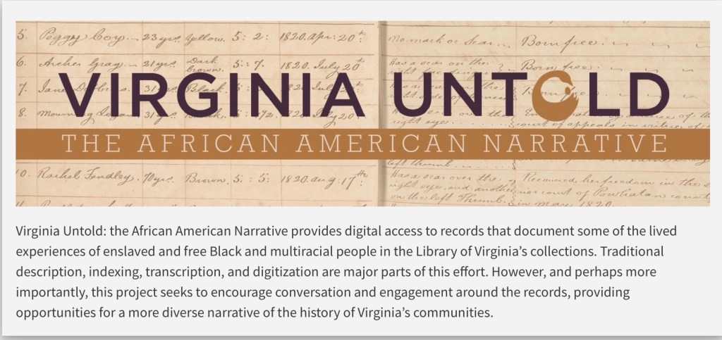
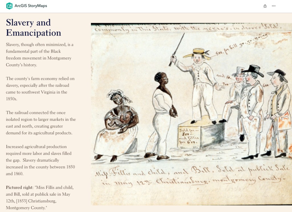
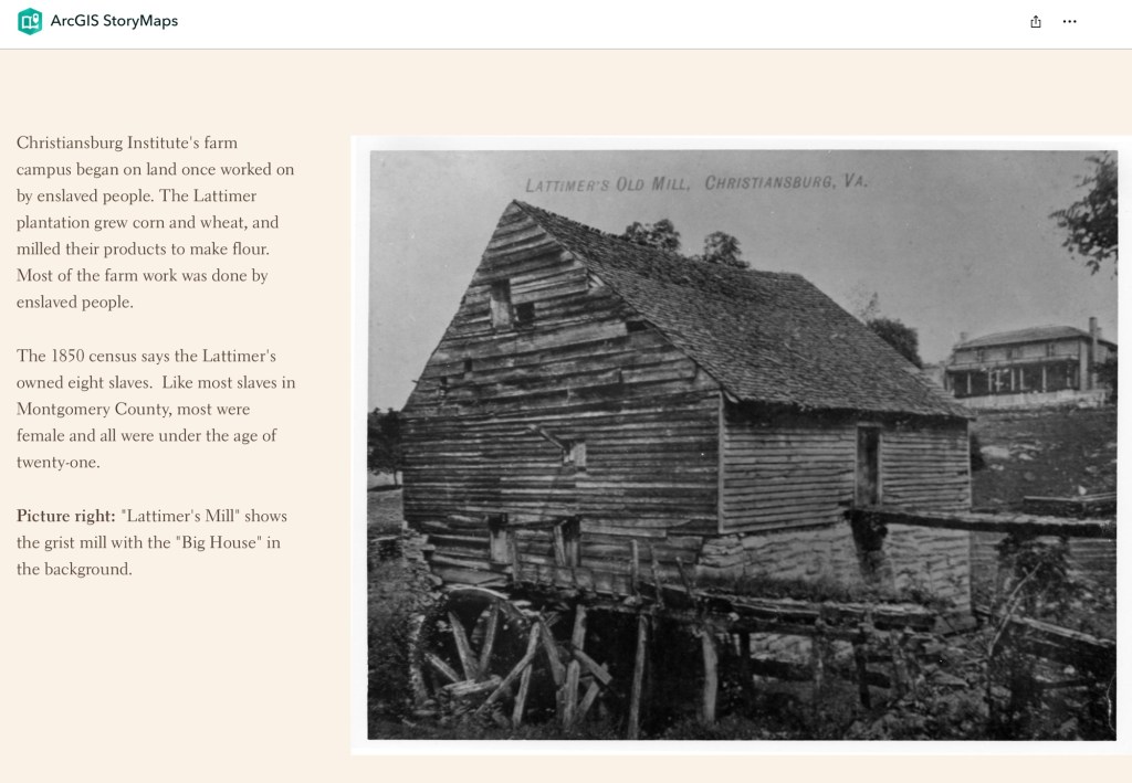
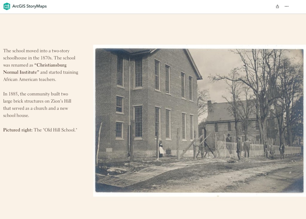
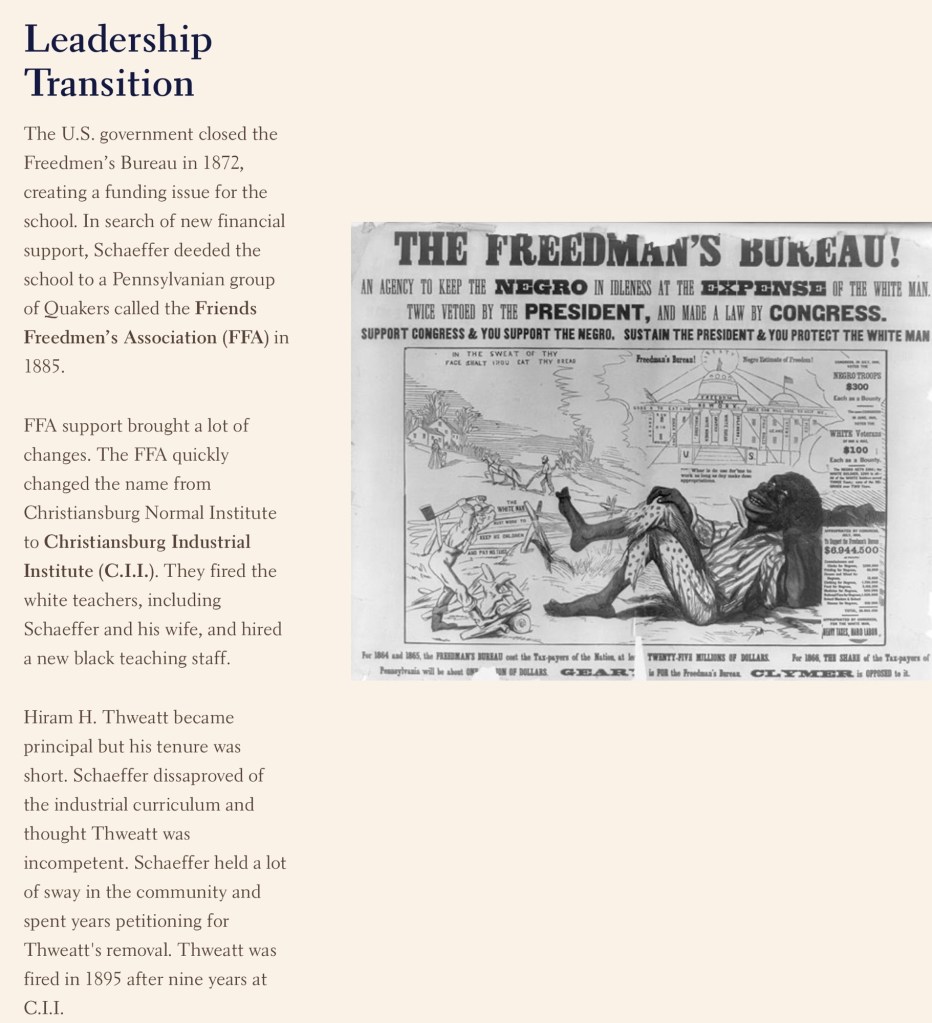
Virginia Untold offers a rich online archive of African American history. Search Montgomery and Wythe County records, and use downloadable PDFs for more precise, in-document searching.
Library of Virginia’s Virginia Untold: The African American Narrative provides a comprehensive online archive of African American and related history. These primary sources are invaluable for researchers and genealogists. Search “Montgomery County, VA” to locate local materials, and include “Wythe County, VA,” as some Montgomery County records are held there.
While the site offers search functionality, downloading the PDF transcriptions allows for more targeted searching. For example, a name search will return relevant documents, but locating specific references within them requires opening the PDF and using your browser’s search function. Please note that name spellings may vary.
Don’t forget to scroll down the Virginia Untold Search page for additional online resources. Also, the Library holds a huge collection of other online resources that is growing.
This searchable document is a rich source of information about the county and its wider connections. For example, it notes that the New River boatmen once lived on Kent Farm, where they were enslaved by James Randle and Margaret Cloyd Kent prior to emancipation (see page 13). Additional details about Kentland and these freedmen can be found in the following postings: Historic Kentland and Historic Wake Forest
The names of some of the black boatmen of 19th-century Montgomery County include Frank Bannister (who was a boatman on the James River before the Civil War), Calvin Bannister, Roland Stuart, George Brown, and Lewis Smith.
This report that was written by Gibson Worsham, Dan Pezzoni, Charlotte Worsham, David Roenizer, and others. It addresses the following: 1) Overview of the county’s history, 2) A comprehensive inventory of significant structures and sites in the county and 3) Maps delineating the location of said structures and sites. Similar to the report above, this is a wealth of information about the county.
The Formation of Montgomery County, Virginia and Why it Matters to African American History of the Region
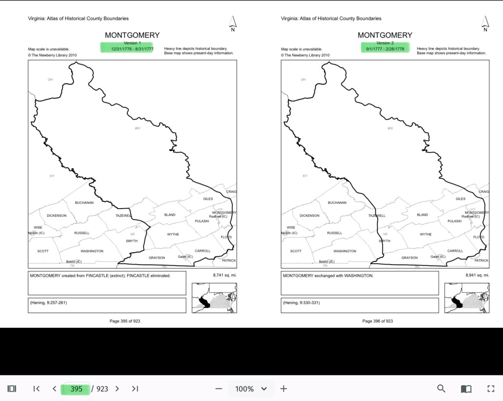
When Virginia’s earliest European colonial settlers first pushed westward beyond the Blue Ridge Mountains, they entered the border lands already inhabited by Native peoples for thousands of years. As Europeans laid claim to these territories in the 18th century, Virginia’s county boundaries began shifting rapidly to keep pace and the need for local governance.
At first, all of western Virginia was considered part of vast counties based far to the east. Augusta County, created in 1738, stretched from the Blue Ridge to the Mississippi River—a landmass so large it was nearly impossible to govern effectively. As settlement expanded, Augusta was gradually carved into smaller counties.
Botetourt County was created in 1770 out of Augusta, and just two years later, in 1772, Fincastle County was formed to cover the far southwest. But Fincastle itself was short-lived: in 1776, it was split into three new counties—Montgomery, Washington, and Kentucky (the latter eventually becoming the Commonwealth of Kentucky).
Thus, Montgomery County was officially established in 1776, named in honor of General Richard Montgomery, a Revolutionary War hero.
Like most early counties, Montgomery did not remain the same size for long. As population grew and communities demanded closer courts and local representation, Montgomery’s original boundaries were gradually reduced.
1790: Wythe County was formed from Montgomery.
1790: Parts of Montgomery contributed to the creation of Kanawha County (now in West Virginia).
1806: Giles County was carved from Montgomery, Monroe, Wythe, and Tazewell.
1831: Montgomery giving land to Floyd
1839: Montgomery giving land to Pulaski
1892: City of Radford
By the mid-19th century, Montgomery County had taken on the approximate shape we recognize today.
Why This Matters
Tracing these changing boundaries shows how the western border lands of Virginia evolved from a vast Indigenous landscape into the network of counties we know today. When we study Montgomery County’s formation and its changing borders, we are not only tracking political geography—we’re also uncovering how those shifts shaped the daily realities of enslaved people and freedmen. The “line on a map” often meant the difference between where families were recorded, where they could live, and how they could begin to claim freedom and opportunity.
County seats like Christiansburg were not only centers of trade and government but also of the slave market and the courthouse records that tracked the lives of enslaved people. After emancipation, those same courts became the places where freedmen registered marriages, secured contracts, and sought land. As county lines shifted, so too did the jurisdictions that controlled access to justice, opportunity, and community life.
The flip book of maps below is a helpful resource to understand how the boundaries changed with time. Begin on page 395.
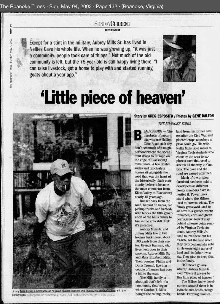
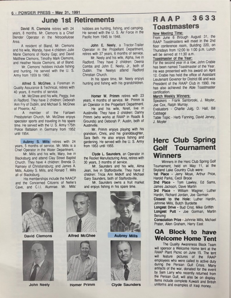
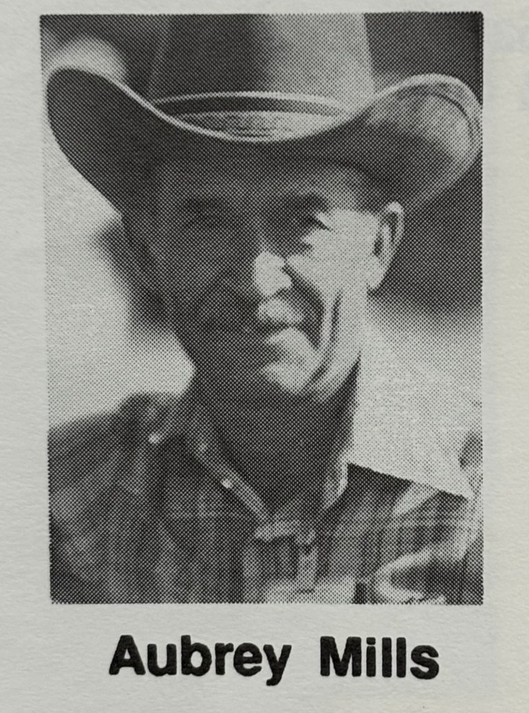
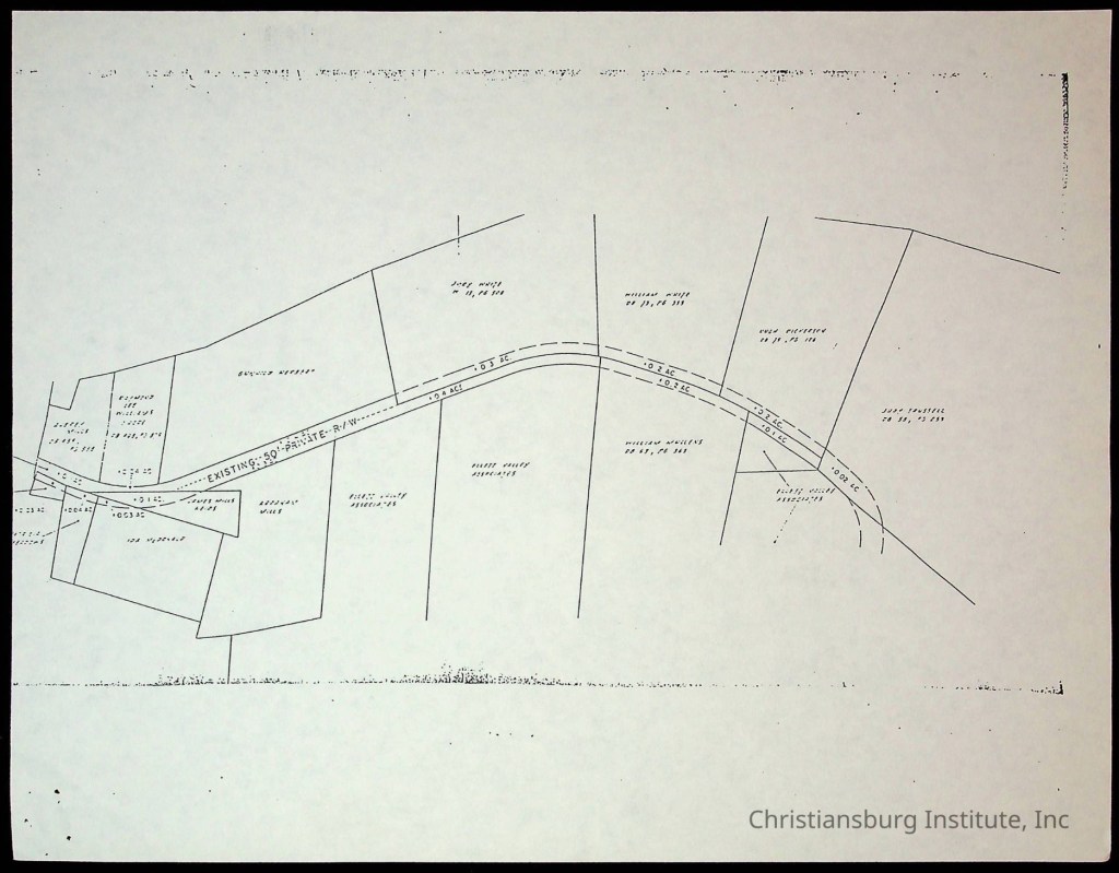
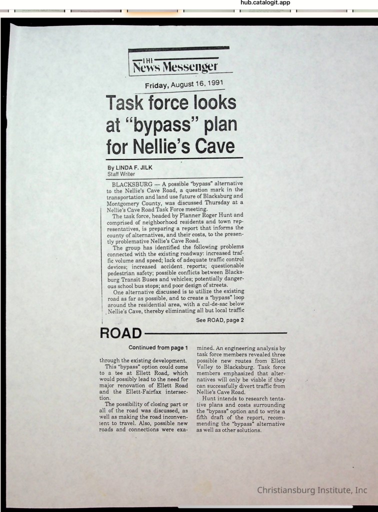
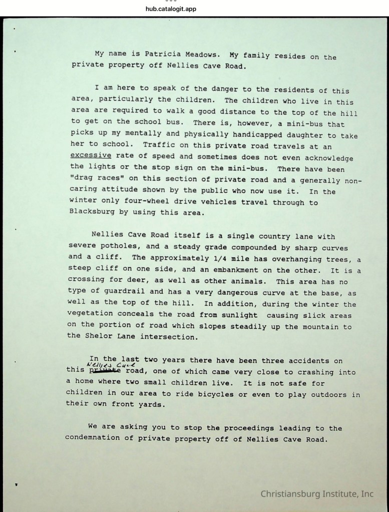
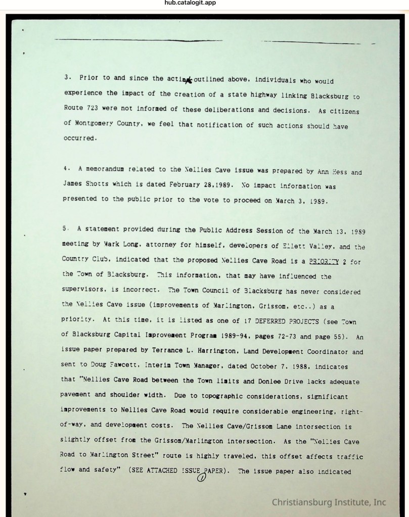
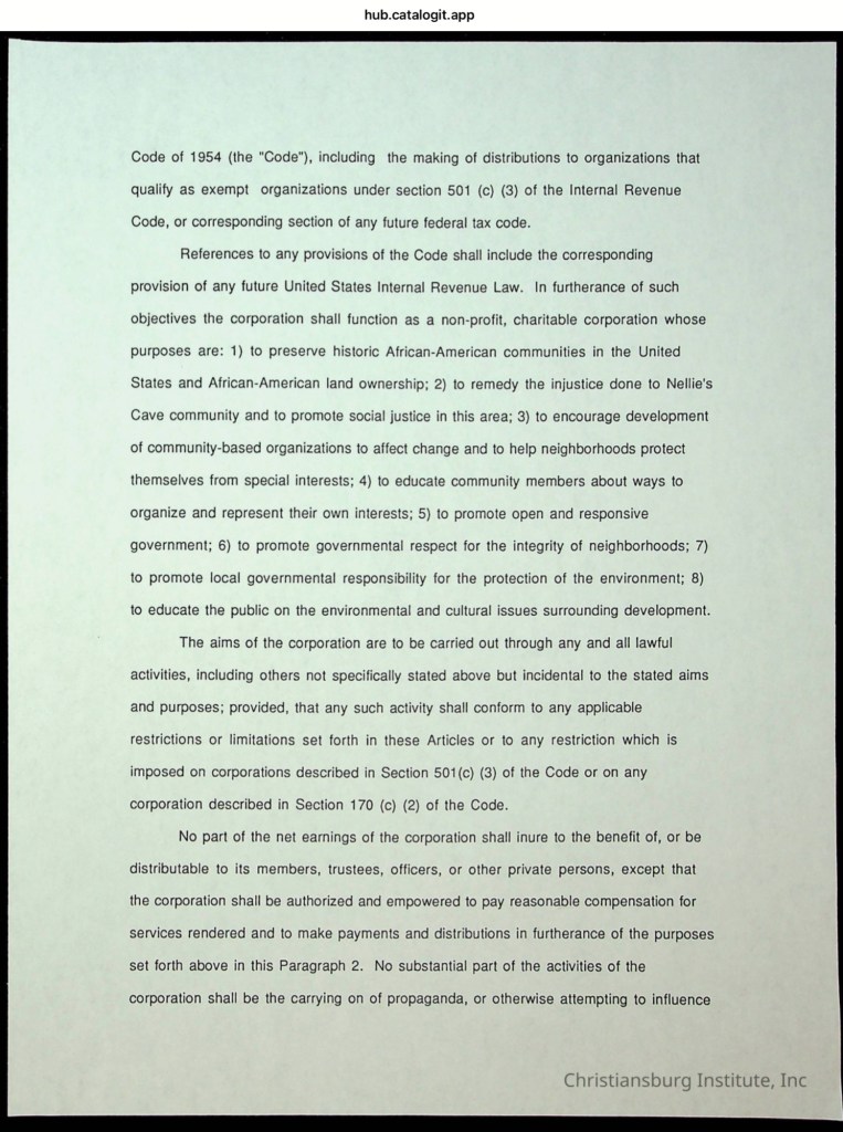
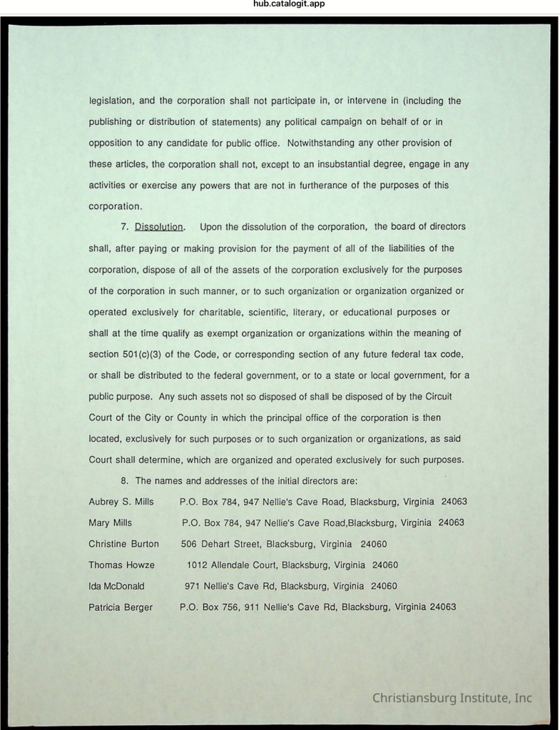
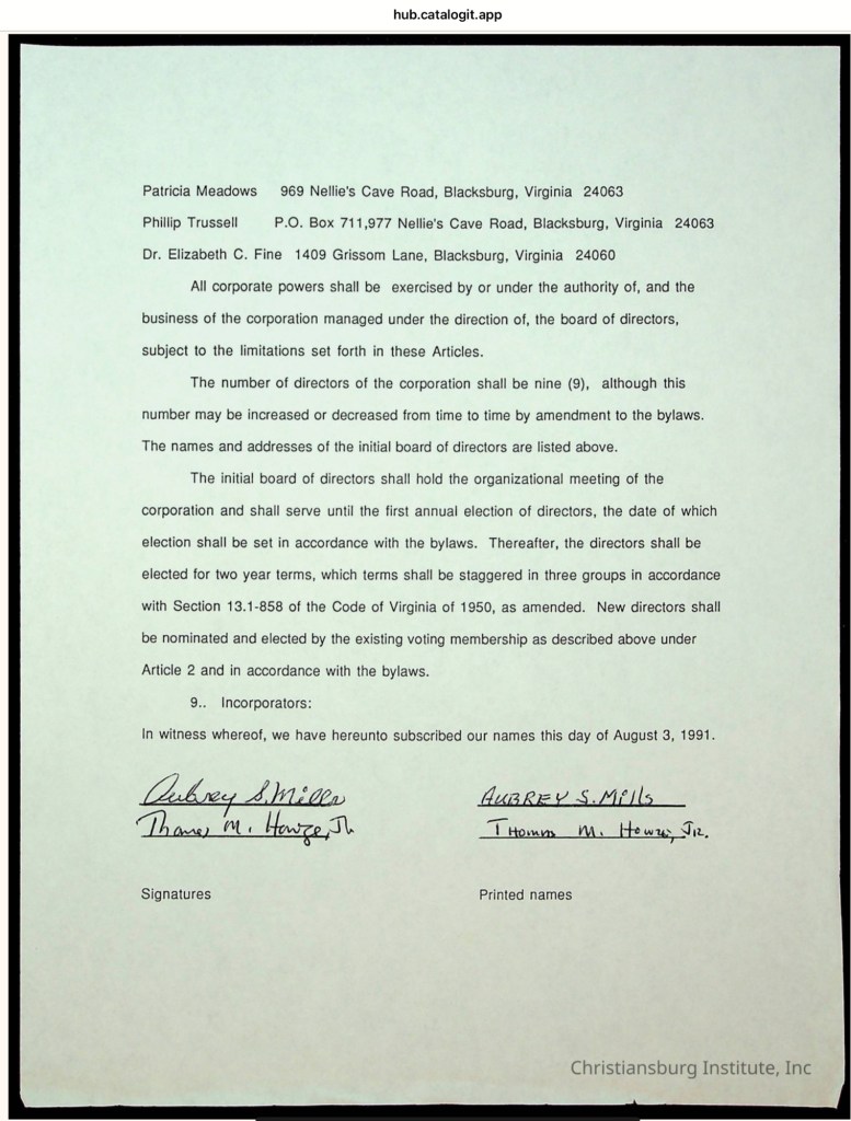
Southeast of the Town of Blacksburg, on the eastern side of the Allegheny Mountains, a community of African American families took root in the early 20th century when the Mills family purchased 40 acres from the Hoge family. For generations, these families farmed the land, raised children, and built their lives in this secluded karst landscape. The unpaved lane that served them was not called Nellie’s Cave Road until the 1980s, when Montgomery County officially named it. Before then, the residents knew it simply as Grissom Lane. The old farm road began at the Slusher family’s farm—located at the southeast corner of South Main Street and Country Club Drive—and ended where the terrain became too steep for a wagon to pass.
This digital exhibit is a thoughtfully crafted visual timeline highlighting the school’s key milestones and the individuals who shaped its legacy. This work honors the strength, resilience, and vision of the Black community in Montgomery County during the Reconstruction era and beyond.
This digital exhibit was curated by Demiah Smith, who thoughtfully crafted a visual timeline highlighting the school’s key milestones and the individuals who shaped its legacy. Her work honors the strength, resilience, and vision of the Black community in Montgomery County during the Reconstruction era and beyond.
To ensure the preservation of this work—especially after Christiansburg Institute, Inc. lost critical funding from the Institute of Museum and Library Services and the National Endowment for the Humanities—we’ve captured and archived the Story Map as images. This way, Demiah’s contribution and the vital story of CI will remain accessible even as the organization faces serious challenges due to the loss of federal support during the DOGE-era funding cuts.
We remain committed to uplifting and preserving this history. Stay tuned as we continue to find ways to support the legacy of the Christiansburg Institute and the people who made it possible.
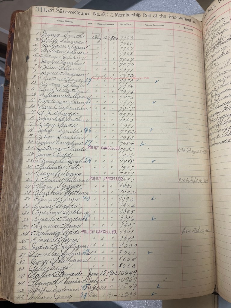
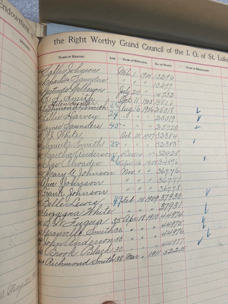
On August 4, 1902, Maggie Lena Walker herself founded the St. Frances Council #235, a significant event as she typically delegated the establishment of local Councils in the Independent Order of St. Luke to others.
St Luke, Odd Fellows & Household of Ruth Hall, 203 Gilbert St, Blacksburg, Virginia (Courtesy of Jody Daniels)Badge from the Blacksburg St Frances #235 Council (Courtesy of BMCF)
Maggie L. Walker National Historic Site Connection
The Maggie L. Walker National Historic Site, located in the Jackson Ward neighborhood of Richmond, is owned and operated by the National Park Service. Its archives house a wealth of information, much of which has yet to be digitized or made available online.
On August 4, 1902, Maggie Lena Walker herself founded the St. Frances Council #235, a significant event as she typically delegated the establishment of local Councils in the Independent Order of St. Luke to others. This raises the question: did she visit Blacksburg personally to work with the African American community there? While we currently lack direct documentation to confirm this, there are intriguing connections to consider.
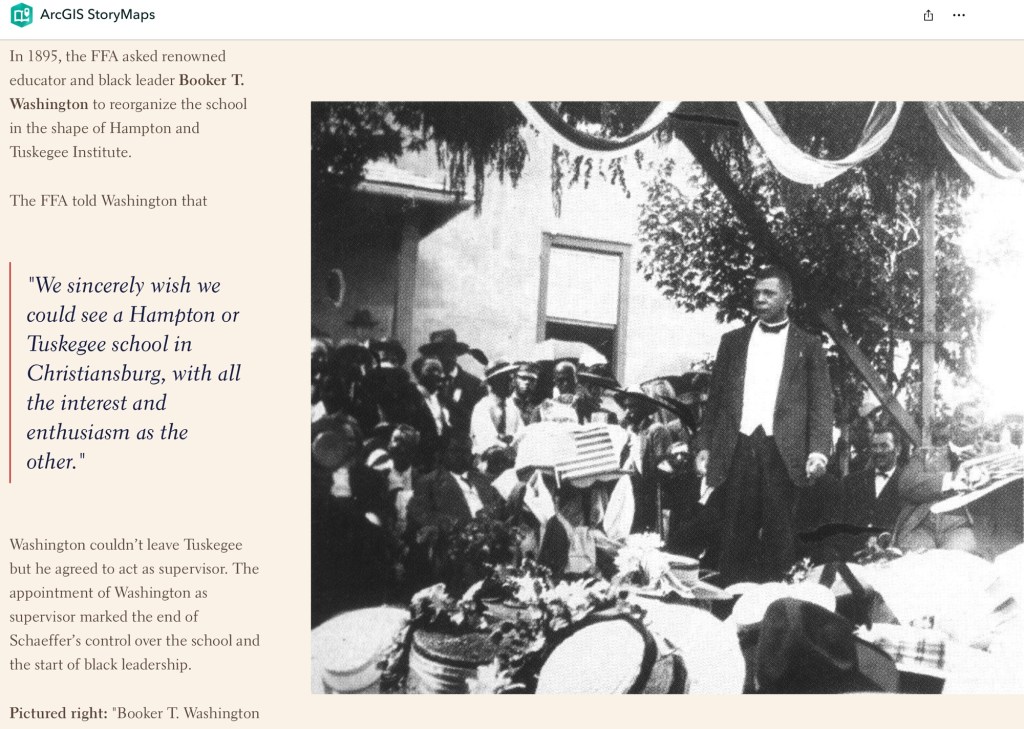
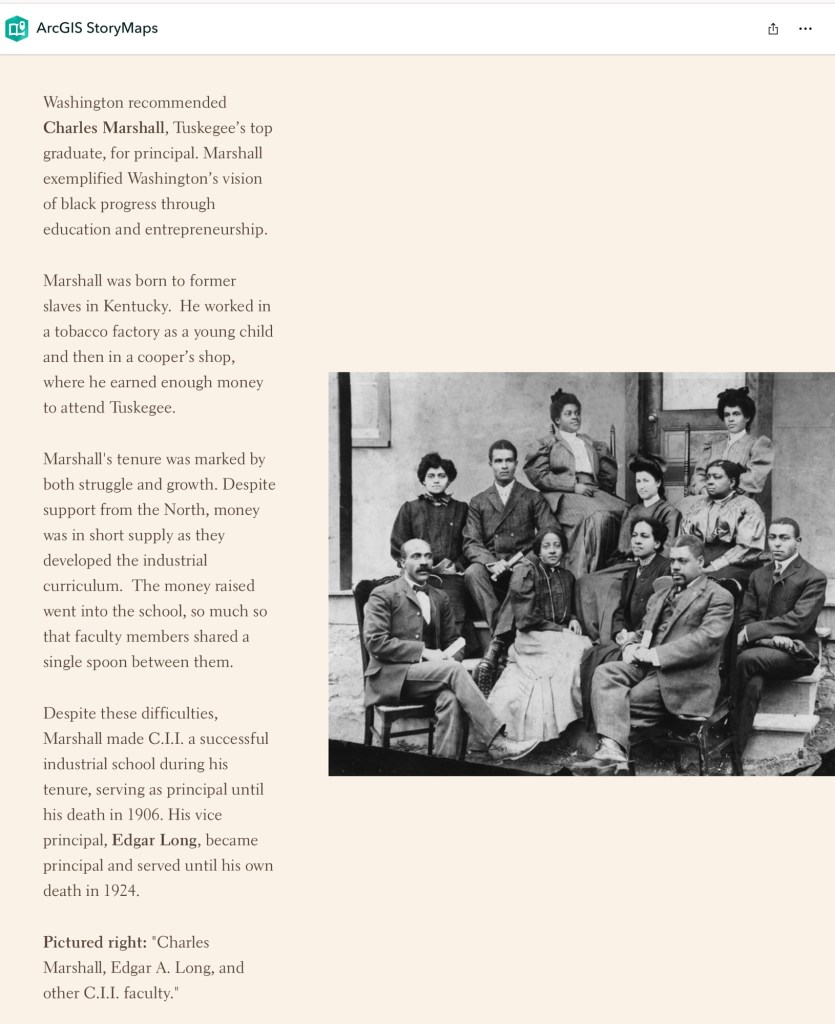
In 1914, Mrs. Walker served on committees of the “Negro Organization Society of Virginia” alongside Edgar A. Long, and in 1932, she served with A.M. Walker on the “Better Home and America” committee. Both Long and A.M. Walker were principals of Christiansburg Institute in nearby Cambria. Furthermore, when the St. Frances Council was established in 1902, Charles Lives Marshal was principal of the school.
These links between Mrs. Walker and influential African American educators in the region suggest the possibility of her involvement with Blacksburg’s community. The search for documentation to confirm her visit continues, but her influence and connections remain an integral part of the story.
The Walton Act of 1894 and the 1902 New Virginia State Constitution – Tools of Voter Suppression
Dan Thorpe’s book, Facing Freedom, provides valuable historical context on how the state legislature curtailed the rights and freedoms of African Americans in Montgomery County. The Walton Act of 1894, presented as a measure to reduce election corruption, required localities to implement a secret written ballot system. This effectively disenfranchised illiterate voters, disproportionately targeting African Americans and many local white men, under the guise of reform.
Further voter suppression was codified in the new Virginia State Constitution, which went into effect in July 1902. It introduced literacy and tax-paying requirements for voting, systematically disenfranchising large segments of the local population.
Notably, this legislative shift coincided with Maggie L. Walker’s creation of the St. Frances Council in Blacksburg. The Council’s membership ledger shows that 60% of its initial members signed up on August 3, 1902, just one month after the new voting restrictions became law. Of these members, 55% were women. This timing highlights the Council’s potential role as a unifying force and a means of empowerment in a community grappling with the loss of political rights.
Uncovering Hidden Histories: The St. Luke Ledger and Its Legacy in the New River Valley
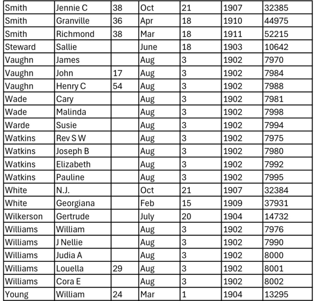
This invaluable ledger is preserved at the Maggie L. Walker National Historic Site in Richmond, Virginia. Unfortunately, it has not been digitized or made available online. The ledger includes the names of families residing in the Blacksburg District, which, at the time, extended east to Ellett Valley, south to Yellow Sulphur Springs, west to the New River, and north to Brush Mountain. As a result, it provides a rare and significant snapshot of individuals—primarily women—who may not appear in other historical records.
This document is more than a membership list; it is a record of people who signed life insurance policies, committing to monthly payments to secure financial stability for their families after their death. The majority of these members were women, demonstrating the critical role they played in building community wealth and hope.
The two pages of this ledger tell a hidden story of the region, preserved in the attic of the Independent Order of St. Luke’s building in Richmond since the organization disbanded in 1984. The ledger also contains information about other Councils established in the New River Valley. These Councils did not operate in isolation; they were interconnected through railroad travel, linking Blacksburg with Councils in Pulaski, Dublin, Christiansburg, Salem, and Roanoke.
The Friends of the St. Luke, Odd Fellows, and Household of Ruth are committed to uncovering and sharing the history revealed by these ledgers. Their efforts will honor the individuals who deeded property, designed, built, and gave meaning to the Hall at 203 Gilbert Street, preserving the stories of our shared regional history for future generations.
Maggie L. Walker Historic Site virtual exhibit and objects. Please ask for permission from the National Park Service if you wish to publish the images.
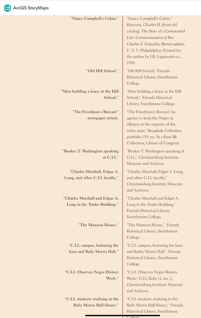
St Frances Council, #235, pages 361-362, Membership Roll 1897-1911 (Courtesy of Maggie L. Walker National Historic Site)St Frances Council, #235, pages 361-362, Membership Roll 1897-1911 (Courtesy of Maggie L. Walker National Historic Site)Transcription of Membership Roll from 1902 to 1911, page 2Transcription of Membership Roll from 1902 to 1911, page 1
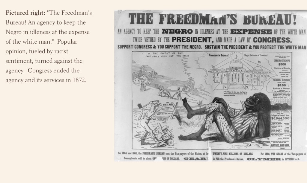
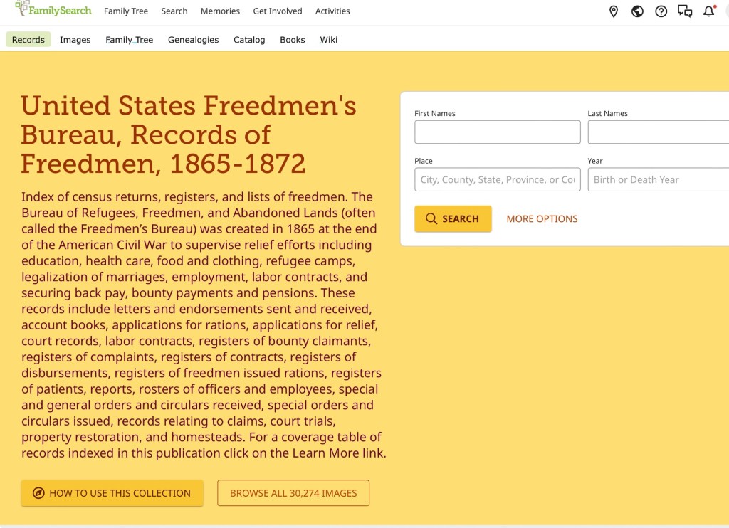
The Index of census returns, registers, and lists of freedmen is overseen by the Bureau of Refugees, Freedmen, and Abandoned Lands, commonly known as the Freedmen’s Bureau. Established in 1865 after the American Civil War, its responsibilities include supervising relief efforts such as education, healthcare, food, clothing, refugee camps, marriage legalization, employment, labor contracts, and ensuring back pay, bounty payments, and pensions.
Family Search records are free but registration is required.
Virginia, Roll 130, Registers of freedmen sent to New England states, 1866-1867
Virginia, Wytheville, Roll 198, Census returns of the black population of Montgomery, Grayson, Smyth, Giles, Roanoke, Craig, and Floyd Counties, 1865 (Images 214-412)
Virginia, Christianburg, Roll 68, Census returns of blacks in Montgomery County
Seven Year Timeline of the Bureau of Refugees, Freedmen, and Abandoned Lands (Freedmen’s Bureau): March 1865 to June 1872.
September 2, 1862: “President Lincoln issued the Preliminary Emancipation Proclamation, declaring that as of January 1, 1863 “all persons held as slaves within any State, or designated part of a State, the people whereof shall then be in rebellion against the United States shall be then, thenceforward, and forever free.”” (Library of Congress)
January 1, 1863: President Lincoln issued the Emancipation Proclamation
April 9, 1865: Lee surrenders to Grant at Appomattox, ending the Civil War.
Juneteenth, 1865 – Smithsonian’s National Museum of African American of History & Culture
National – 3 March 1865: the bureau was created by the War Department of the US Government. Commissioners and Assistant Commissioners as well as General Superintendent of Schools were established.
Virginia – June 1865 to May 1866: Orlando Brown established an office and operated as Commissioner of Virginia, in Richmond.
Virginia – 4 July 1865 to 14 April 1867: Virginia Bureau is organized into 10 districts with an Agent/Superintendent in charge.
Mont. Co – Sept 1865: Buel Carter became the 8th District’s first Superintendent, establishing an office in Christiansburg but move the office to Wythville in September of the same year.
National – Oct 1865 to Jan 1867: Rev. John W. Alvord became Inspector of Finances and Schools to address schools.
Mont. Co – May 1866: Capt Charles S. Schaeffer arrives in Christiansburg as the agent, working under Brevet Maj. George P. Sherwood became Superintendent of the 8th District in June 1866.
Virginia – May 1866 to Aug 1866: Maj. Gen. Alfred H. Terry is Assistant Commissioner, Richmond.
National – 16 July 1866: the Bureau of Freedmen is extended by Congress.
Virginia – Aug 1866 to March 1867: Maj. Gen. John M. Schofield is named Assistant Commissioner .
Virginia – 15 April 1867: The state is reorganization into 10 Sub-districts with Sub-Assistant Commissioner in charge.
Mont. Co- 15 April 1867: District 8 , the central office remained in Wythville. CA Schaeffer remained in Christiansburg.
Virginia – March 1867 to May 1869: Orlando Bowen becomes Assistant Commissioner and Superintendent of Education.
National – 6 July 1968: The Bureau of Freedmen is extended for the last time.
National – 25 July 1868: Congress removes the Bureau’s Assistant Commissioners from the states, but claim agents remain in place.
Mont. Co. – Dec 1868: Freedmen’s Bureau closes its Christiansburg office. Schaeffer retained as Assistant Superintendent of Education.
Virginia – 1 Jan 1869: the 10 Virginia districts are reorganized into 8 Education Sub Districts and Assistant Superintendent of Schools are appointed.
Virginia – 1870: New constitution was ratified which included Public School Funding for all children as a requirement. By 1870 the legislation was set to allow this to happen, though the education would be segregated.
National- Summer 1870: Superintendents of Education removed and headquarters staff reduced.
National – 30 June 1872: The Freedmen’s Bureau was terminated by Congress.
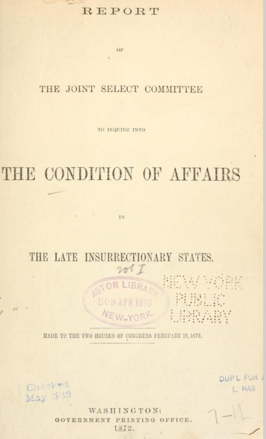
In 1872, a 13-volume compilation of reports and testimonies, including those from previously enslaved individuals, documented a Congressional committee’s investigation into the Ku Klux Klan and other insurrectionary movements in the former Confederate states.
In 1872, a 13-volume compilation of reports and testimonies, including those from previously enslaved individuals, documented a Congressional committee’s investigation into the Ku Klux Klan and other insurrectionary movements in the former Confederate states.
While Virginia is absent from this congressional report, the testimonies offer valuable insights into the beliefs, attitudes, misconceptions, and misdirections surrounding the mistreatment of newly freed people residing in the former Confederate states.
Captain Charles S. Schaeffer arrived in Christiansburg soon after the emancipation of enslaved people of Southwestern Virginia. In April 1866 he was appointed as an agent of the Bureau of Refugees, Freedmen, and Abandoned Lands (referred to as the Freedman’s Bureau). Schaeffer was US soldier who asked for to be assigned as an agent in Southwestern Virginia. He was assigned to Giles and Montgomery Counties, with headquarters in Christiansburg, VA.
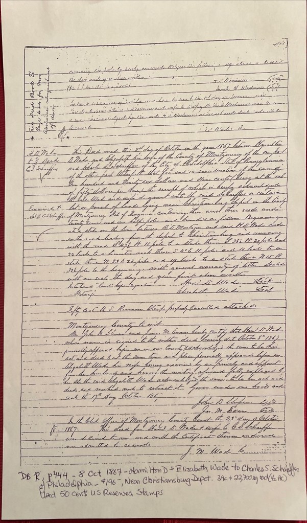
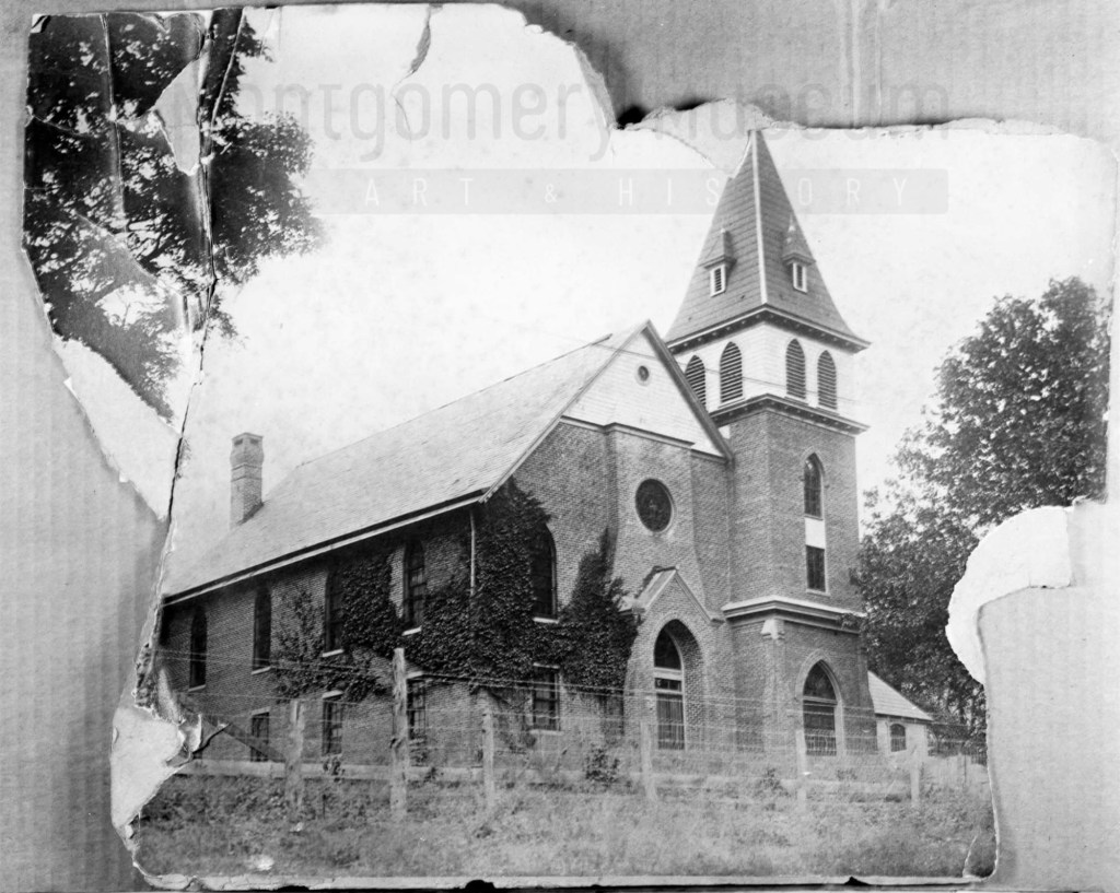
October 8, 1867, Hamilton D. and Elizabeth Wade sold Schaefer about 3.5 acres for $196 on a road leading from the Depot (Cambria*) to the town of Christiansburg (deed book R, pg 444). It is upon this land that Schaefer built a home of stone on the western portion and called it Zion Hill.
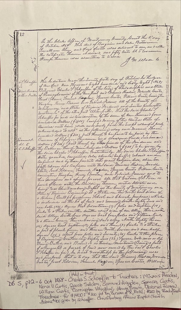
About one year later, October 6, 1868, Schaeffer deeded about a half an acre to the Trustees to be used as a school and the Christiansburg African Baptist Church (deed book S, pg 12). The Trustees: Minnis Headen, Norvell Curtis, Jacob Seldon, Samuel Hayden, Spencer Curtis, William Curtis, Carrington Vaughn, Henry Brown, and Gabriel Farrow. The cost of the land was $1,400. The Freedmen’s Bureau paid $300, the Friends’ of the Freedmen paid $200, & Schaeffer gifted the balance of $900. As noted in the deed a house was on the land, in use as a school and meeting house by the time of this deed. We believe this is the first school at this location. Schaeffer and the Trustees built two other structures with time.
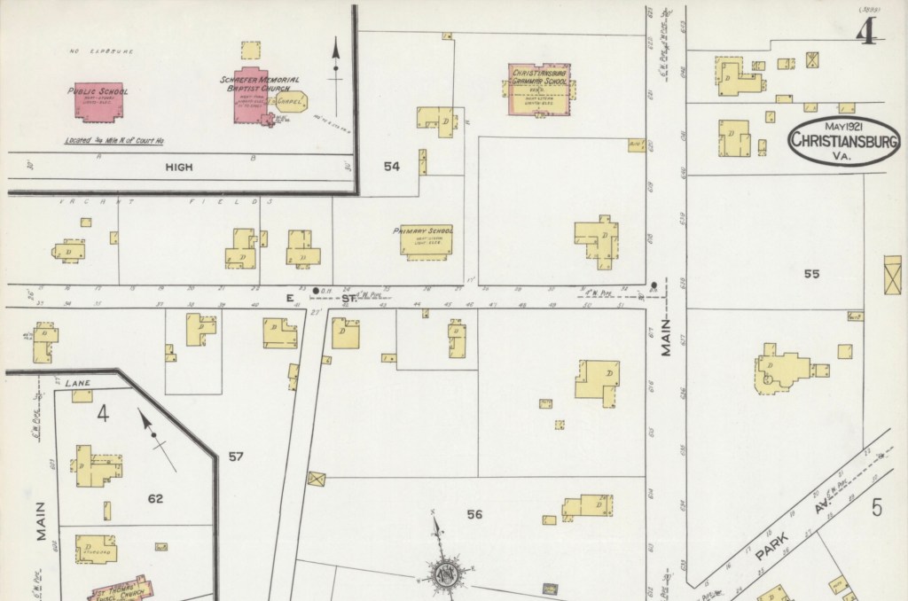
Deed Book R, pg 444. Hamilton D. & Elizabeth Wade to Charles S. SchaefferDeed Book S, pg 12. Schaeffer, Bureau Freedmen & Friends’ of Freedmen to Trustees of the Christiansburg African Baptist ChurchZion Hill – 1921 Sanborn Fire Map of Christiansburg with the School and Baptist Church in red (brick) at the top, left.
*The Depot was Bangs which then was named Cambria in the late 1890s.
Photograph courtesy of the D.D. Lester Collection, Montgomery Museum of Art & History
Linda Killen transcribed the reports of Brevet-Captain Charles S. Schaeffer who held the post of agent for the Bureau of Refugee, Freedmen and Abandoned Lands during the early years of Reconstruction. More information about Schaeffer can be found at Christiansburg Institute, Inc.. Schaeffer sent this list of African American Freedmen to his reporting officer, Bvt. Brig. Genl. O. Brown, dated 15 March 1867 (page 18). Minnis Headen (Hadean) was listed on the deeds as Trustee for the Hill School and Christiansburg African Baptist Church.
“C. Minnis Hadean – Age 40 – Blacksmith – Christiansburg Va. – can read, write and cipher – one of the best colored men in the state.”
John Campbell – Age 40 – Farmer – Big Springs Depot Mont’y Co. Va – can read and write – owns property – was free before the war.
Peter Noulen (?) – Assistant to a Machinist – Depot of the Va. & Tenn. R.R. – Central Depot, [Radford], Mont’y Co. Va. – can read a little.
Sampson Gleaves – Age 35 – Farmhand – Christiansburg P.O. Lives one mile from town – Can read (and write a little).
Robert D. Jones – Age 30 – Farmer – Christiansburg P.O. Lives six miles from town – Can read and write.
Felix Johnson – Age 30 – Brick Layer – Christiansburg P.O. Lives in the direction of Blacksburg Va. – Can read and write.
John P. Taylor – Age 35 – Farmhand – Christiansburg P.O. Lives in the direction of the White Sulphur Springs – Can read & write.
Richard Taylor – Age 65 – Farmer & Preacher – Christiansburg P.O. – Lives near Blacksburg Mont’y Co. Va. – Cannot read nor write, but is quite intelligent.