Christiansburg Industrial Institute, Hill School and the Schaeffer Memorial Baptist Church – 1913 Sanborn Fire Map

This 1913 Sanborn Fire Map of Christiansburg, Virginia offers a rare glimpse into the heart of the town’s early African American community during segregation. The map identifies key institutions including the Hill School Elementary, the Christiansburg Industrial Institute, and Schaeffer Memorial Baptist Church — places that anchored education, faith, and community life for Black residents in Montgomery County.

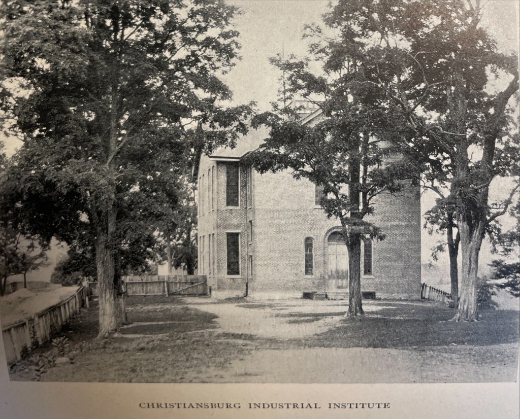
The Sanborn Fire Insurance maps are often the only early glimpse of buildings in rural towns over time. Christiansburg Industrial Institute moved from the Zion Hill location to the Lattimer Plantation site, north west of Christiansburg, at the turn of the 20th Century. This Sanborn Fire Insurance Map from Christiansburg, Montgomery County, Virginia was published by the Sanborn Map Company, dated Sep, 1913. The key to the maps is at the end.

1913 Christiansburg Industrial Institute

1913 Sanborn Fire Insurance Map (Courtesy of the Library of Congress)

The map is of Christiansburg Industrial Institute, situated north west of Cambria and north of Christiansburg courthouse. Note that frame constructed buildings are coded yellow and red for the solid brick building. The Baily Morris Building which housed the girls dorm, assembly hall, dinning hall and kitchen (close-up below) is heated by steam and lighted by electricity.

“Baily-Morris” Building

The Morris Hall Boys’ Dorm is both red and yellow, denoting built of a combination of building materials. The building is heated by hot water and lighted by electricity. Note that the buildings were supplied with water by 2,500 ft of pipes connected to the 10K gal water tank on the hill. The tank is filled by a Worthington Pump, moving water from a spring.

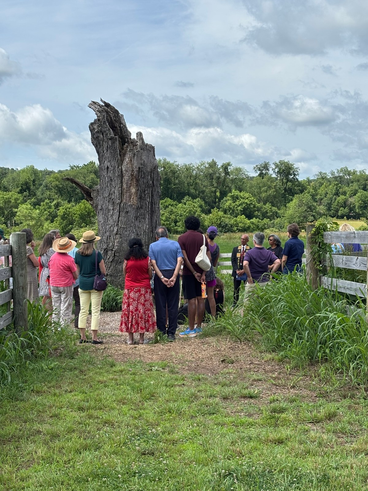
The girls and boys dorms were named for two Friends’ of the Freedmen of PA, Elliston P. Morris and Joshua L. Baily. They also donated money to construct the water system which was installed in 1907, before either Christiansburg or Blacksburg had a community water system. (A Vision of Education, Selected Writings of Edgar A. Long, Anna Fariello, Ed. Christiansburg Institute, Inc. 2021, pg 86,)

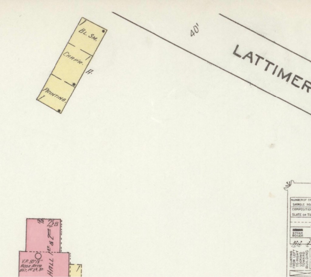
The Lattimer Mansion House, wood framed, was heated by stove and not connected to the water supply. The house was used as classrooms. Note the printing, carpenter and black smith shop close to the entrance road.

1913 Hill School & Schaeffer Memorial Baptist Church

1913 Sanborn Fire Insurance Map (Courtesy of the Library of Congress)

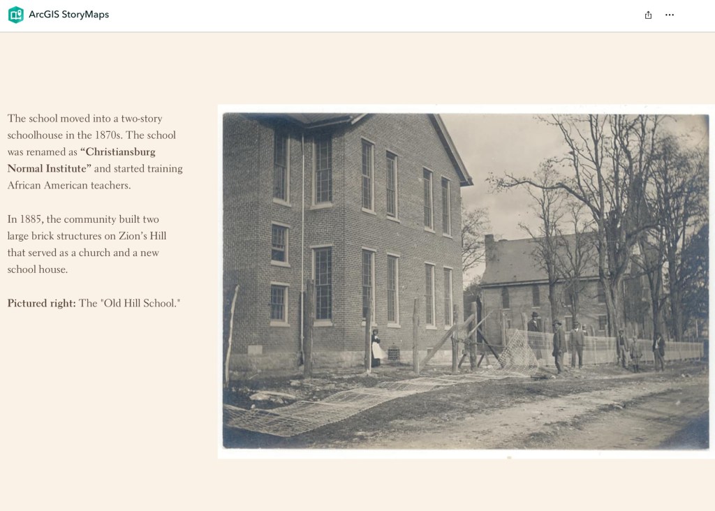
This map is of Zion Hill which is located on the ridge (now High Street) between Cambria and Christiansburg. The brick (red) “Public School” housed the Christiansburg Industrial Institute before that secondary school moved to the Lattimer Plantation property by the turn of 20th century. This brick school, built by 1885, was converted to a primary school for African American children after CII moved. As noted by the Sanborn map, the building was heated by stoves and lighted by electricity.

Image of the Hill School from The Story of a Consecrated Life, Commemorative of Rev. Charles S. Schaeffer by CH Harrison, 1900. High Street is visible.

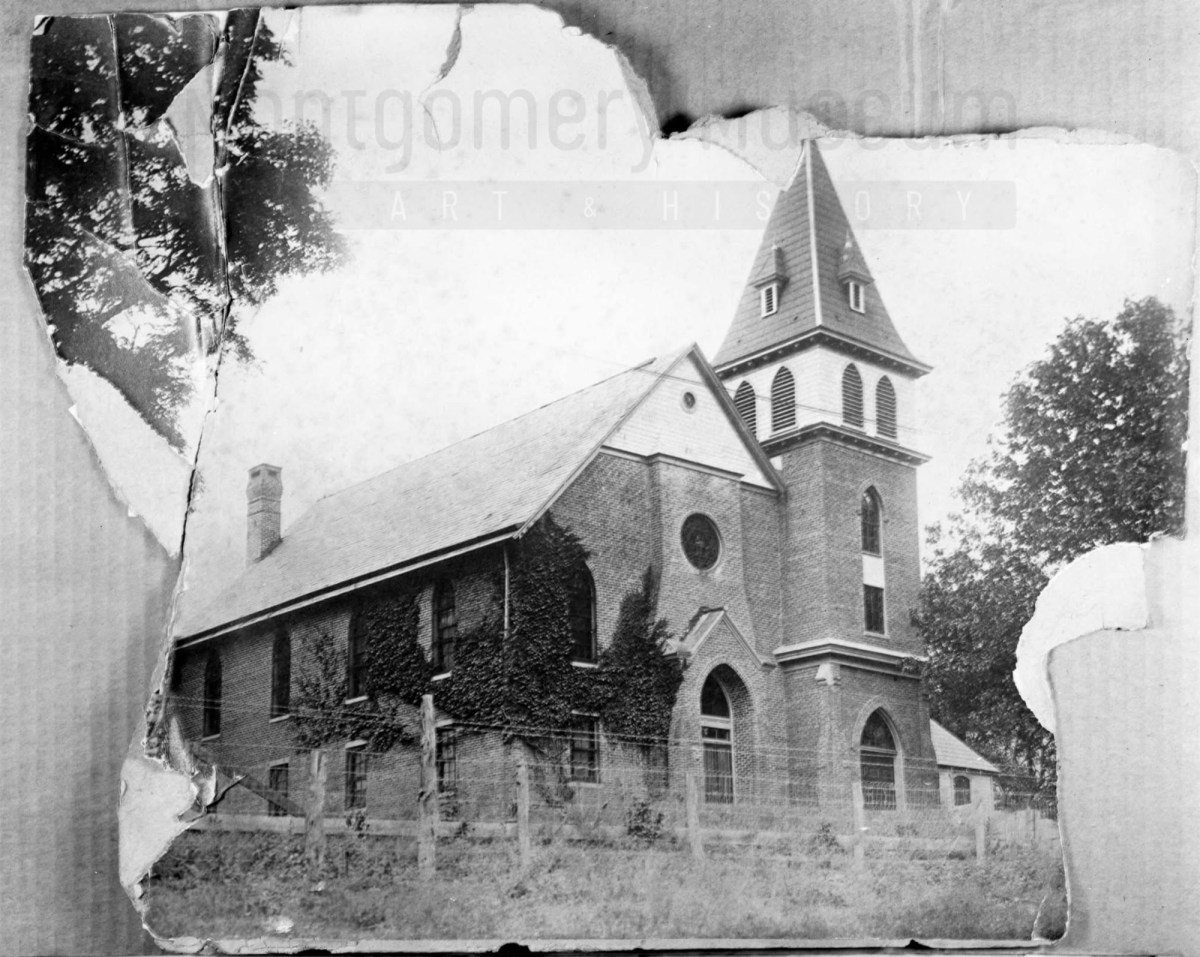
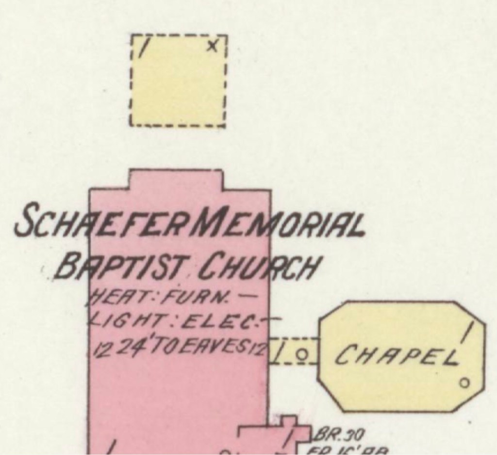
The Schaeffer Memorial Baptist Church is also of brick and built by 1885. Charles S Schaeffer’s memorial brass plaque were unveiled 1 October 1899, after he died in May of that same year. Note the frame chapel to the left (east) of the brick structure.

Image of Schaeffer Memorial Baptist Church from The Story of a Consecrated Life, Commemorative of Rev. Charles S. Schaeffer by CH Harrison, 1900. High Street is visible in the foreground.
Later photograph, courtesy of the D.D. Lester Collection, Montgomery Museum of Art & History

On the Sanborn map, note the small frame, 1 story building behind the church? This may be the first school/church building on Zion Hill. The deed (DB S, pg 12, Oct 1868) and Harrison, 1900 * note the existence of this building. The brick school on the 1913 Sanborn map was the third version of this school at this site. The second school on Zion Hill was a 2 story & frame building, used between 1974 and 1885. (The rented Campbell house was the first school but it was not located on Zion Hill.)*

The image of the small school/meeting house shows a one story frame building with hip-roof and double stove-pipes. The dressed limestone block foundation was typical in this area and seen on buildings dating from early 1800s to the turn of the 20th century.

Image of the first school house on Zion Hill from The Story of a Consecrated Life, Commemorative of Rev. Charles S. Schaeffer by CH Harrison, 1900. High Street is visible in the foreground.

* The images and much of the information about Zion Hill comes from The Story of a Consecrated Life, Commemorative of Rev. Charles S. Schaeffer by CH Harrison, 1900.

The last interesting note about the Sanborn map is that the church was 160 feet to the Fire Department. The map did not indicate a source of water.

North Fork River Rural Historic District

The North Fork Valley Rural Historic District spans nine miles and 10,200 acres in Montgomery County, Virginia. Along scenic Route 785, this ArcGIS tour explores geology, farming, social and architectural history—plus schools and churches—across a multi-generational rural landscape.

Image courtesy of the North Fork Valley Rural Historic District website, accessed May 4, 2026.

The North Fork Valley Rural Historic District spans nine miles and 10,200 acres in Montgomery County, Virginia. Along scenic Route 785, this ArcGIS tour explores geology, farming, social and architectural history—plus schools and churches—across a multi-generational rural landscape.

Search the terms “African American” or “enslaved” to uncover information connected to the enslavement of men, women, and children.

Unlocking the Past: Virginia Untold & Local Records

Virginia Untold offers a rich online archive of African American history. Search Montgomery and Wythe County records, and use downloadable PDFs for more precise, in-document searching.

Virginia Untold: The African American Narrative

Library of Virginia’s Virginia Untold: The African American Narrative provides a comprehensive online archive of African American and related history. These primary sources are invaluable for researchers and genealogists. Search “Montgomery County, VA” to locate local materials, and include “Wythe County, VA,” as some Montgomery County records are held there.

While the site offers search functionality, downloading the PDF transcriptions allows for more targeted searching. For example, a name search will return relevant documents, but locating specific references within them requires opening the PDF and using your browser’s search function. Please note that name spellings may vary.

Don’t forget to scroll down the Virginia Untold Search page for additional online resources. Also, the Library holds a huge collection of other online resources that is growing.

Hidden Histories: Virginia Letters & Clippings Mentioning an Enslaved Person

This collection of archival letters and newspaper clippings—many discovered through eBay searches focused on Virginia—is shared in the spirit of public history and community research. By making these materials accessible, we hope they may help individuals uncover, reconnect with, or deepen their understanding of their ancestors and the stories that shape our shared past.

This is a collection of archival letters and newspaper clippings, many of which were discovered through eBay searches focused on Virginia. We’re sharing them in the hope that they may help someone uncover or connect with their ancestors.

Disclaimer: Any text in quotation marks reproduces the seller’s original listing. As with all archival materials, we encourage careful interpretation, as this information has not been independently confirmed.

February 27, 1798 – Mention of Dolly

“This rare and historical slave letter from 1798 is Eliza Whiting to James McCormack is a must-have for collectors or slavery historian. The letter, written on old paper and hand-stamped for cancellation, depicts the harsh realities of slavery and commerce in the United States. Specifically relating to the Frederick County Virginia area in 1798.

The letter reads…

Mr. George Taylor 

Frederick County 

-for favor

I hereby inclose a bond of James McCormack for a Negrow called Dolly of mine. He has carried her last go-over in to Berkley Pshs (Plantation) is(has) not yet returned – I shall mark you to call on him for this money – see that she has had the clothing stipulated for mention – Of hire her on I with the assist of my negroes.

Your Most Obliged Servant – Feb 27th 1798 – Eliza Whiting”

Elizabeth Burwell Whiting was the daughter of Lewis Burwell (1710–1752) of Carter’s Creek, Gloucester County, Virginia. A graduate of Cambridge who studied at the Inner Temple, Burwell served in the Virginia House of Burgesses and was acting governor of the colony in 1750. Mrs. Whiting’s husband, Beverley Whiting, was probably the son of Peter Beverley Whiting (c.1707–1755) of Gloucester County. Peter Beverley Whiting may have been the son of the Beverley Whiting who was one of George Washington’s godfathers.

James McCormick was born on June 8, 1768, in Frederick, Virginia, United States. His father was also named James McCormick, and his mother was Mercy Lupton. In 1784, James married Elizabeth Hanna in Rockbridge, Virginia. They had at least three sons. James passed away in 1841 in his hometown at the age of 73.

The letter’s aspects include a Stampless Courier denomination, a year of issue 1798, and a place of origin in the United States. It is a valuable addition to any collection and a testament to the rich history of Maryland. Don’t miss out on the opportunity to own a piece of history.

The piece has significant staining, probably dating to the time of creation, as it could be ink, or mud, or caused from water during delivery to its recipient. 

Upon further research the name appears to be Eliza “Burwell” Whiting who was from a prominent family out of Prince William County.”

April 22, 1840 – Mention of Bill

“April 22d 1840 [-] My Dear Sir [-] I send Bill down with a load of wheat which I wish you would be good enough to send me the money for as I want some to pay some little debts – Please send me as much plaister as Bill can bring up. – Camden is looking fine mooving [sic] like a bird. I gave him on Sunday week last a mile run with my [filley?] track very deep from recent harrowing [-] he ran his mile without much persuasion in 1 m[inute] 55 [seconds] his shoes on.  I should like to know how Porter’s nag is coming on. My filler is so very delicate that I fear she will weaken. I do not think that she will tire or give back in. You may possibly have heard the result of Porter’s trial a few days ago. he went down to see it. I should be much pleased to see you at our race which comes off on the 8th of May. I had at one time consented at the request of Porter that Col. J.C. Gibson should run his colt in our race but on hearing that his colt is in the same stable with Porter’s I could not consent to any such arrangement. Please write me by Bill [illegible] Bonetis arrived safe and is lodged safe in her stall at the track. I gave Camden a half mile yesterday with one that is considered fast about Richmond and it was a very nice thing a very close business. Most respectably friend. A. M. Payne.”


“The author of this letter, Arthur A.M. Payne (1804-1868), was a member of the longstanding family associated with Fauquier County, and the last familial owner of the Clifton estate in that county, which he sold in 1854 on moving to Missouri, where he passed away in 1868. His father was Captain William Payne (1755-1833) who served in the Virginia Militia under General Richard Henry Lee during the American Revolution. A.M. Payne was in turn the father of Confederate States Army Brigadier General William Henry Fitzhugh Payne (1830-1904).
The man mentioned in the letter, Colonel Jonathan Catlett Gibson (1793-1849), was a notable landholder in both Culpeper and Rappahannock County, Virginia.  

Colonel Gibson served in the Virginia militia during the War of 1812 and rose to command rank in later years.  He was elected to the Virginia House of Delegates in 1830. Originally married to a niece of George Washington, he remarried after her death, raising five sons, all of whom served in the Confederate Army. “

November 22, 1845 – Mention of Abb, Nancy, Mary, Martha, Rachel, Luce, Big Davy

“Remarkable Stampless folded letter written November 22, 1845 by John Jerdone, a prominent plantation owner in Spottsylvania, Virginia and sent to a relative, William Jerdone in Mount Sterling, New Kent Court House, VA.   

Content is about the sale 25 enslaved negro women and children, the prices obtained. Rest of content is farming news, selling hogs in Richmond etc.”

As noted by Dan Thorp in Seeking Justice: The Extraordinary Freedom Suits of an Enslaved Virginia Family, fluctuations in the enslaved labor market in eastern Virginia reflected broader economic shifts in the decades before the Civil War. Periods of declining prices—such as those described in this letter, where individuals were said to be “overstocked”—often prompted enslavers to sell people out of the region, feeding the domestic slave trade to the Deep South. This language of “overstock” underscores the brutal commodification of human lives, where people were treated as surplus property in a market economy, and their forced movement reshaped families and communities across the South.

1851 March – Mention of Isetta

An autograph letter signed S.W. Leigh to Benjamin Rush Floyd, discussing personal matters and asking for advice on the sale of a slave woman named Isetta.

 Excerpt:

“[….] Isetta is hired this year to a man who owns her husband and who I am told would like to purchase her and from the present-price of cotton – I suppose he would give six hundred for her….

 2 pp. , 25 x 18,5 cm, leaf address “Mr. B.R. Floyd, Wythe, Virginia” sent from La Grange, Kentucky, March 1851.

Note: The recipient of the letter, Benjamin Rush Floyd (1811-1860), American lawyer and politician was a member of the Virginia House of Delegates from 1847-1848, and state senator from 1857-1858.”

Montgomery County’s Changing Borders & the African American Story

The Formation of Montgomery County, Virginia and Why it Matters to Regional African American History

When Virginia’s earliest European colonial settlers first pushed westward beyond the Blue Ridge Mountains, they entered the border lands already inhabited by Indigenous peoples for thousands of years. As Europeans laid claim to these territories in the 18th century, Virginia’s county boundaries began shifting rapidly to keep pace and the need for local governance.

At first, all of western Virginia was considered part of vast counties based far to the east. Augusta County, created in 1738, stretched from the Blue Ridge to the Mississippi River—a landmass so large it was nearly impossible to govern effectively. As settlement expanded, Augusta was gradually carved into smaller counties.

Botetourt County was created in 1770 out of Augusta, and just two years later, in 1772, Fincastle County was formed to cover the far southwest. But Fincastle itself was short-lived: in 1776, it was split into three new counties—Montgomery, Washington, and Kentucky (the latter eventually becoming the Commonwealth of Kentucky).

Thus, Montgomery County was officially established in 1776, named in honor of General Richard Montgomery, a Revolutionary War hero.

Like most early counties, Montgomery did not remain the same size for long. As population grew and communities demanded closer courts and local representation, Montgomery’s original boundaries were gradually reduced.

1790: Wythe County was formed from Montgomery. 1790: Parts of Montgomery contributed to the creation of Kanawha County (now in West Virginia). 1806: Giles County was carved from Montgomery, Monroe, Wythe, and Tazewell. 1806–1830s: Additional shifts continued, with Montgomery giving land to Floyd (1831), Pulaski (1839), and others.

By the mid-19th century, Montgomery County had taken on the approximate shape we recognize today.

Why this matters

Tracing these changing boundaries shows how the western border lands of Virginia evolved from a vast Indigenous landscape into the network of counties we know today. When we study Montgomery County’s formation and its changing borders, we are not only tracking political geography—we’re also uncovering how those shifts shaped the daily realities of enslaved people and freedmen. The “line on a map” often meant the difference between where families were recorded, where they could live, and how they could begin to claim freedom and opportunity.

County seats like Christiansburg were not only centers of trade and government but also the location of the slave market and the courthouse records that tracked the lives of enslaved people. After emancipation, those same courts became the places where freedmen registered marriages, secured contracts, and sought land. As county lines shifted, so too did the jurisdictions that controlled access to justice, opportunity, and community life.

The flip book of maps below is a helpful resource to understand how the boundaries changed with time. Virginia Atlas of Historical County Boundaries. Begin on page 395.

Virginia Atlas of Historical County Boundaries

Further Discussion on How Shifting Boundaries Change Lives

Laws & Records

When county boundaries changed, so did the courthouse where records were kept. For enslaved people, this meant that bills of sale, wills, deeds, and manumission papers might end up filed under different counties as the boundaries shifted. After emancipation, the same was true for marriage licenses, labor contracts, and land purchases by freedmen. This scattering of records makes it both complicated when tracing family histories.

Shaping Community, Labor & Education

County lines determined where enslaved people were forced to labor, where patrols were organized, and where courts enforced slavery laws. After emancipation, those same boundaries shaped freedmen’s access to work, land, and schools. For example, as new counties like Giles or Pulaski were created from Montgomery, Freeman might find themselves suddenly in a different jurisdiction, dealing with a new local power structure.

Education also reflected these divisions. Freedmen near Christiansburg had better access to schools supported by the Freedmen’s Bureau, while those in rural reaches of the county received little help.

Courts and Law

During slavery, county seats (like Christiansburg) were centers of trade, law, and the slave market. Enslaved people were taken to county courts for sales, trials, and punishment. After emancipation, those same county seats became the centers where freedmen registered marriages, secured legal recognition, and later sought protection under Reconstruction policies.

Land, Freedom, and Mobility

For freedmen, land ownership was key to independence. But access to land varied widely from one county to another, depending on who owned large estates, which lands were subdivided, and how local officials treated Black landholders. County boundaries thus shaped the possibilities of building self-sustaining communities after emancipation.

More Maps

Montgomery County Resources

Montgomery County, Virginia Resources and the Formation of the County Over Time

National Register of Historic Places Application – 1989

National Register of Historic Places Application – 1989

This searchable document is a rich source of information about the county and its wider connections. For example, it notes that the New River boatmen once lived on Kent Farm, where they were enslaved by James Randle and Margaret Cloyd Kent prior to emancipation (see page 13). Additional details about Kentland and these freedmen can be found in the following postings: Historic Kentland and Historic Wake Forest

The names of some of the black boatmen of 19th-century Montgomery County include Frank Bannister (who was a boatman on the James River before the Civil War), Calvin Bannister, Roland Stuart, George Brown, and Lewis Smith.


Montgomery County Reconnaissance Level Survey, 1986

This report that was written by Gibson Worsham, Dan Pezzoni, Charlotte Worsham, David Roenizer, and others. It addresses the following: 1) Overview of the county’s history, 2) A comprehensive inventory of significant structures and sites in the county and 3) Maps delineating the location of said structures and sites. Similar to the report above, this is a wealth of information about the county.


More information can be found on this website: Gatherings Blacksburg History


The Formation of Montgomery County, Virginia and Why it Matters to African American History of the Region

When Virginia’s earliest European colonial settlers first pushed westward beyond the Blue Ridge Mountains, they entered the border lands already inhabited by Native peoples for thousands of years. As Europeans laid claim to these territories in the 18th century, Virginia’s county boundaries began shifting rapidly to keep pace and the need for local governance.

At first, all of western Virginia was considered part of vast counties based far to the east. Augusta County, created in 1738, stretched from the Blue Ridge to the Mississippi River—a landmass so large it was nearly impossible to govern effectively. As settlement expanded, Augusta was gradually carved into smaller counties.

Botetourt County was created in 1770 out of Augusta, and just two years later, in 1772, Fincastle County was formed to cover the far southwest. But Fincastle itself was short-lived: in 1776, it was split into three new counties—Montgomery, Washington, and Kentucky (the latter eventually becoming the Commonwealth of Kentucky).

Thus, Montgomery County was officially established in 1776, named in honor of General Richard Montgomery, a Revolutionary War hero.

Like most early counties, Montgomery did not remain the same size for long. As population grew and communities demanded closer courts and local representation, Montgomery’s original boundaries were gradually reduced.

  • 1790: Wythe County was formed from Montgomery.
  • 1790: Parts of Montgomery contributed to the creation of Kanawha County (now in West Virginia).
  • 1806: Giles County was carved from Montgomery, Monroe, Wythe, and Tazewell.
  • 1831: Montgomery giving land to Floyd
  • 1839: Montgomery giving land to Pulaski
  • 1892: City of Radford

By the mid-19th century, Montgomery County had taken on the approximate shape we recognize today.

Why This Matters

Tracing these changing boundaries shows how the western border lands of Virginia evolved from a vast Indigenous landscape into the network of counties we know today. When we study Montgomery County’s formation and its changing borders, we are not only tracking political geography—we’re also uncovering how those shifts shaped the daily realities of enslaved people and freedmen. The “line on a map” often meant the difference between where families were recorded, where they could live, and how they could begin to claim freedom and opportunity.

County seats like Christiansburg were not only centers of trade and government but also of the slave market and the courthouse records that tracked the lives of enslaved people. After emancipation, those same courts became the places where freedmen registered marriages, secured contracts, and sought land. As county lines shifted, so too did the jurisdictions that controlled access to justice, opportunity, and community life.

The flip book of maps below is a helpful resource to understand how the boundaries changed with time. Begin on page 395.

Virginia Atlas of Historical County Boundaries

Frederick Douglass and the Meaning of Independence

On July 5, 1852, Frederick Douglass delivered his powerful speech, “What to the Slave Is the Fourth of July?” to the Rochester Ladies’ Anti-Slavery Society at Corinthian Hall in Rochester, New York. In it, he confronted the meaning of Independence Day from the perspective of those still enslaved, asking what freedom could mean in a nation that denied it to millions.

On July 5, 1852, Frederick Douglass delivered his powerful speech, “What to the Slave Is the Fourth of July?” to the Rochester Ladies’ Anti-Slavery Society at Corinthian Hall in Rochester, New York. In it, he confronted the meaning of Independence Day from the perspective of those still enslaved, asking what freedom could mean in a nation that denied it to millions.

The copies of both the full version and excerpts are available.

Excerpt Versions

Full Versions

Audio Versions

Context and Biographical Information

Back Story Radio – excellent production and provides insightful context to the time and place.

The Compromise of 1850 included the Fugitive Slave Act, a federal law signed just two years before Mr. Douglass’s 1852 speech. As historian Eric Foner has noted, this act demonstrates that pro-slavery states were willing to abandon their usual defense of states’ rights when it came to protecting the institution of chattel slavery. Eric Foner on the Fugitive Slave Act.

The U.S. Statutes at Large, Volume 9 (1845-1847), 29th through 31st Congress.

EdSiteMent , National Endowment for the Humanities, provides information, context and lesson plans.

Library of Congress, papers and documents of Frederick Douglass

Original Biographies that are available online

Timeline of Mr Douglass’ life, presented by the Library of Congress. Brief Summary Based on the Library of Congress

Frederick Douglass married Anna Murray in 1838. Together, they had five children: Rosetta (1839), Lewis Henry (1840), Frederick Jr. (dates vary, likely born around 1842–1843), Charles Remond (1844), and Annie (1849). The family moved to Rochester, New York in 1847, where Douglass continued his abolitionist work.

In 1859, following the failed John Brown raid, Douglass fled briefly to Canada to avoid arrest, returning in 1860—the same year his daughter Annie died. That year, Abraham Lincoln was elected president, and South Carolina became the first state to secede from the Union.

During the Civil War, slavery was abolished in Washington, D.C. in 1862, and the Emancipation Proclamation took effect in 1863, freeing enslaved people in Confederate states. That year, Douglass met with President Lincoln to advocate for Black soldiers and equal treatment.

On April 9, 1865, General Lee surrendered to Grant, effectively ending the Civil War. Lincoln was assassinated five days later. The 13th Amendment, abolishing slavery, was ratified later that year.

Douglass remained active during Reconstruction, fighting for civil rights and women’s suffrage. In 1870, the 15th Amendment guaranteed the right to vote regardless of race. That same year, after a suspicious fire at their Rochester home, the Douglass family moved to Washington, D.C., where Douglass was nominated for vice president by the Equal Rights Party, alongside presidential candidate Victoria Woodhull.

In 1874, Douglass became president of the Freedmen’s Savings Bank in a final effort to save the institution, which was failing and held the savings of many newly freed people. In 1875, Congress passed a Civil Rights Act to combat public discrimination, but in 1883 the U.S. Supreme Court rules the act was unconstitutional.

By 1877, Douglass had been appointed U.S. Marshal for the District of Columbia and later purchased a home in Anacostia (now Cedar Hill). Anna Murray Douglass, his wife of 43 years, died in 1881. He married Helen Pitts in 1884.

From 1889 to 1891, Douglass served as U.S. minister to Haiti and chargé d’affaires to Santo Domingo. He died unexpectedly in 1895.

Quotes From “What To A Slave Is the Fourth of July?”

Now, take the Constitution according to its plain reading, and I defy the presentation of a single proslavery clause in it.  On the other hand it will be found to contain principles and purposes, entirely hostile to the existence of slavery. . . . 

Great streams are not easily turned from channels, worn deep in the course of ages. They may sometimes rise in quiet and stately majesty, and inundate the land, refreshing and fertilizing the earth with their mysterious properties. They may also rise in wrath and fury, and bear away, on their angry waves, the accumulated wealth of years of toil and hardship. They, however, gradually flow back to the same old channel, and flow on as serenely as ever. But, while the river may not be turned aside, it may dry up, and leave nothing behind but the withered branch, and the unsightly rock, to howl in the abyss—sweeping wind, the sad tale of departed glory. As with rivers so with nations.

The Merry Tree

The Merry Tree, now a broken and weathered stump southeast of the Preston home, once stood as a silent witness to over a century of enslavement. It remains a sacred place where descendants return to honor their ancestors. We are gathering stories, photos, and memories connected to this tree. Let’s preserve its powerful legacy.

Help Us Tell the Story of the Merry Tree

For over a century, the Merry Tree stood as a silent witness to the lives of the 226 people enslaved by the Preston family at Smithfield, Blacksburg, Virginia. Planted near the time the Prestons built their home, this tree bore witness to generations of forced labor, family separation, resistance, and endurance. Though now reduced to a broken and weathered stump, the Merry Tree remains a place of deep meaning—especially for the descendants of those once enslaved, who return here to remember, honor, and reflect.

We are seeking to gather as much information, memory, and meaning as possible about this special tree. Did your family speak of it? Do you have photos, stories, or oral history connected to the Merry Tree? Whether you are a descendant, community member, or researcher, your voice matters in helping us preserve and understand the role this sacred place played in Black history in Montgomery County.

Please share what you know. Together, we can ensure the story of the Merry Tree—and those who stood beneath it—is never forgotten.

#MerryTree #BlackHistory #SmithfieldVoices #CommunityMemory #TruthTelling

https://themerrytree.vt.domains

https://news.vt.edu/articles/2022/03/unirel-merryoak.html

https://youtu.be/MRtNTU6f5Ao?si=M82B2-3mk2GNea19

https://fb.watch/Al2YW58dry/?fs=e

https://fb.watch/Al2_CTJG-s/?fs=e

https://news.vt.edu/videos/k/2024/08/1_tznvjyyu.html

https://www.wfxrtv.com/news/local-news/new-river-valley-local-news/merry-oak-tree-brings-dozens-together-to-remember-enslaved-families/

https://historicsmithfield.wordpress.com/2017/02/28/merry-oak/?fbclid=IwQ0xDSwLCMlZleHRuA2FlbQIxMQABHv0vjeN0Bf21sot8c_kdCGs34nl7HL1kqw3D79M5olBaYuk-obb_VAJ2ggBQ_aem_hTV02h4a8q1x_cCGxX_nBA

https://montcova.com/2024/08/02/historic-smithfield-dedicates-merry-oak-bench/

https://www.wvtf.org/news/2025-06-19/juneteenth-event-honors-226-people-who-were-enslaved-at-smithfield-plantation

https://virginiahumanities.org/events/2022/03/1872-forward-vt/

https://virginiahumanities.org/2022/08/more-than-a-fraction-the-power-of-the-merry-tree/

https://morethanafraction.com/uploads/1/3/2/3/132308734/drkmoseleyhobbs_cp.pdf

Witness Tree – Sycamore Guarding the Spring

This enormous sycamore stands just east of the spring that once provided potable water for the people living on the Smithfield property. The spring lies a considerable distance from the house and closer to the old Merry Oak. One can only imagine the countless gallons of water enslaved people carried from that spring to the white house on the knoll over nearly a century. Like the Merry Tree, this sycamore may have held significance for the men, women, and children forced to labor here—its presence a silent witness to their daily lives.

Genealogy of Slavery – Center for Studying Stricture of Race – Roanoke College

This website serves as an important resource for understanding the history and legacy of slavery in our region. It contains information collected from Roanoke County sources about more than 4,000 enslaved individuals.

https://www.roanoke.edu/a-z/center_for_studying_structures_of_race/projects_x71825

Genealogy of Slavery – Center for Studying Stricture of Race – Roanoke College

This website serves as an important resource for understanding the history and legacy of slavery in our region. It contains information collected from Roanoke County sources about more than 4,000 enslaved individuals. Many of the family names of enslaved African Americans recorded here also appear in neighboring Montgomery County, making this work deeply relevant to our local history. In addition, the family names of many individuals who enslaved others are found in the Roanoke primary sources.

The purpose of this page is to document and connect these shared names, with the hope of bringing to light the lives of those too often lost to history and deepening our understanding of the enduring legacy of slavery in Montgomery County and beyond.

More names will be added with time.

Family Names of Enslaved African Americans in Montgomery County

Brown

  • William Brown – enslaved by William Watts. “In IAS Book 4, the partition of the lands and other property of Edward Watts, William Brown is listed among the enslaved individuals that were bequeathed to Edward Watts’s daughter, Alice W. Morris. A value of $1,700.00 was placed on William Brown.”; Inventory, Appraisements, and Sales Book 4, Roanoke County Archives.

Calloway

Campbell

  • George Campbell – “George Campbell was listed in an indenture agreement: “…bind unto the said Lewis Zirkle a boy of colour named George Campbell until he arrives to the free age of twenty one which will be on the 25th day of June 1854.”
    In the Common Law book, it was ordered that the Overseers of the Poor bind out George, “a boy of color,” to Lewis Zinkle.”;
    Common Law Orders – A – May 1838 – May 1840, Roanoke County Archives.

Saunders/Sanders

Family Names of Enslavers in Montgomery County

Evans

  • Elizabeth Evans (List of first names of people they enslaved), “Elizabeth was listed in Michael Shepard’s property appraisement as having purchased enslaved people after Michael’s death. In the record, Elizabeth purchase” the enslaved people Joe, Nancy, and an unrecorded named child for $675.00.” She was possible daughter of Jonathan Evans. “Elizabeth’s son was William Evans and her husband was William W. Evans.”; Common Law Orders – B – June 1840 – July 1843, Roanoke County Archives

Kent

Kyle

Oliver

Wyatts

Preserving History: Christiansburg Institute’s Inc. Story Map Project

This digital exhibit is a thoughtfully crafted visual timeline highlighting the school’s key milestones and the individuals who shaped its legacy. This work honors the strength, resilience, and vision of the Black community in Montgomery County during the Reconstruction era and beyond.

Christiansburg Institute, Inc. has developed an important ArcGIS Story Map that traces the powerful history of the Christiansburg Industrial Institute—an African American school founded between 1866 and 1867 by local freedmen with support from Charles S. Schaeffer, a representative of the Freedmen’s Bureau.

This digital exhibit was curated by Demiah Smith, who thoughtfully crafted a visual timeline highlighting the school’s key milestones and the individuals who shaped its legacy. Her work honors the strength, resilience, and vision of the Black community in Montgomery County during the Reconstruction era and beyond.

To ensure the preservation of this work—especially after Christiansburg Institute, Inc. lost critical funding from the Institute of Museum and Library Services and the National Endowment for the Humanities—we’ve captured and archived the Story Map as images. This way, Demiah’s contribution and the vital story of CI will remain accessible even as the organization faces serious challenges due to the loss of federal support during the DOGE-era funding cuts.

We remain committed to uplifting and preserving this history. Stay tuned as we continue to find ways to support the legacy of the Christiansburg Institute and the people who made it possible.