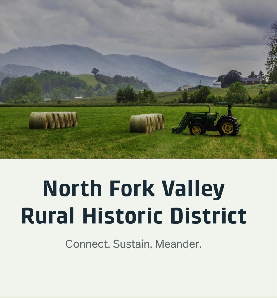
The North Fork Valley Rural Historic District spans nine miles and 10,200 acres in Montgomery County, Virginia. Along scenic Route 785, this ArcGIS tour explores geology, farming, social and architectural history—plus schools and churches—across a multi-generational rural landscape.
The North Fork Valley Rural Historic District spans nine miles and 10,200 acres in Montgomery County, Virginia. Along scenic Route 785, this ArcGIS tour explores geology, farming, social and architectural history—plus schools and churches—across a multi-generational rural landscape.
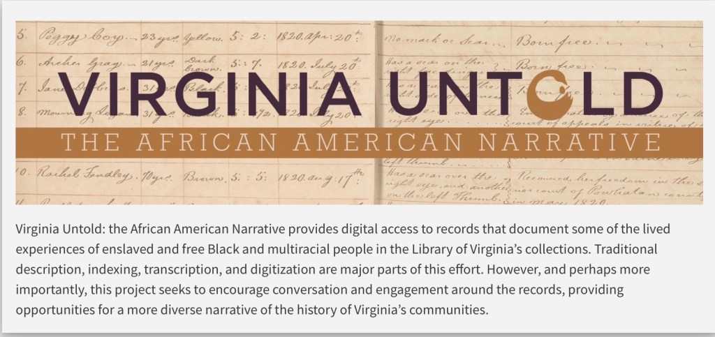
Search the terms “African American” or “enslaved” to uncover information connected to the enslavement of men, women, and children.
Virginia Untold offers a rich online archive of African American history. Search Montgomery and Wythe County records, and use downloadable PDFs for more precise, in-document searching.
Library of Virginia’s Virginia Untold: The African American Narrative provides a comprehensive online archive of African American and related history. These primary sources are invaluable for researchers and genealogists. Search “Montgomery County, VA” to locate local materials, and include “Wythe County, VA,” as some Montgomery County records are held there.
While the site offers search functionality, downloading the PDF transcriptions allows for more targeted searching. For example, a name search will return relevant documents, but locating specific references within them requires opening the PDF and using your browser’s search function. Please note that name spellings may vary.
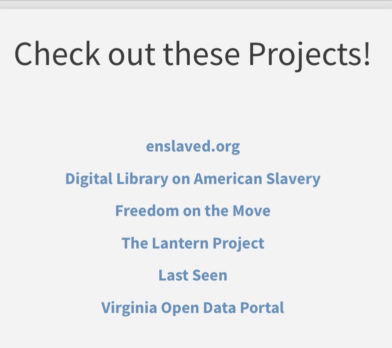
Don’t forget to scroll down the Virginia Untold Search page for additional online resources. Also, the Library holds a huge collection of other online resources that is growing.
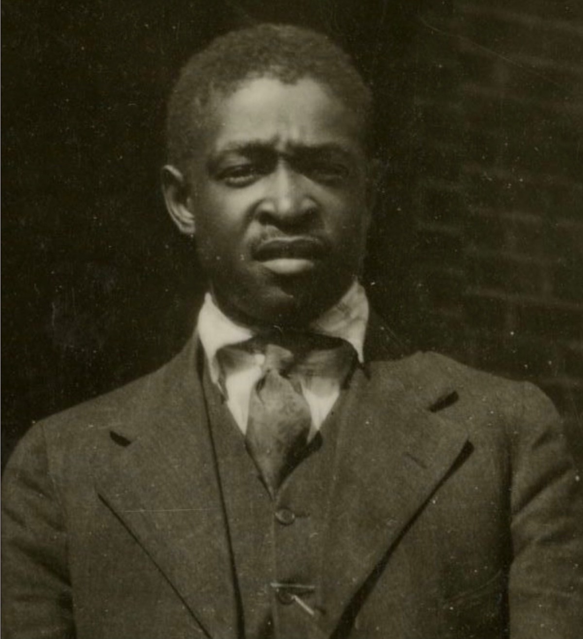
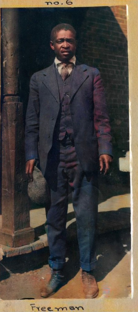
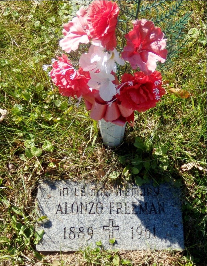
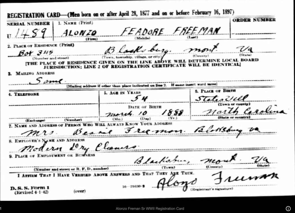
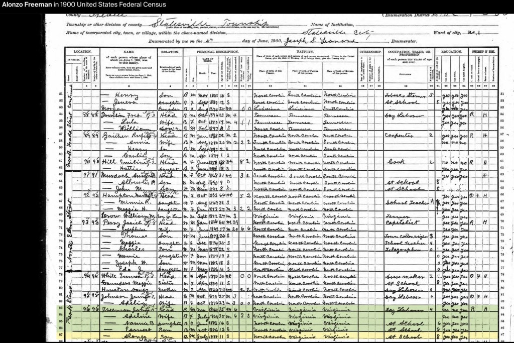
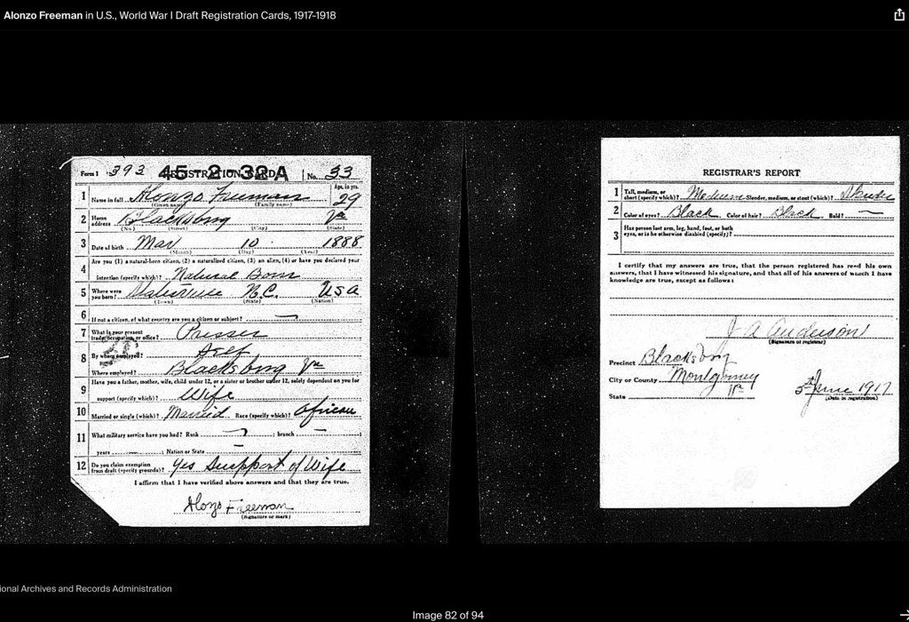
Alonzo Feadore (Fearno) Freeman, Sr. was born on March 10, 1889, in Statesville, North Carolina, to John (b. circa 1864) and Adeline Freeman (b. circa 1864). By the 1900 U.S. Census, John, a day laborer, and Adeline were living with their three children: Nannie B. (b. June 1883), Earnest (b. October 1886), and Alonzo Sr. (b. July 1888, student).
Alonzo F. Freeman (1889-1953)
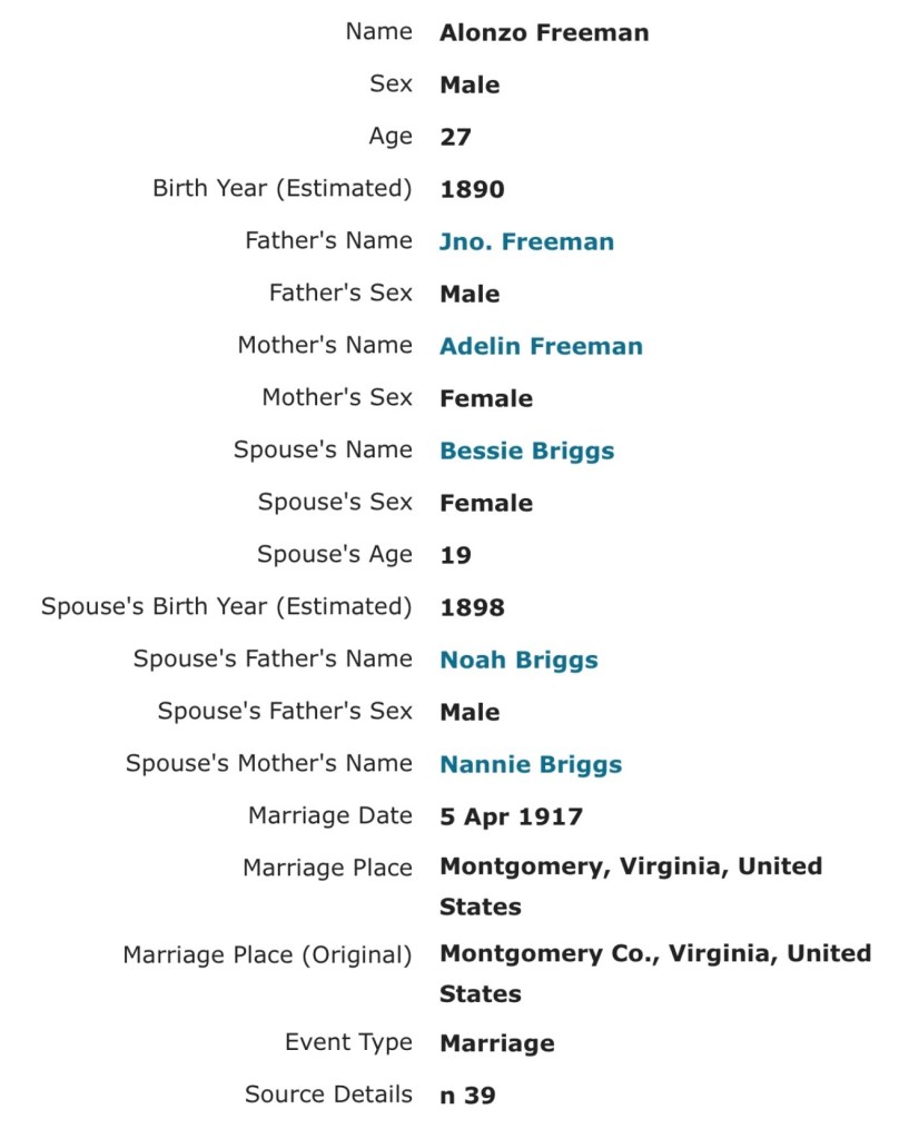
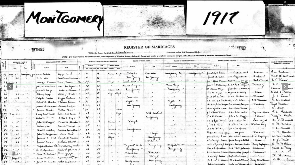
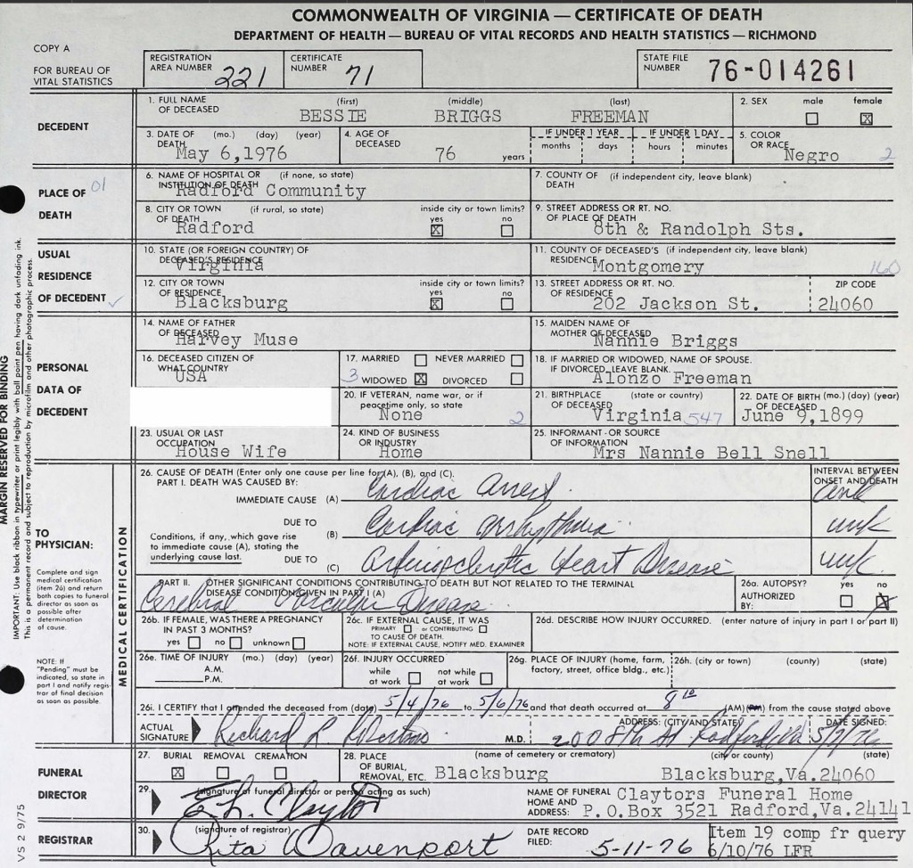
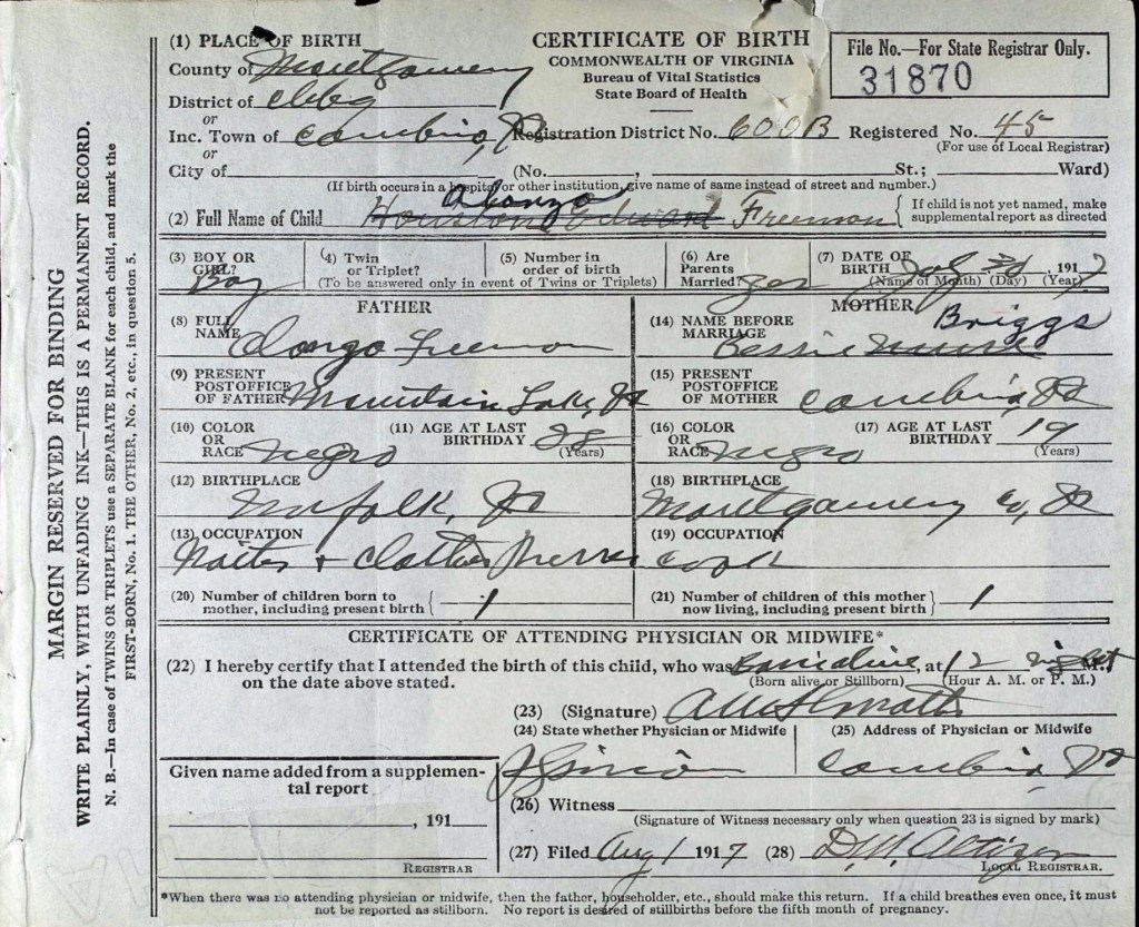
On April 5, 1917, Alonzo married Bessie Virginia Briggs (1899–1976) in Cambria, Virginia. Just a few months later, on July 31, 1917, their first son, Alonzo Freeman Jr., was born in Cambria, Virginia. According to his birth certificate, Alonzo Sr. worked as a waiter and clothes presser at Mountain Lake Resort, Virginia, while Bessie was a cook. During this time, they may have been living with Bessie’s mother and stepfather, who resided near the railroad tracks in Cambria.
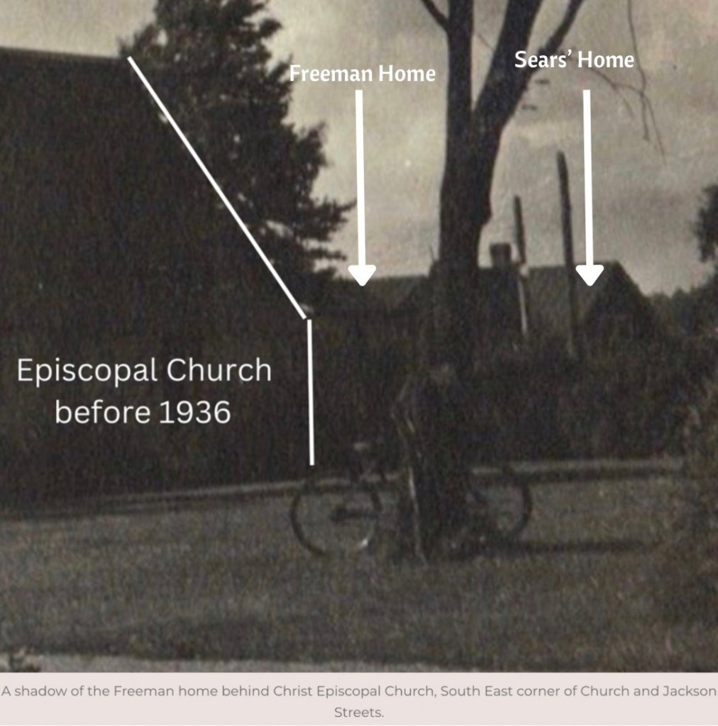
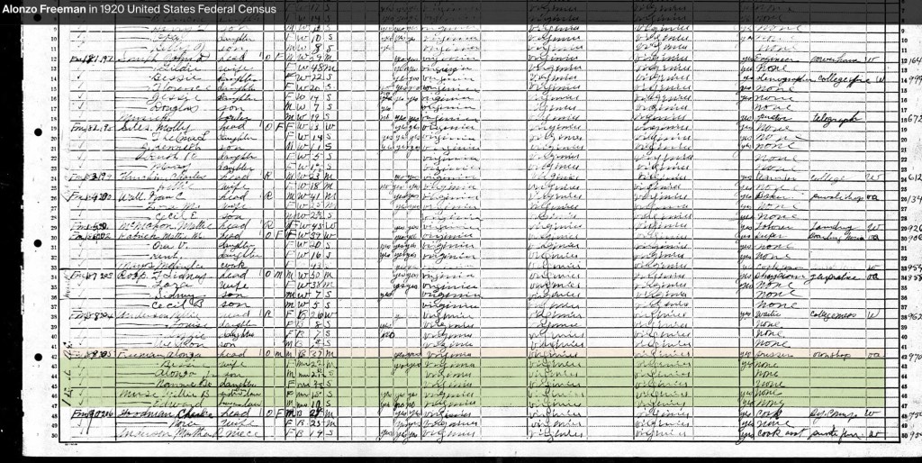
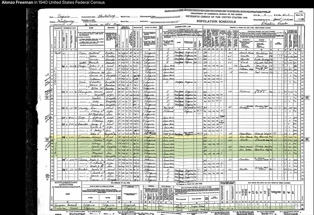
By the 1920 U.S. Census, the Freeman family had settled in Blacksburg, Virginia, on Jackson Street (originally Smithfield Road). Alonzo and Bessie were raising their two children, Alonzo Jr. and Nannie Bell (1919–1987). Also living in the household were Bessie’s siblings, Willie B. Muse and Edward Muse. At this point, Alonzo Sr. owned his home and operated his own pressing and cleaning shop. Their next-door neighbor was Nellie Anderson.
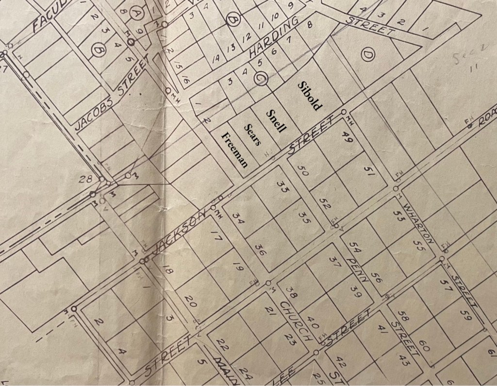
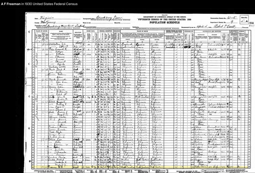
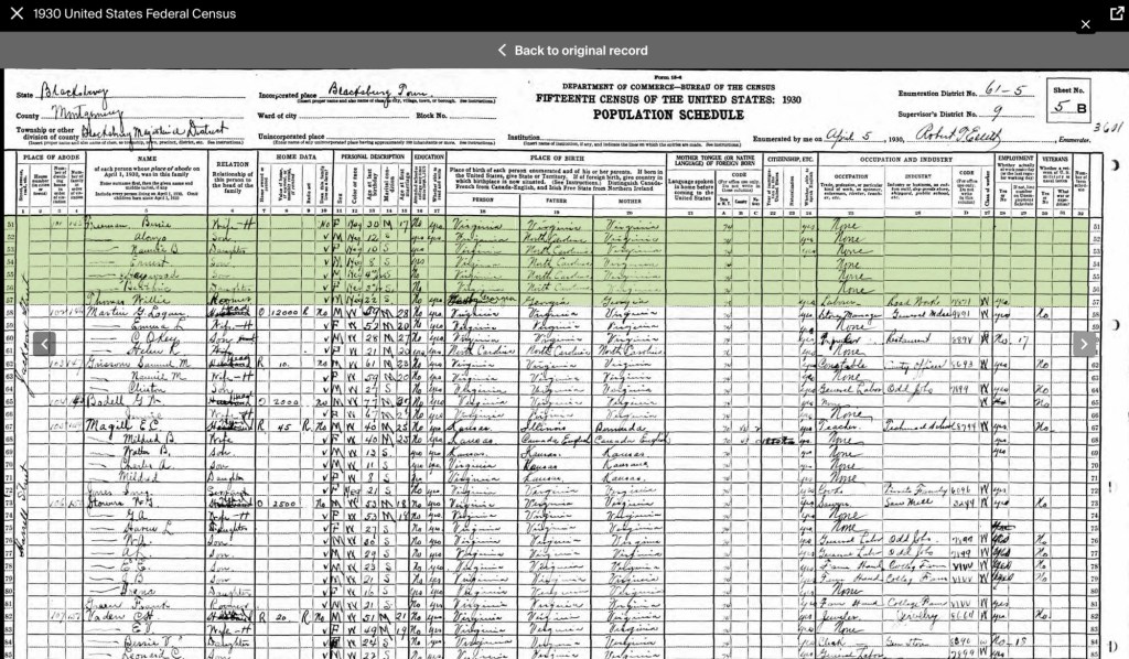
In the 1930s, the Freeman family were living in the same home, now valued at $1,600. They were part of a growing Black community on Jackson and Bennett Streets, surrounded by neighbors such as Wade Sears, Charles Saunders, Lev Collins, John Stolt, Yola Young, Emmett Meade, William Turner, Floyd Meade, Louise Anderson, and Leonard Price. The 1932 Blacksburg City Directory lists Alonzo Sr. as the proprietor of the Blacksburg Press Shop at 302 E. Jackson Street.
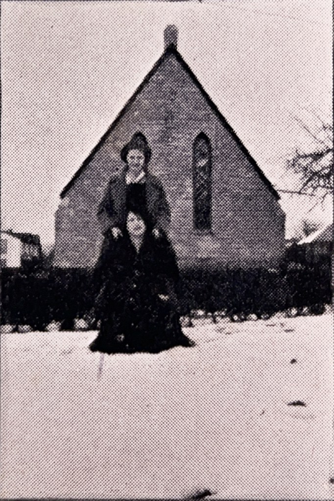
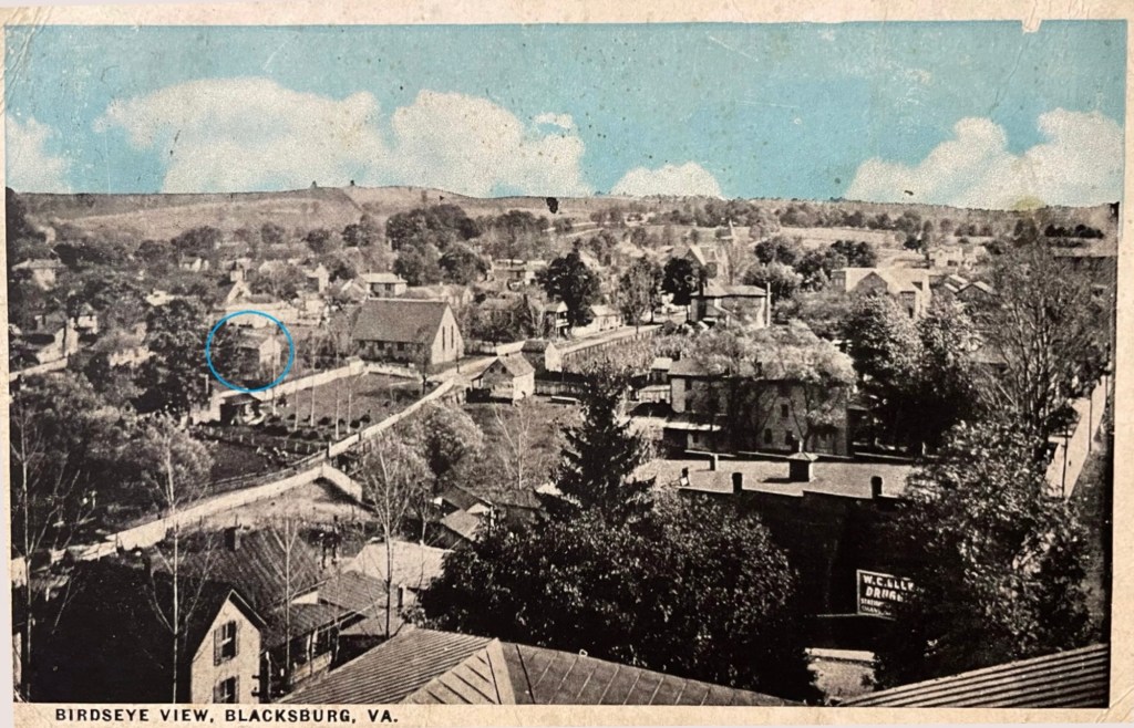
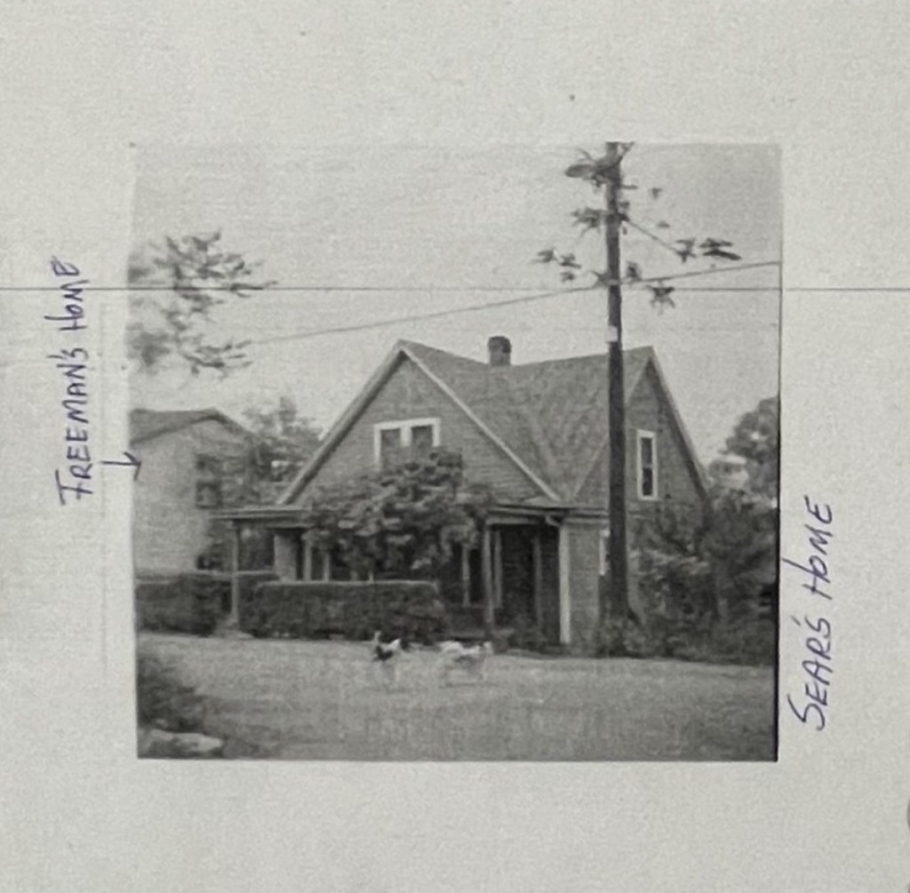
Freeman house is to the left of Christ Episcopal Church, Church and Jackson Streets, prior to 1930s.
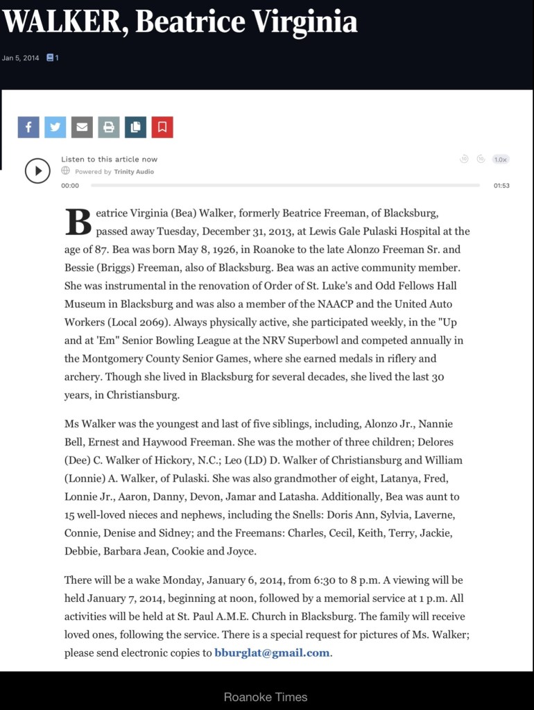
By this decade, the Freemans had expanded their family with three more children: Ernest Linwood (b. 1922), Haywood (1924–1984), and Beatrice (1926–2013). Alonzo Sr. continued to run his cleaning business—the first of its kind in Blacksburg—while Bessie worked for the Episcopal priest, Rev. Richard Martin, and his wife, Jean in the church’s office.
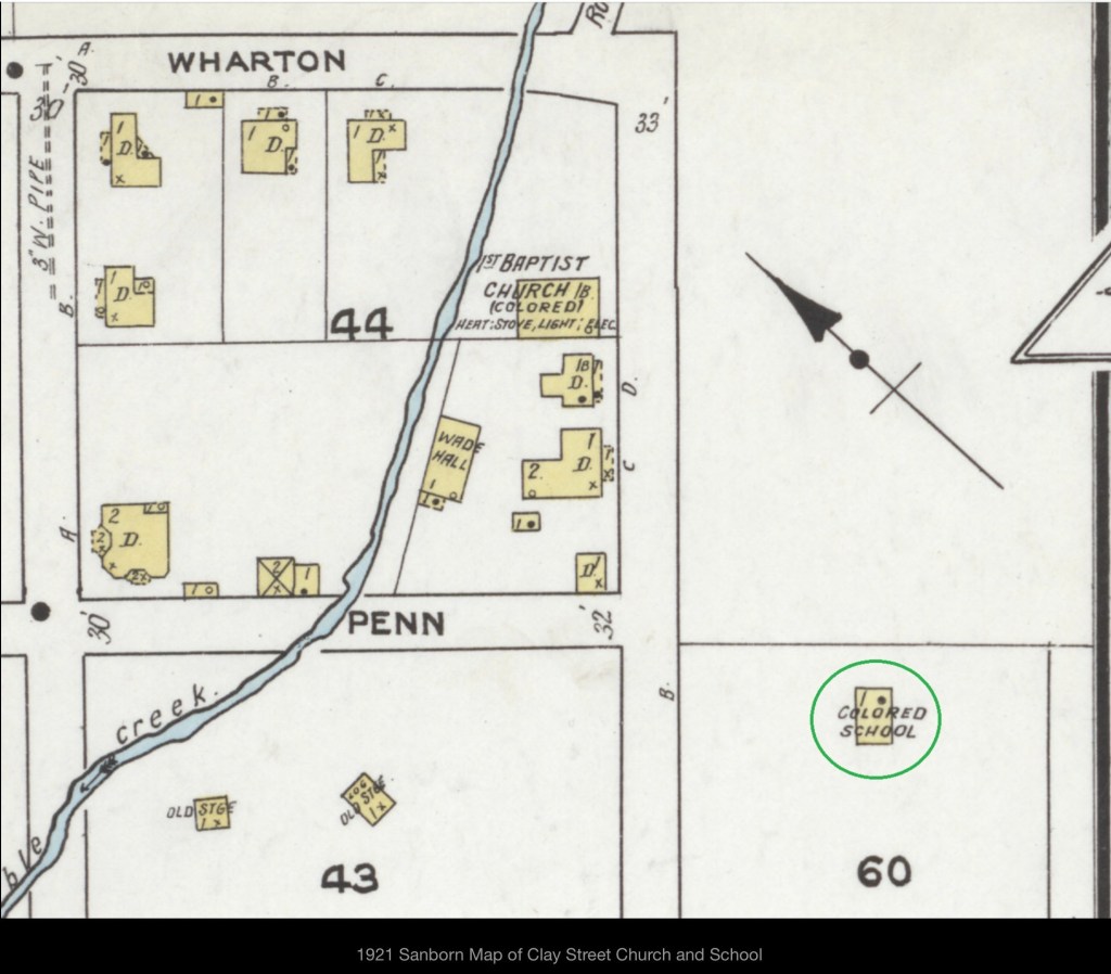
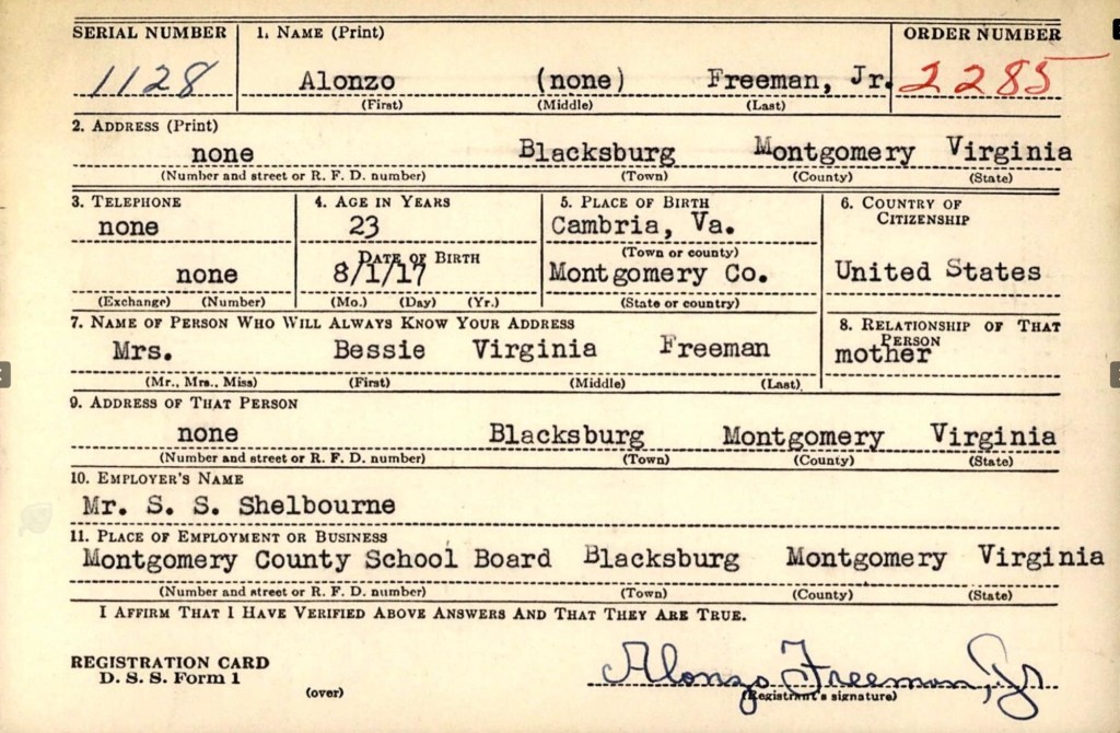
The 1940s marked a pivotal time for the Freeman family, as all the male members registered for the 1942 World War II Draft. These records provided Alonzo Sr.’s full name, Feadore, and documented his business, Modern Dry Cleaners (featured on an early 1950s map of Blacksburg). During this time, Alonzo Jr. served as the principal of the Clay Street Graded School, Linwood worked at the Radford Ordnance Works, and Haywood was employed by Ray Taylor.
1921 Sanborn Fire Map
According to the 1940 U.S. Census, all of Alonzo and Bessie Freeman’s children were still living at home. Nannie Bell worked as a private housemaid, while Linwood was employed as a pin setter at the college bowling alley. Alonzo Sr. continued running his cleaning business, and Bessie worked as a private cook.
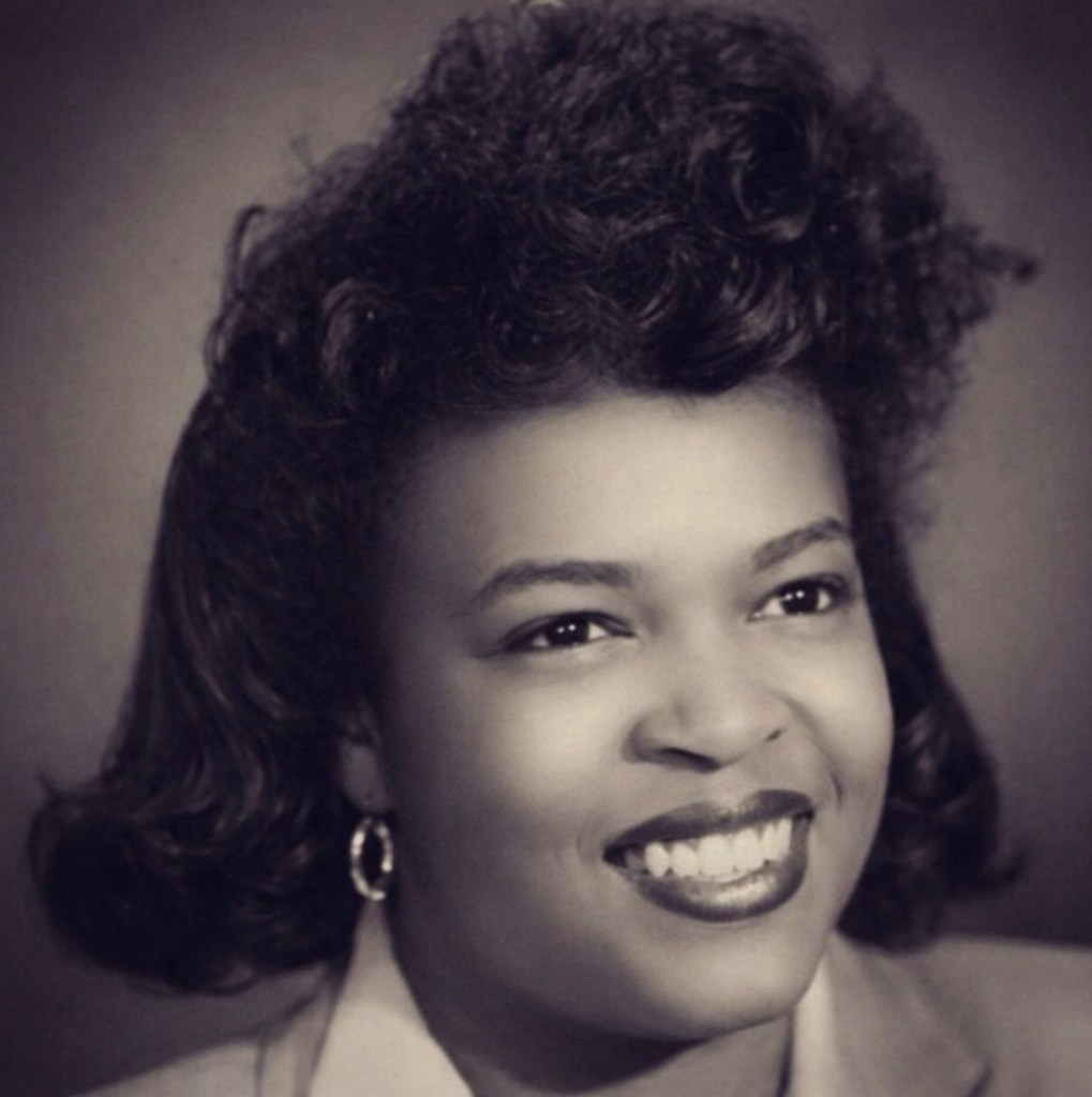
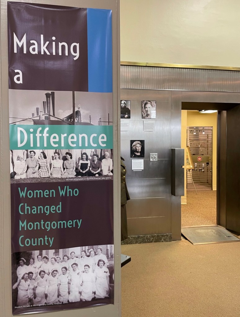
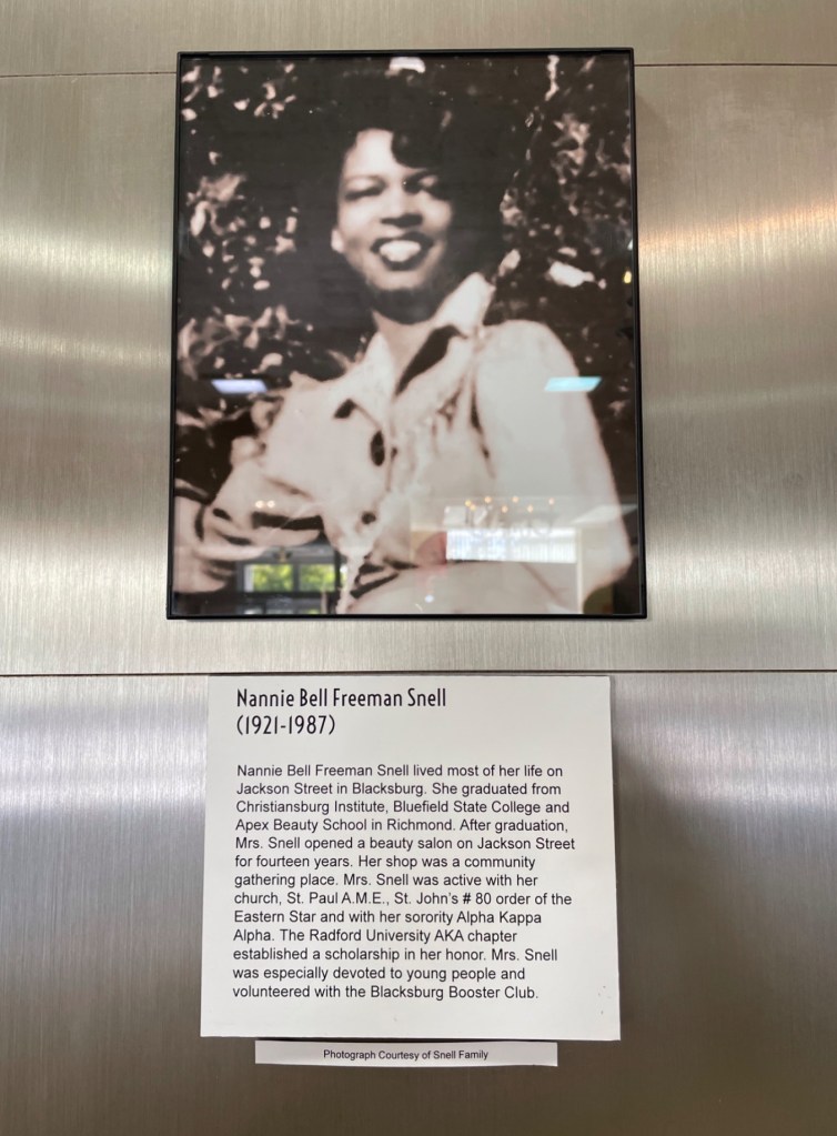
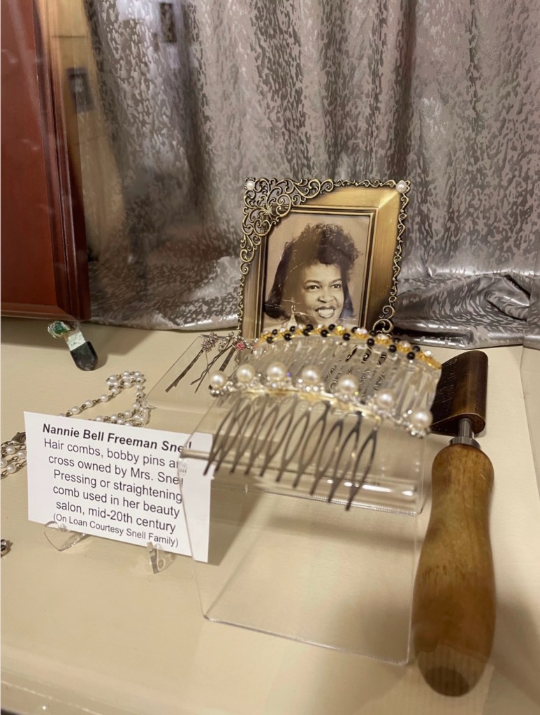
Nannie Bell Freeman Snell (Courtesy of Montgomery Museum of Art & History, repaired image)
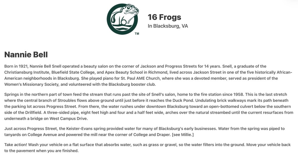
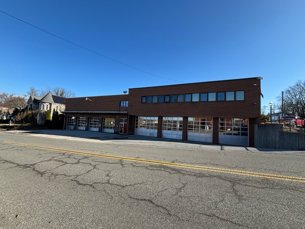
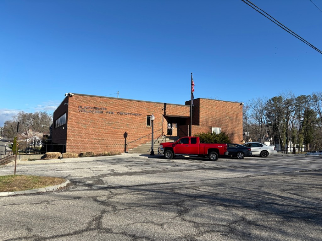
On November 19, 1947, Nannie Bell, now a beautician, married Sidney Grant Snell (1921–1975), a mechanic from Radford. The Snells raised six children and lived at 404 Jackson Street, just down the street from Nannie Bell’s parents, Alonzo and Bessie, who resided at 202 Jackson Street. Only the Snell’s home remains standing today, but the Freeman residence was located at the same corner of Jackson and Progress Streets where the town’s 1958 firehouse now stands. Blacksburg named a frog to honor Nannie Bell.
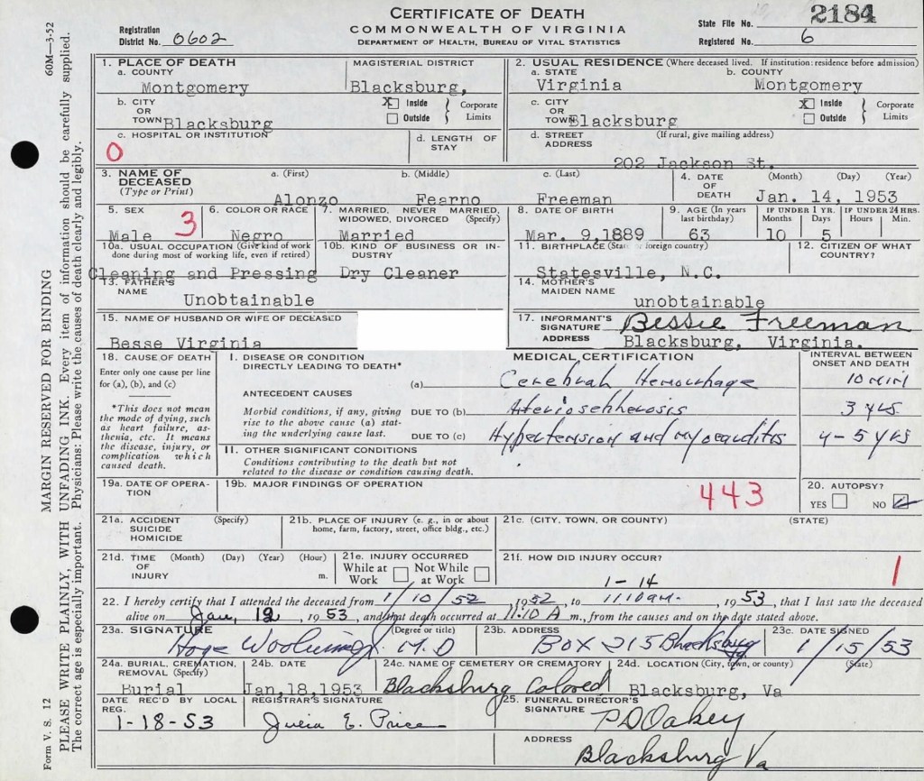
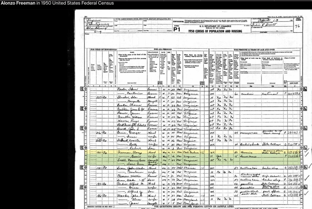
By the 1950 U.S. Census, Alonzo Sr., now in his 60s, was working at Virginia Polytechnic Institute’s Cleaning Plant. Nannie Bell and her daughter, Doris Ann, were living with her parents at the family home. By this time, all three Freeman sons had moved to Washington, D.C., with Linwood living alongside Haywood. Alonzo Jr. had married and was serving as the principal of the Clay Street segregated school before becoming the principal of an elementary school in Baltimore.
Bessie Virginia Briggs Freeman (1899 to 1976)
Bessie’s mother, Nancy Sweeney, was born in 1872 in Christiansburg, Virginia. Her father, Noah Briggs, was the son of George and Jane Briggs. Nancy and Noah were married on February 14, 1894. By the 1900 Census, the Briggs, Green, and Sweeney families—several generations of the same extended family—were living as neighbors in Cambria.
By the 1910 Census, Nancy Sweeney Briggs had married Harvey (Harry) Muse of Cambria, a laborer at the lime kiln. Together, they had four children: Willie B. (b. 1902), Grace (b. 1904), Connie (b. 1906), and Edward (1909–1950). Edward Muse later married Bessie Lynch (b. 1911), and they settled in New Town, where they raised five children: Jean (b. 1932), Constance (b. 1934), Shirley Ann (b. 1936), Edward Jr. (b. 1938), and Harold A. (b. circa 1940). By 1940, Edward Muse was working at the Virginia Polytechnic Institute Monogram Presser Plant alongside his neighbor, John Green, and Alonzo Freeman Sr.
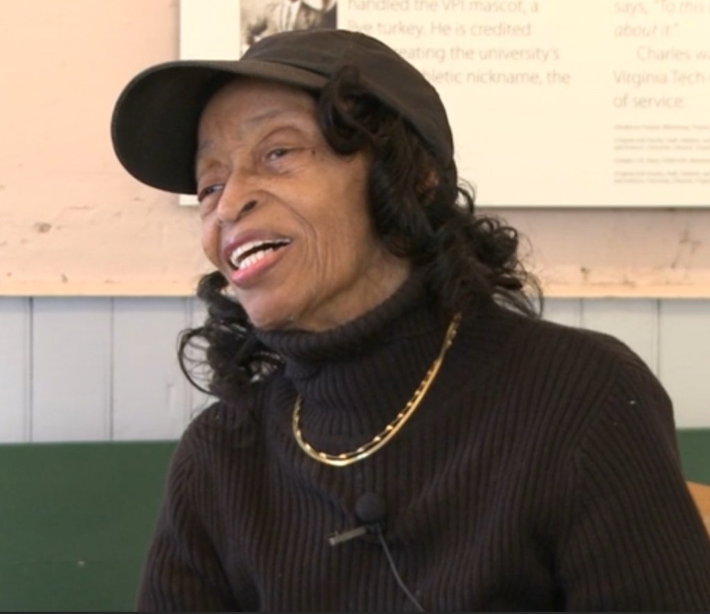
In 2013, Beatrice Freeman Walker, the youngest daughter of Bessie and Alonzo Freeman, participated in an oral history interview now archived at Virginia Tech University Libraries. In this interview, she shared valuable insights into her mother’s work in the homes of prominent community members and her leadership in the Independent Order of St. Luke’s (St. Frances Council #235), which operated out of the shared building in New Town alongside the Odd Fellows and the Household of Ruth. Beatrice also highlighted her mother’s important role in coordinating the return of soldiers for family funerals through the Red Cross.
Beatrice Freeman Walker (courtesy of Virginia Tech University Libraries)
Additionally, the interview sheds light on her father, Alonzo Freeman Sr., and his contributions to the Black community in Blacksburg. Among these was his creation of a weekend retreat for African Americans, called Paradise View, located on land he owned off Grissom Lane—now known as Nellie’s Cave. Beatrice’s recollections provide a crucial window into the history of Black life in Blacksburg and the legacy of her parents.
Notes to Further Explore – Mountain Lake Connection
In her book Kentland at Whitethorne (Walpa Publishing, Blacksburg, VA, 1995), historian Patricia Givens Johnson mentions a “Mrs. Freeman,” who worked as a chambermaid at Mountain Lake Hotel shortly after emancipation. According to Johnson (p. 53), Mrs. Freeman married Bob Jackson, who had been enslaved by James Randal Kent (1792–1867), the owner of Kentland Plantation. Some of their children took the Jackson surname, while others retained the Freeman name. Johnson identifies their children as Flemish Jackson, Bessie, Bob, Qu, and Irene Freeman, noting that they were employed by the hotel well into the 1900s.
This connection warrants further research, but it raises an interesting possibility—when Alonzo Freeman married Bessie Briggs in 1917, he was working at Mountain Lake Hotel as a waiter and clothes presser. Could this employment have been influenced by family ties to the hotel? Further exploration may help clarify the Freeman family’s long-standing connection to Mountain Lake.
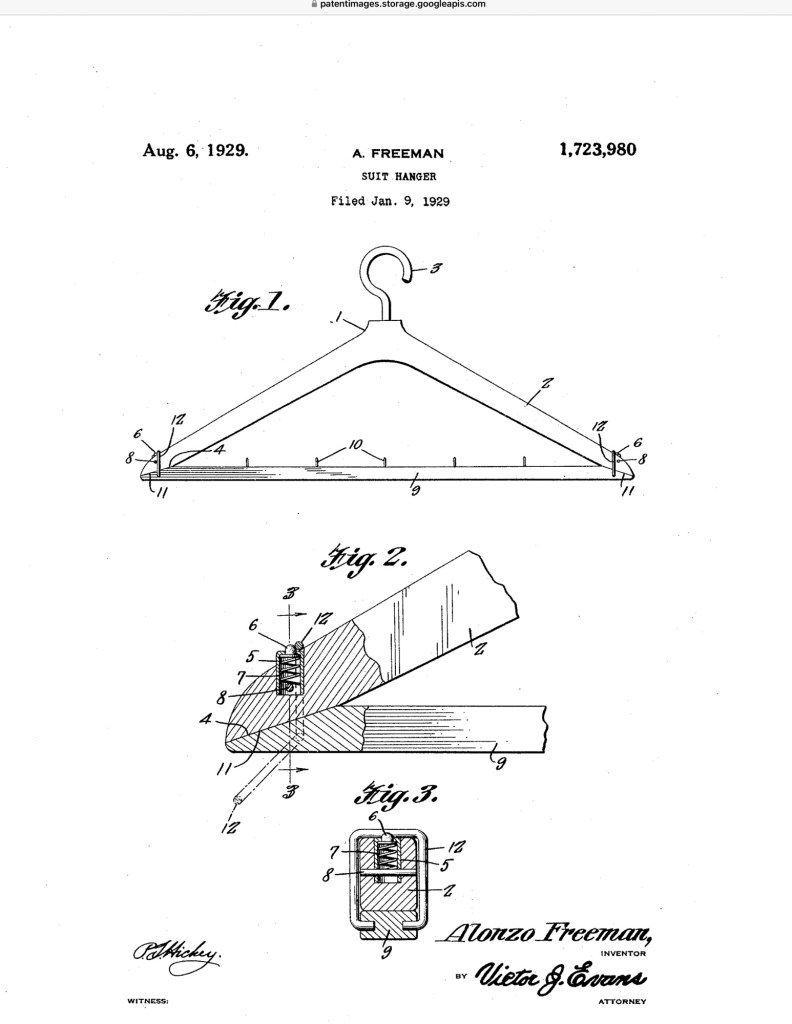
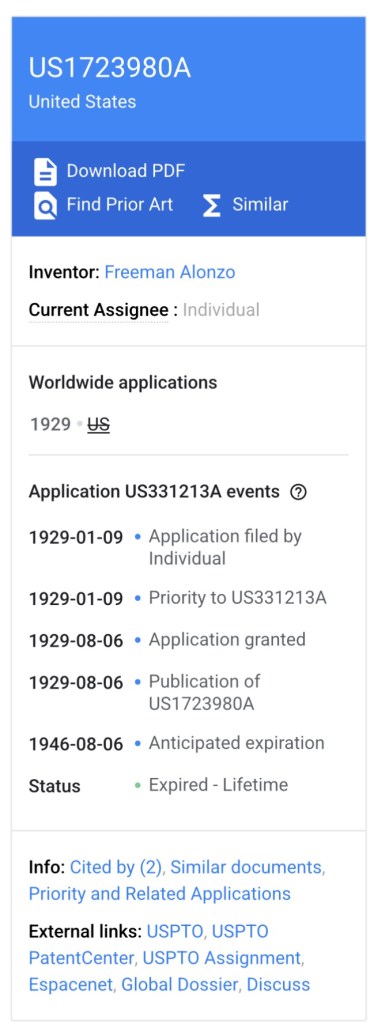
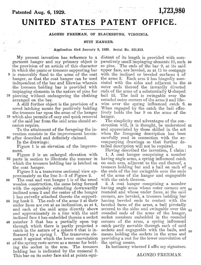
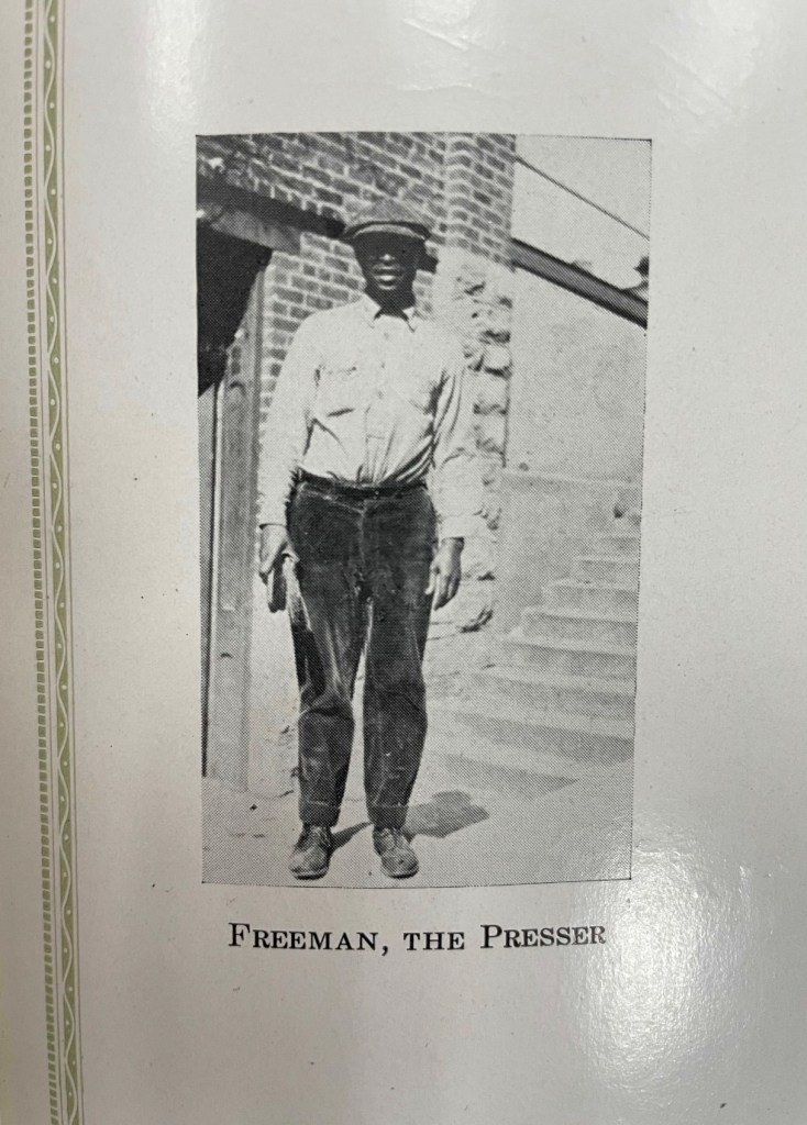
In the winter of 1929, in Blacksburg, Virginia, Alonzo Freeman did something remarkable. While running his clothes-cleaning business during the era of government sanctioned segregation, he took time to solve a practical problem he faced every day.
Working with coats, suits, and trousers, Freeman designed a better garment hanger. His invention included a removable bar for trousers and a simple latching mechanism that held the bar securely in place while still allowing it to be quickly removed.
On January 9, 1929, Freeman filed for a patent with the United States Patent and Trademark Office. Later that year, on August 6, he was granted U.S. Patent 1,723,980.
Freeman’s hanger is a reminder that innovation often grows out of everyday work. Even in the face of segregation, Black entrepreneurs and tradesmen were imagining new ideas, improving tools, and shaping their communities.
Gallery
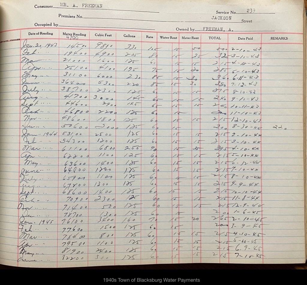
Location of the Freeman’s Home (postcard of Blacksburg prior to 1913, courtesy of Jody Booze-Daniels)Map of Blacksburg prior to 1957 with the families noted. Freeman’s home located west of Wade Sears’ Home prior to 1957, date the firehouse was built. (Martha Shupp Phillips masters thesis, 1948, VPI)The two houses in the background.The Freeman’s home is behind the church (people unknown) to the left of the image. The 1940s town water payment ledger (courtesy of BMCF)West-facing façade of Blacksburg Fire Station #1. The original 1957–58 building appears on the left side of the image, marked by the smaller doors. The Freeman family home once stood on the site where the newer vehicle bays are now located.South-facing façade of Blacksburg Fire Station #1, on the site where the Freeman family’s home once stood.North-facing façade of Blacksburg Fire Station #1. The original 1957–58 building extended about halfway along the brick wall that runs parallel to Stroubles Creek, near the location of Nannie Bell’s frog.Alonzo Freeman, Sr from 1922 Bugle Yearbook. Alonzo Freeman, Sr (source unknown) Freeman family Lee Street Cemetery (now called Southview Memorial Gardens)Alonzo Feadore Freeman WWI registration card. Alonzo Freeman Death CertificateAlonzo and Bessie Marriage Record information.Alonzo and Bessie Marriage Record 1917Alonzo Freeman in Statesville, NC in US Census 1900.Freeman family in Blacksburg, Va on Jackson St (1st St) in US Census 1920Freeman family in Blacksburg, Va on Jackson St (1st St) in US Census 1930Freeman family in Blacksburg, Va on Jackson St (1st St) in US Census 1930. Willie Thomas included, boarder. Freeman family in Blacksburg, Va on Jackson St (1st St) in US Census 1940. Freeman family in Blacksburg, Va on Jackson St (1st St) in US Census 1950Bessie Briggs Freeman obituaryBeatrice Freeman Walker obituaryAlonzo Freeman, Jr WWII registration cardAlonzo Freeman, Jr birth certificateNannie Bell Freeman Snell was featured in a 2022 exhibit at the Montgomery Museum of Art & History titled “Making a Difference: Women Who Changed Montgomery County.” The exhibit recognized women whose leadership, work, and community impact helped shape the history of Montgomery County.Nannie Bell Freeman Snell was featured in a 2022 exhibit at the Montgomery Museum of Art & History titled “Making a Difference: Women Who Changed Montgomery County.”Nannie Bell Freeman Snell was featured in a 2022 exhibit at the Montgomery Museum of Art & History titled “Making a Difference: Women Who Changed Montgomery County.”Alonzo Freeman, Sr WWI registration Card
Hidden Histories: Family Stories Beyond Montgomery County
When researching local history, we often come across carefully documented African American family histories that have no direct link to Montgomery County, Virginia. These stories are too valuable to leave hidden.
This page will share those findings so they might reach descendants searching for their past. Even without local ties, they speak to the wider story of resilience, migration, and community.
If you recognize a name or place, we invite you to connect—your memory could help bring another family’s history to light.
BRUMMAGE FAMILY
Brumage-Brummage Family, They are the same family, Monongalia and Marion Counties, West Virginia, Virginia Brumage Wakeman. Montgomery Museum of Art and History, Christiansburg, VirginiaBook is in the possession of Montgomery County Museum of Art and History.Passage transcribed belowClarence BrumageClarence Brumage
During our research on the Brumage family, we visited with the Clarence Brummage family in Homestead, FL. We were warmly greeted and all the information he could recall was told to me.
On our return to California, I stopped at the Morman Library in Salt Lake City to see what records could be found and how far back I could take the family. I will start with the family of Clarence.
Clarence Brummage was born 16 June 1920 in Cochran, Georgia. His father was Tom (Booten) Brummage and his mother was Josephine Clark. Clarence was in the army during World War II. He married Everlena Trammeall, 31 October 1950 in Collins, Georgia. Daughter of Roy Trammeal, Everlena was born 16 March 1926 and was killed in a car accident 3 November 1977 in Homestead, FL.
Clarence and Everlena had nine children: Clarence Jr., b. 3 October 1952, Jeanette, b. 17 January 1956, Evelyn Ann, b. 26 April 1957, Ina Mae, b. 26 May 1958, in Cochran, Georgia, Dwight Wayne, b. 16 January 1961, Decatur, Alabama, Dorothy Jean, b. 7 August 1962, Pensacola, Florida, Michael Anthony, b. 9 March 1964, Daytona Beach, Florida, Josephine, b. 14 September 1965, Miami, Florida, and Donald Lee, b. 1 March 1968, Miami, Florida.
Clarence said he was raised by Dornest (Donna) Grandhoun and that she gave him the name of Brummage. Tom (Booten) Brummage worked for John Anderson in Cochran and Clarence remembers him as being 7 ft. tall.
Clarence has a sister, Sarah Lee Brummage Kemp who lives in Cochran. His mother Josephine Clark died in Florida. Josephine’s mother’s name was Sarah Woodfork and they all attended the Mt. Zion Baptist Church in Cochran.
On the 1900 census in Pulaski County (later changed to Beckley County in 1912 [Georgia]) Georgina Brummage, b. October 1854 is listed with sons Miles, b.March 1882 and Thomas, b. November 1890. I am assuming that Thomas is the father of Clarence. They were living in the Colhran district. Also in the same area is Hannah Jackson, b. 1867, her children were Wilson Brummage, b. November 1883, Lou Brummage, b. June 1885 and Charity Brummage, b. July 1888.
The family of Charley Brummage, born December 1877, his wife Zilla, b. June 1876, and their daughter Vinie, b. September 1899. This family lived Della Brummage, age 37, b. January 1863. Her children Anna Lee, b. April 1896. They lived in Hawkinsville.
1882, Lizzie, b. August 1885, John b. November 1887, Jeffries, b. November. In Ward County, Georgia, I found Amie Brumage with sons David, Henry, Bogene, and daughters Neppie, Nora and Lulu E.
1990 census was burned so I next read the 1880 census. On this census I found the following. Trank Brummage, age 25, living in Pulaski County, he was working for Reuben Waters. Frank was single, a laborer, maimed, crippled or disabled, could not read or write, his parents were born in Georgia. There were no Brummages listed in Pulaski County in 1870 or 1860 so where Frank Brummage obtained the name of Brummage is a mystery. At least I found Tom (Booten) Brummage. I had hoped to find where this family, at one time, were slaves to a Brummage family but I could not find any proof of this.
I did call a James Brumage in Newport, Virginia and he was also black. He did not know where he obtained the name of Brumage.
Someone with the name of Brumage/Brummage had to be in the area during the Civil War or shortly afterward for the name to be taken by the families I found.
The Formation of Montgomery County, Virginia and Why it Matters to Regional African American History
When Virginia’s earliest European colonial settlers first pushed westward beyond the Blue Ridge Mountains, they entered the border lands already inhabited by Indigenous peoples for thousands of years. As Europeans laid claim to these territories in the 18th century, Virginia’s county boundaries began shifting rapidly to keep pace and the need for local governance.
At first, all of western Virginia was considered part of vast counties based far to the east. Augusta County, created in 1738, stretched from the Blue Ridge to the Mississippi River—a landmass so large it was nearly impossible to govern effectively. As settlement expanded, Augusta was gradually carved into smaller counties.
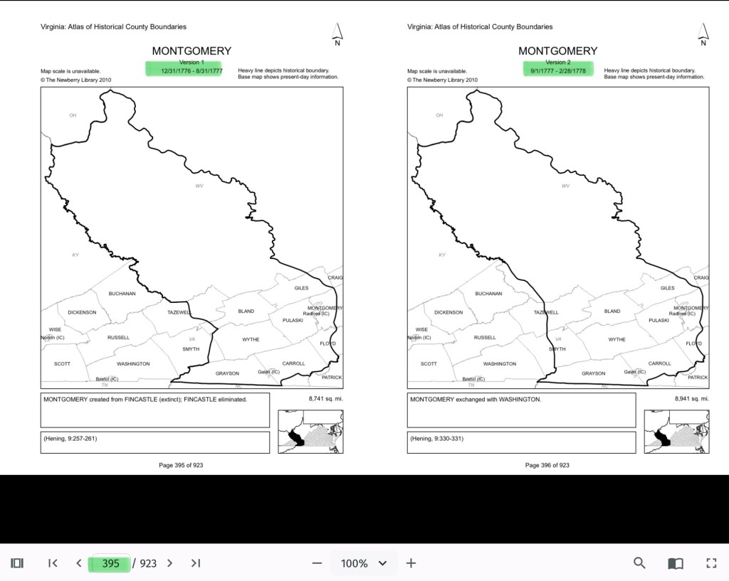
Botetourt County was created in 1770 out of Augusta, and just two years later, in 1772, Fincastle County was formed to cover the far southwest. But Fincastle itself was short-lived: in 1776, it was split into three new counties—Montgomery, Washington, and Kentucky (the latter eventually becoming the Commonwealth of Kentucky).
Thus, Montgomery County was officially established in 1776, named in honor of General Richard Montgomery, a Revolutionary War hero.
Like most early counties, Montgomery did not remain the same size for long. As population grew and communities demanded closer courts and local representation, Montgomery’s original boundaries were gradually reduced.
1790: Wythe County was formed from Montgomery. 1790: Parts of Montgomery contributed to the creation of Kanawha County (now in West Virginia). 1806: Giles County was carved from Montgomery, Monroe, Wythe, and Tazewell. 1806–1830s: Additional shifts continued, with Montgomery giving land to Floyd (1831), Pulaski (1839), and others.
By the mid-19th century, Montgomery County had taken on the approximate shape we recognize today.
Why this matters
Tracing these changing boundaries shows how the western border lands of Virginia evolved from a vast Indigenous landscape into the network of counties we know today. When we study Montgomery County’s formation and its changing borders, we are not only tracking political geography—we’re also uncovering how those shifts shaped the daily realities of enslaved people and freedmen. The “line on a map” often meant the difference between where families were recorded, where they could live, and how they could begin to claim freedom and opportunity.
County seats like Christiansburg were not only centers of trade and government but also the location of the slave market and the courthouse records that tracked the lives of enslaved people. After emancipation, those same courts became the places where freedmen registered marriages, secured contracts, and sought land. As county lines shifted, so too did the jurisdictions that controlled access to justice, opportunity, and community life.
Further Discussion on How Shifting Boundaries Change Lives
Laws & Records
When county boundaries changed, so did the courthouse where records were kept. For enslaved people, this meant that bills of sale, wills, deeds, and manumission papers might end up filed under different counties as the boundaries shifted. After emancipation, the same was true for marriage licenses, labor contracts, and land purchases by freedmen. This scattering of records makes it both complicated when tracing family histories.
Shaping Community, Labor & Education
County lines determined where enslaved people were forced to labor, where patrols were organized, and where courts enforced slavery laws. After emancipation, those same boundaries shaped freedmen’s access to work, land, and schools. For example, as new counties like Giles or Pulaski were created from Montgomery, Freeman might find themselves suddenly in a different jurisdiction, dealing with a new local power structure.
Education also reflected these divisions. Freedmen near Christiansburg had better access to schools supported by the Freedmen’s Bureau, while those in rural reaches of the county received little help.
Courts and Law
During slavery, county seats (like Christiansburg) were centers of trade, law, and the slave market. Enslaved people were taken to county courts for sales, trials, and punishment. After emancipation, those same county seats became the centers where freedmen registered marriages, secured legal recognition, and later sought protection under Reconstruction policies.
Land, Freedom, and Mobility
For freedmen, land ownership was key to independence. But access to land varied widely from one county to another, depending on who owned large estates, which lands were subdivided, and how local officials treated Black landholders. County boundaries thus shaped the possibilities of building self-sustaining communities after emancipation.
This searchable document is a rich source of information about the county and its wider connections. For example, it notes that the New River boatmen once lived on Kent Farm, where they were enslaved by James Randle and Margaret Cloyd Kent prior to emancipation (see page 13). Additional details about Kentland and these freedmen can be found in the following postings: Historic Kentland and Historic Wake Forest
The names of some of the black boatmen of 19th-century Montgomery County include Frank Bannister (who was a boatman on the James River before the Civil War), Calvin Bannister, Roland Stuart, George Brown, and Lewis Smith.
This report that was written by Gibson Worsham, Dan Pezzoni, Charlotte Worsham, David Roenizer, and others. It addresses the following: 1) Overview of the county’s history, 2) A comprehensive inventory of significant structures and sites in the county and 3) Maps delineating the location of said structures and sites. Similar to the report above, this is a wealth of information about the county.
The Formation of Montgomery County, Virginia and Why it Matters to African American History of the Region
When Virginia’s earliest European colonial settlers first pushed westward beyond the Blue Ridge Mountains, they entered the border lands already inhabited by Native peoples for thousands of years. As Europeans laid claim to these territories in the 18th century, Virginia’s county boundaries began shifting rapidly to keep pace and the need for local governance.
At first, all of western Virginia was considered part of vast counties based far to the east. Augusta County, created in 1738, stretched from the Blue Ridge to the Mississippi River—a landmass so large it was nearly impossible to govern effectively. As settlement expanded, Augusta was gradually carved into smaller counties.
Botetourt County was created in 1770 out of Augusta, and just two years later, in 1772, Fincastle County was formed to cover the far southwest. But Fincastle itself was short-lived: in 1776, it was split into three new counties—Montgomery, Washington, and Kentucky (the latter eventually becoming the Commonwealth of Kentucky).
Thus, Montgomery County was officially established in 1776, named in honor of General Richard Montgomery, a Revolutionary War hero.
Like most early counties, Montgomery did not remain the same size for long. As population grew and communities demanded closer courts and local representation, Montgomery’s original boundaries were gradually reduced.
1790: Wythe County was formed from Montgomery.
1790: Parts of Montgomery contributed to the creation of Kanawha County (now in West Virginia).
1806: Giles County was carved from Montgomery, Monroe, Wythe, and Tazewell.
1831: Montgomery giving land to Floyd
1839: Montgomery giving land to Pulaski
1892: City of Radford
By the mid-19th century, Montgomery County had taken on the approximate shape we recognize today.
Why This Matters
Tracing these changing boundaries shows how the western border lands of Virginia evolved from a vast Indigenous landscape into the network of counties we know today. When we study Montgomery County’s formation and its changing borders, we are not only tracking political geography—we’re also uncovering how those shifts shaped the daily realities of enslaved people and freedmen. The “line on a map” often meant the difference between where families were recorded, where they could live, and how they could begin to claim freedom and opportunity.
County seats like Christiansburg were not only centers of trade and government but also of the slave market and the courthouse records that tracked the lives of enslaved people. After emancipation, those same courts became the places where freedmen registered marriages, secured contracts, and sought land. As county lines shifted, so too did the jurisdictions that controlled access to justice, opportunity, and community life.
The flip book of maps below is a helpful resource to understand how the boundaries changed with time. Begin on page 395.
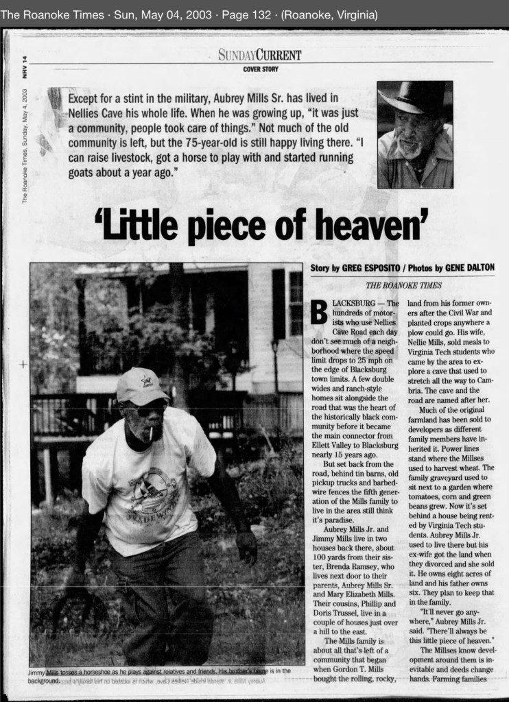
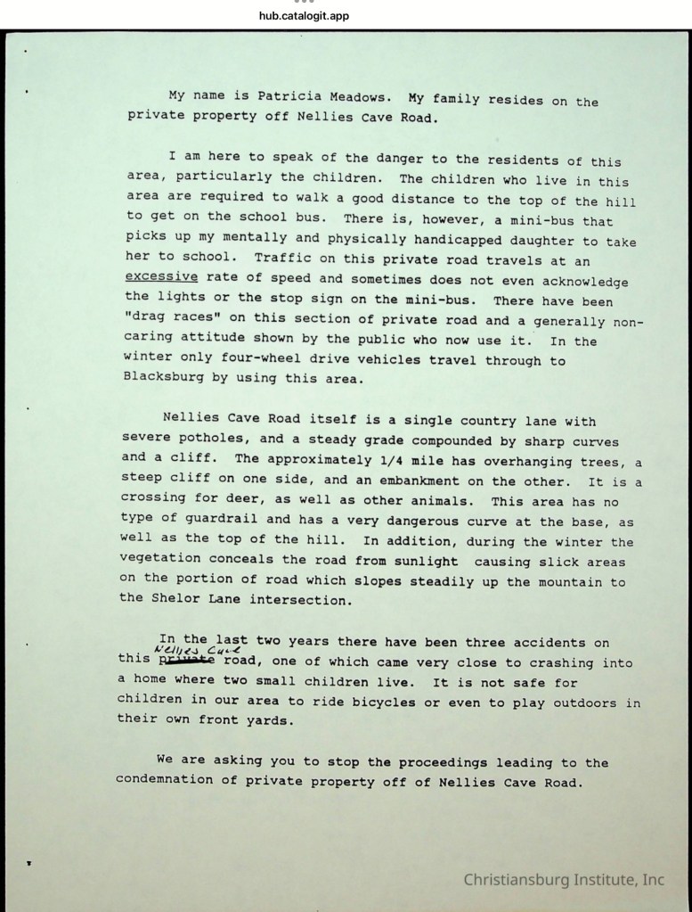
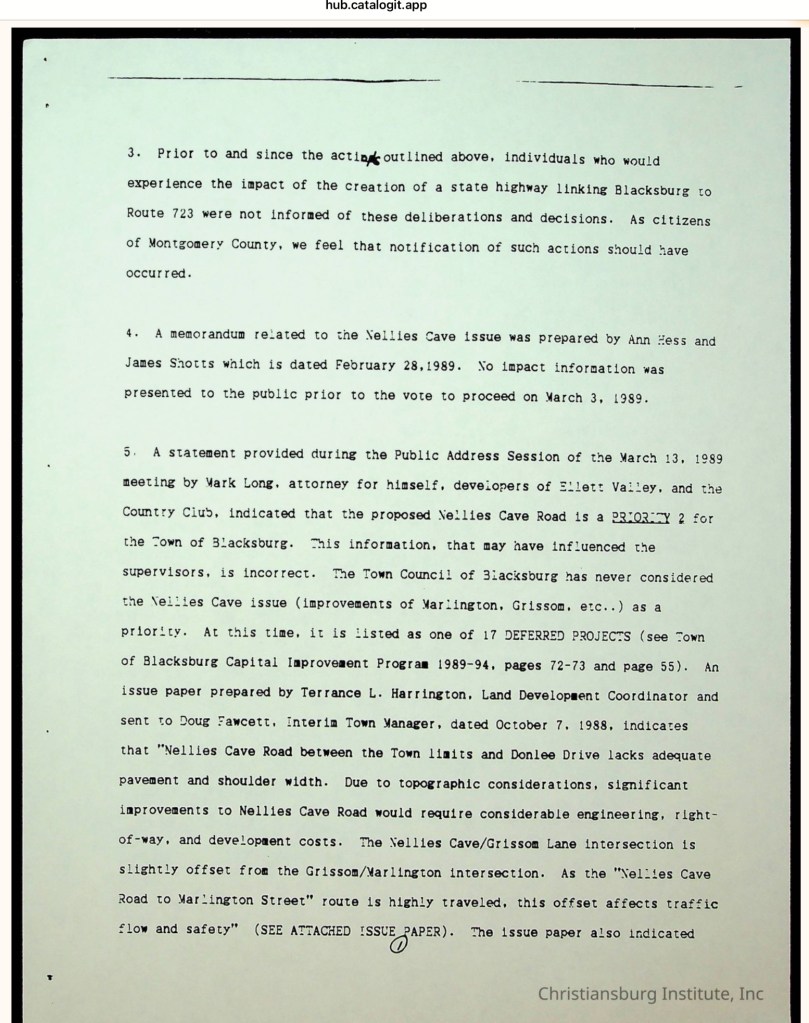
Southeast of the Town of Blacksburg, on the eastern side of the Allegheny Mountains, a community of African American families took root in the early 20th century when the Mills family purchased 40 acres from the Hoge family. For generations, these families farmed the land, raised children, and built their lives in this secluded karst landscape. The unpaved lane that served them was not called Nellie’s Cave Road until the 1980s, when Montgomery County officially named it. Before then, the residents knew it simply as Grissom Lane. The old farm road began at the Slusher family’s farm—located at the southeast corner of South Main Street and Country Club Drive—and ended where the terrain became too steep for a wagon to pass.
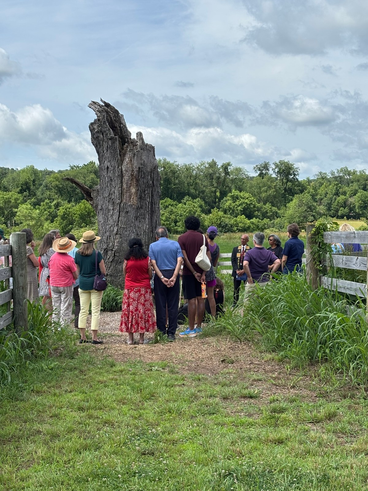
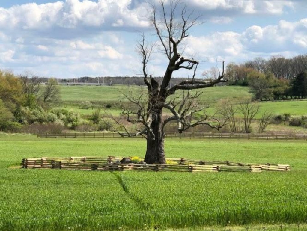
The Merry Tree, now a broken and weathered stump southeast of the Preston home, once stood as a silent witness to over a century of enslavement. It remains a sacred place where descendants return to honor their ancestors. We are gathering stories, photos, and memories connected to this tree. Let’s preserve its powerful legacy.
Help Us Tell the Story of the Merry Tree
For over a century, the Merry Tree stood as a silent witness to the lives of the 226 people enslaved by the Preston family at Smithfield, Blacksburg, Virginia. Planted near the time the Prestons built their home, this tree bore witness to generations of forced labor, family separation, resistance, and endurance. Though now reduced to a broken and weathered stump, the Merry Tree remains a place of deep meaning—especially for the descendants of those once enslaved, who return here to remember, honor, and reflect.
We are seeking to gather as much information, memory, and meaning as possible about this special tree. Did your family speak of it? Do you have photos, stories, or oral history connected to the Merry Tree? Whether you are a descendant, community member, or researcher, your voice matters in helping us preserve and understand the role this sacred place played in Black history in Montgomery County.
Please share what you know. Together, we can ensure the story of the Merry Tree—and those who stood beneath it—is never forgotten.
This enormous sycamore stands just east of the spring that once provided potable water for the people living on the Smithfield property. The spring lies a considerable distance from the house and closer to the old Merry Oak. One can only imagine the countless gallons of water enslaved people carried from that spring to the white house on the knoll over nearly a century. Like the Merry Tree, this sycamore may have held significance for the men, women, and children forced to labor here—its presence a silent witness to their daily lives.
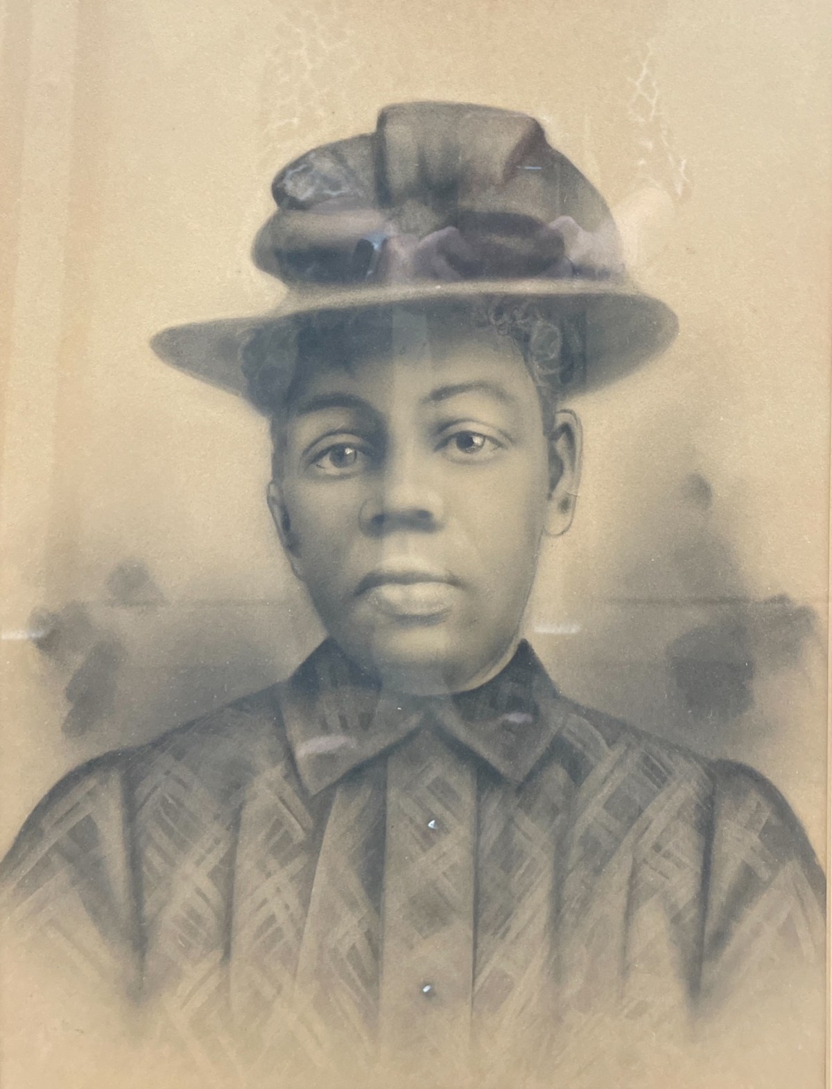
Crayon Enlargement Portraits were popular between the late 1890s and early 1900s. They provided an affordable way to capture and display large-format portraits, offering an alternative to the more expensive painted portraits of the time.
Crayon Enlargement Portraits were popular between the late 1890s and early 1900s. They provided an affordable way to capture and display large-format portraits, offering an alternative to the more expensive painted portraits of the time. The process involved taking a negative made by a local photographer and sending it to a specialist who used a solar enlarger to expose the image onto specially processed salted photographic paper. Because the enlargement process often emphasized imperfections on the negative plate, an artist would enhance the black-and-white print with pencil and crayon media, sometimes adding color.
The unidentified African American portraits featured on this website have been donated to local museums or found in antique shops. They are presented here in the hope of eventually identifying the individuals and preserving their stories.
Portrait of an unknown man (Courtesy of Montgomery Museum of Art and History)Portrait of an unknown man (Courtesy of Montgomery Museum of Art and History)Portrait of an unknown man, found in a New Town house, Blacksburg, Va (Courtesy of Montgomery Museum of Art and History)Portrait of an unknown woman (Courtesy of Montgomery Museum of Art and History)Portrait of an unknown man (Courtesy of Christiansburg Institute, Inc)Portrait of an unknown man (Courtesy of Christiansburg Institute, Inc)
This website serves as an important resource for understanding the history and legacy of slavery in our region. It contains information collected from Roanoke County sources about more than 4,000 enslaved individuals.
This website serves as an important resource for understanding the history and legacy of slavery in our region. It contains information collected from Roanoke County sources about more than 4,000 enslaved individuals. Many of the family names of enslaved African Americans recorded here also appear in neighboring Montgomery County, making this work deeply relevant to our local history. In addition, the family names of many individuals who enslaved others are found in the Roanoke primary sources.
The purpose of this page is to document and connect these shared names, with the hope of bringing to light the lives of those too often lost to history and deepening our understanding of the enduring legacy of slavery in Montgomery County and beyond.
More names will be added with time.
Family Names of Enslaved African Americans in Montgomery County
Brown
William Brown – enslaved by William Watts. “In IAS Book 4, the partition of the lands and other property of Edward Watts, William Brown is listed among the enslaved individuals that were bequeathed to Edward Watts’s daughter, Alice W. Morris. A value of $1,700.00 was placed on William Brown.”; Inventory, Appraisements, and Sales Book 4, Roanoke County Archives.
George Campbell – “George Campbell was listed in an indenture agreement: “…bind unto the said Lewis Zirkle a boy of colour named George Campbell until he arrives to the free age of twenty one which will be on the 25th day of June 1854.” In the Common Law book, it was ordered that the Overseers of the Poor bind out George, “a boy of color,” to Lewis Zinkle.”; Common Law Orders – A – May 1838 – May 1840, Roanoke County Archives.
Saunders/Sanders
Catherine Saunders – Mother of Henry Saunders; Common Law Orders – C – August 1843 – June 1848 – pgs. 227-478; Roanoke County Archives
Henry Saunders – 8 year old child of Catherine Saunders and Hercules Cuff, mention of Stephen Henry; Common Law Orders – C – August 1843 – June 1848 – pgs. 227-478; Roanoke County Archives
Magdeline Saunders – “Magdeline Saunders was listed in an indenture agreement: “unto the said Benjamin Hawley a girl of colour by the name of Magdeline Saunders until she arrives to the age of 21 years…the 22nd day of June 1858…” The Common Law book states that the Overseers of the Poor were ordered to bind out Magdalen Saunders, “a poor, colored girl” until she turned 21”; Common Law Orders – B – June 1840 – July 1843, Roanoke County Archives
Elizabeth Evans (List of first names of people they enslaved), “Elizabeth was listed in Michael Shepard’s property appraisement as having purchased enslaved people after Michael’s death. In the record, Elizabeth purchase” the enslaved people Joe, Nancy, and an unrecorded named child for $675.00.” She was possible daughter of Jonathan Evans. “Elizabeth’s son was William Evans and her husband was William W. Evans.”; Common Law Orders – B – June 1840 – July 1843, Roanoke County Archives