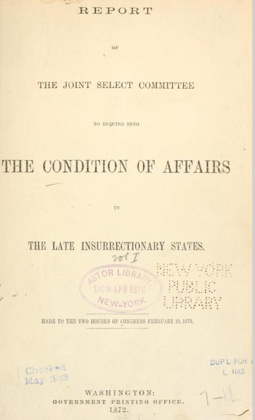
In 1872, a 13-volume compilation of reports and testimonies, including those from previously enslaved individuals, documented a Congressional committee’s investigation into the Ku Klux Klan and other insurrectionary movements in the former Confederate states.
In 1872, a 13-volume compilation of reports and testimonies, including those from previously enslaved individuals, documented a Congressional committee’s investigation into the Ku Klux Klan and other insurrectionary movements in the former Confederate states.
While Virginia is absent from this congressional report, the testimonies offer valuable insights into the beliefs, attitudes, misconceptions, and misdirections surrounding the mistreatment of newly freed people residing in the former Confederate states.
Montgomery County (Va.) Cohabitation Register. This register records the name of the husband, his age, place of birth, residence, occupation, last owner, last owner’s residence, name of the wife, her age, place of birth, residence, last owner, last owner’s residence, name of children with the ages of each, and the date of commencement of cohabitation. Of note is the wide range of localities reported as the former slaves’ places of birth
The University of Virginia Library’s Virginia Untold: The African American Narrative provides a comprehensive online archive of African American and related history. These primary sources are invaluable for researchers and genealogists. Search “Montgomery County, VA” to locate local materials, and include “Wythe County, VA,” as some Montgomery County records are held there. While the site offers search functionality, downloading PDF transcriptions allows for more targeted searching. Please note that name spellings may vary. Scroll down on this web page for additional online resources.
Montgomery County (Va.) Register of Colored Persons Cohabiting Together as Husband and Wife, 1866 Feb. 27. N.p., 1866.
This document is very valuable and now that it has been digitized it is accessible. Please read the description and historical note by the Library of Virginia: (accessed 3 March 2024)
Description Montgomery County (Va.) Register of Colored Persons of Montgomery County, State of Virginia, cohabiting together as Husband and Wife on 27th February 1866. Also commonly called Montgomery County (Va.) Cohabitation Register. This register records the name of the husband, his age, place of birth, residence, occupation, last owner, last owner’s residence, name of the wife, her age, place of birth, residence, last owner, last owner’s residence, name of children with the ages of each, and the date of commencement of cohabitation. Of note is the wide range of localities reported as the former slaves’ places of birth
Montgomery County (Va.) Register of Colored Persons Cohabiting Together as Husband and Wife, 1866 Feb. 27. N.p., 1866. Print.
Historical Note Note
Montgomery County was named for Richard Montgomery, who was killed in the American assault on Quebec late in 1775. It was formed from Fincastle County in 1776. Part of Botetourt County was added in 1789, and part of Pulaski County was added in 1842.
The Virginia legislature passed an act on 27 February 1866 to legalize the marriages of former slaves who had been cohabiting as of that date. See Virginia Acts of Assembly, 1866-1867, Chapter 18, An act to amend and re-enact the 14th section of chapter 108 of the Code of Virginia for 1860, in regard to registers of marriage; and to legalize the marriages of colored persons now cohabiting as husband and wife.
The federal Bureau of Refugees, Freedmen, and Abandoned Lands directed the Assistant Superintendents of the states to order the county clerks to make a registry of such cohabiting couples. See Circular No. 11, dated 19 March 1866, in Orders, Circulars, Circular Letters, and Letters of Instruction, vol. 2 (1866). Bureau of Refugees, Freedmen, and Abandoned Lands, Records of the Assistant Commissioner for the State of Virginia, 1865-1869. Miscellaneous reel 3880, Library of Virginia. National Archives microfilm M1048 (reel 41), Record Group 105.
Montgomery County (Va.) Register of Colored Persons Cohabiting Together as Husband and Wife, 1866 Feb. 27. N.p., 1866. Print.
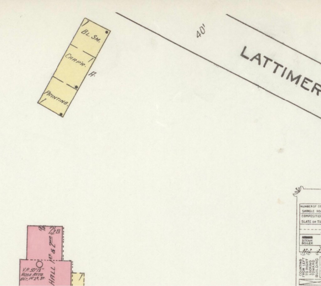
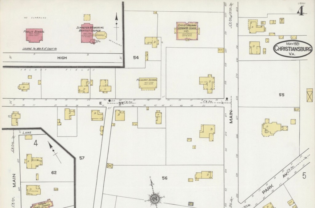
The Sanborn Fire Insurance maps are often the only early glimpse of buildings in rural towns over time. Christiansburg Industrial Institute moved from the Zion Hill location to the Lattimer Plantation site, north west of Christiansburg, at the turn of the 20th Century. This Sanborn Fire Insurance Map from Christiansburg, Montgomery County, Virginia was published by the Sanborn Map Company, dated Sep, 1913. The key to the maps is at the end.
The map is of Christiansburg Industrial Institute, situated north west of Cambria and north of Christiansburg courthouse. Note that frame constructed buildings are coded yellow and red for the solid brick building. The Baily Morris Building which housed the girls dorm, assembly hall, dinning hall and kitchen (close-up below) is heated by steam and lighted by electricity.
“Baily-Morris” Building
The Morris Hall Boys’ Dorm is both red and yellow, denoting built of a combination of building materials. The building is heated by hot water and lighted by electricity. Note that the buildings were supplied with water by 2,500 ft of pipes connected to the 10K gal water tank on the hill. The tank is filled by a Worthington Pump, moving water from a spring.
The girls and boys dorms were named for two Friends’ of the Freedmen of PA, Elliston P. Morris and Joshua L. Baily. They also donated money to construct the water system which was installed in 1907, before either Christiansburg or Blacksburg had a community water system. (A Vision of Education, Selected Writings of Edgar A. Long, Anna Fariello, Ed. Christiansburg Institute, Inc. 2021, pg 86,)
The Lattimer Mansion House, wood framed, was heated by stove and not connected to the water supply. The house was used as classrooms. Note the printing, carpenter and black smith shop close to the entrance road.
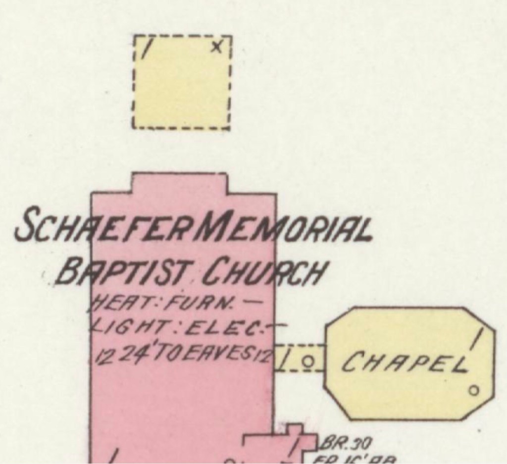
1913 Hill School & Schaeffer Memorial Baptist Church
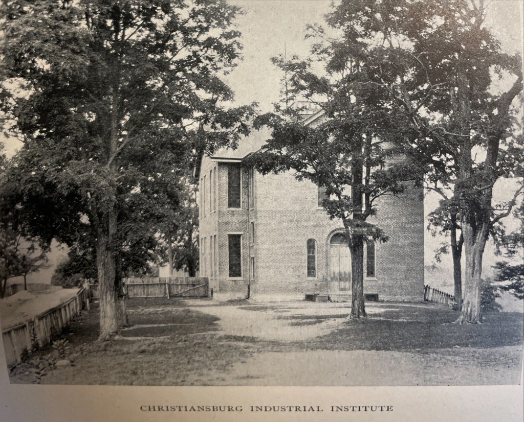
This map is of Zion Hill which is located on the ridge (now High Street) between Cambria and Christiansburg. The brick (red) “Public School” housed the Christiansburg Industrial Institute before that secondary school moved to the Lattimer Plantation property by the turn of 20th century. This brick school, built by 1885, was converted to a primary school for African American children after CII moved. As noted by the Sanborn map, the building was heated by stoves and lighted by electricity.
Image of the Hill School from The Story of a Consecrated Life, Commemorative of Rev. Charles S. Schaeffer by CH Harrison, 1900. High Street is visible.
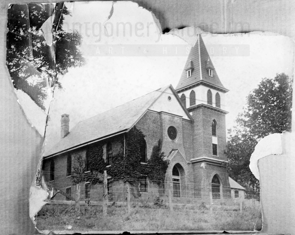
The Schaeffer Memorial Baptist Church is also of brick and built by 1885. Charles S Schaeffer’s memorial brass plaque were unveiled 1 October 1899, after he died in May of that same year. Note the frame chapel to the left (east) of the brick structure.
Image of Schaeffer Memorial Baptist Church from The Story of a Consecrated Life, Commemorative of Rev. Charles S. Schaeffer by CH Harrison, 1900. High Street is visible in the foreground. Later photograph, courtesy of the D.D. Lester Collection, Montgomery Museum of Art & History
On the Sanborn map, note the small frame, 1 story building behind the church? This may be the first school/church building on Zion Hill. The deed (DB S, pg 12, Oct 1868) and Harrison, 1900 * note the existence of this building. The brick school on the 1913 Sanborn map was the third version of this school at this site. The second school on Zion Hill was a 2 story & frame building, used between 1974 and 1885. (The rented Campbell house was the first school but it was not located on Zion Hill.)*
The image of the small school/meeting house shows a one story frame building with hip-roof and double stove-pipes. The dressed limestone block foundation was typical in this area and seen on buildings dating from early 1800s to the turn of the 20th century.
Image of the first school house on Zion Hill from The Story of a Consecrated Life, Commemorative of Rev. Charles S. Schaeffer by CH Harrison, 1900. High Street is visible in the foreground.
Captain Charles S. Schaeffer arrived in Christiansburg soon after the emancipation of enslaved people of Southwestern Virginia. In April 1866 he was appointed as an agent of the Bureau of Refugees, Freedmen, and Abandoned Lands (referred to as the Freedman’s Bureau). Schaeffer was US soldier who asked for to be assigned as an agent in Southwestern Virginia. He was assigned to Giles and Montgomery Counties, with headquarters in Christiansburg, VA.
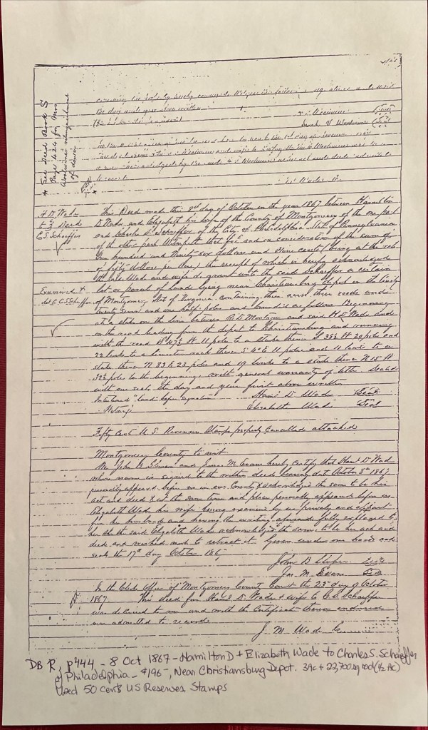
October 8, 1867, Hamilton D. and Elizabeth Wade sold Schaefer about 3.5 acres for $196 on a road leading from the Depot (Cambria*) to the town of Christiansburg (deed book R, pg 444). It is upon this land that Schaefer built a home of stone on the western portion and called it Zion Hill.
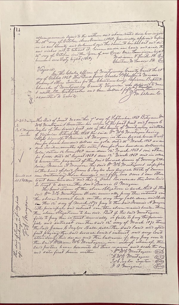
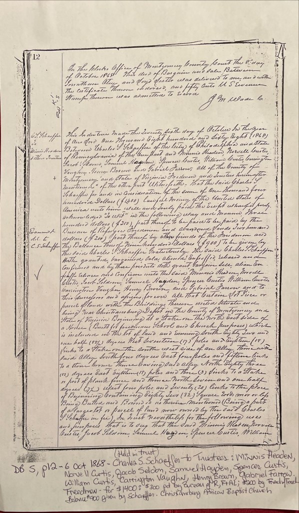
About one year later, October 6, 1868, Schaeffer deeded about a half an acre to the Trustees to be used as a school and the Christiansburg African Baptist Church (deed book S, pg 12). The Trustees: Minnis Headen, Norvell Curtis, Jacob Seldon, Samuel Hayden, Spencer Curtis, William Curtis, Carrington Vaughn, Henry Brown, and Gabriel Farrow. The cost of the land was $1,400. The Freedmen’s Bureau paid $300, the Friends’ of the Freedmen paid $200, & Schaeffer gifted the balance of $900. As noted in the deed a house was on the land, in use as a school and meeting house by the time of this deed. We believe this is the first school at this location. Schaeffer and the Trustees built two other structures with time.
Deed Book R, pg 444. Hamilton D. & Elizabeth Wade to Charles S. SchaefferDeed Book S, pg 12. Schaeffer, Bureau Freedmen & Friends’ of Freedmen to Trustees of the Christiansburg African Baptist ChurchZion Hill – 1921 Sanborn Fire Map of Christiansburg with the School and Baptist Church in red (brick) at the top, left.
*The Depot was Bangs which then was named Cambria in the late 1890s.
Photograph courtesy of the D.D. Lester Collection, Montgomery Museum of Art & History
Linda Killen transcribed the reports of Brevet-Captain Charles S. Schaeffer who held the post of agent for the Bureau of Refugee, Freedmen and Abandoned Lands during the early years of Reconstruction. More information about Schaeffer can be found at Christiansburg Institute, Inc.. Schaeffer sent this list of African American Freedmen to his reporting officer, Bvt. Brig. Genl. O. Brown, dated 15 March 1867 (page 18). Minnis Headen (Hadean) was listed on the deeds as Trustee for the Hill School and Christiansburg African Baptist Church.
“C. Minnis Hadean – Age 40 – Blacksmith – Christiansburg Va. – can read, write and cipher – one of the best colored men in the state.”
John Campbell – Age 40 – Farmer – Big Springs Depot Mont’y Co. Va – can read and write – owns property – was free before the war.
Peter Noulen (?) – Assistant to a Machinist – Depot of the Va. & Tenn. R.R. – Central Depot, [Radford], Mont’y Co. Va. – can read a little.
Sampson Gleaves – Age 35 – Farmhand – Christiansburg P.O. Lives one mile from town – Can read (and write a little).
Robert D. Jones – Age 30 – Farmer – Christiansburg P.O. Lives six miles from town – Can read and write.
Felix Johnson – Age 30 – Brick Layer – Christiansburg P.O. Lives in the direction of Blacksburg Va. – Can read and write.
John P. Taylor – Age 35 – Farmhand – Christiansburg P.O. Lives in the direction of the White Sulphur Springs – Can read & write.
Richard Taylor – Age 65 – Farmer & Preacher – Christiansburg P.O. – Lives near Blacksburg Mont’y Co. Va. – Cannot read nor write, but is quite intelligent.