The exact location of this church in the Childress area remains unknown. A 1940 school map shows nearby schools but lists only Pine Woods, a Rosenwald-funded African American school. Because schools were often built near churches, the map—and the noted Shelburne home—may offer clues to where the congregation once gathered.
Rough & Ready Church in Childress, Va – Roanoke Times, 05 August 1923, page 20
The exact location of this church in the Childress area is unknown. A 1940 school map identifies local schools but does not mark any African American schools, except Pine Woods School, which was built with Rosenwald funds. In many communities, schools were often situated near churches, so their locations can offer valuable clues. A Shelburne home also appears on this map, suggesting possible connections within the neighborhood.
The Roanoke Times, 05 August 1923, page 20
During a violent electrical storm Monday, lightning struck a son of Authur Shelburne near the colored church “Rough & Ready.”
This searchable document is a rich source of information about the county and its wider connections. For example, it notes that the New River boatmen once lived on Kent Farm, where they were enslaved by James Randle and Margaret Cloyd Kent prior to emancipation (see page 13). Additional details about Kentland and these freedmen can be found in the following postings: Historic Kentland and Historic Wake Forest
The names of some of the black boatmen of 19th-century Montgomery County include Frank Bannister (who was a boatman on the James River before the Civil War), Calvin Bannister, Roland Stuart, George Brown, and Lewis Smith.
This report that was written by Gibson Worsham, Dan Pezzoni, Charlotte Worsham, David Roenizer, and others. It addresses the following: 1) Overview of the county’s history, 2) A comprehensive inventory of significant structures and sites in the county and 3) Maps delineating the location of said structures and sites. Similar to the report above, this is a wealth of information about the county.
The Formation of Montgomery County, Virginia and Why it Matters to African American History of the Region
When Virginia’s earliest European colonial settlers first pushed westward beyond the Blue Ridge Mountains, they entered the border lands already inhabited by Native peoples for thousands of years. As Europeans laid claim to these territories in the 18th century, Virginia’s county boundaries began shifting rapidly to keep pace and the need for local governance.
At first, all of western Virginia was considered part of vast counties based far to the east. Augusta County, created in 1738, stretched from the Blue Ridge to the Mississippi River—a landmass so large it was nearly impossible to govern effectively. As settlement expanded, Augusta was gradually carved into smaller counties.
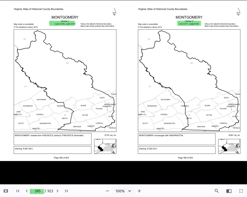
Botetourt County was created in 1770 out of Augusta, and just two years later, in 1772, Fincastle County was formed to cover the far southwest. But Fincastle itself was short-lived: in 1776, it was split into three new counties—Montgomery, Washington, and Kentucky (the latter eventually becoming the Commonwealth of Kentucky).
Thus, Montgomery County was officially established in 1776, named in honor of General Richard Montgomery, a Revolutionary War hero.
Like most early counties, Montgomery did not remain the same size for long. As population grew and communities demanded closer courts and local representation, Montgomery’s original boundaries were gradually reduced.
1790: Wythe County was formed from Montgomery.
1790: Parts of Montgomery contributed to the creation of Kanawha County (now in West Virginia).
1806: Giles County was carved from Montgomery, Monroe, Wythe, and Tazewell.
1831: Montgomery giving land to Floyd
1839: Montgomery giving land to Pulaski
1892: City of Radford
By the mid-19th century, Montgomery County had taken on the approximate shape we recognize today.
Why This Matters
Tracing these changing boundaries shows how the western border lands of Virginia evolved from a vast Indigenous landscape into the network of counties we know today. When we study Montgomery County’s formation and its changing borders, we are not only tracking political geography—we’re also uncovering how those shifts shaped the daily realities of enslaved people and freedmen. The “line on a map” often meant the difference between where families were recorded, where they could live, and how they could begin to claim freedom and opportunity.
County seats like Christiansburg were not only centers of trade and government but also of the slave market and the courthouse records that tracked the lives of enslaved people. After emancipation, those same courts became the places where freedmen registered marriages, secured contracts, and sought land. As county lines shifted, so too did the jurisdictions that controlled access to justice, opportunity, and community life.
The flip book of maps below is a helpful resource to understand how the boundaries changed with time. Begin on page 395.
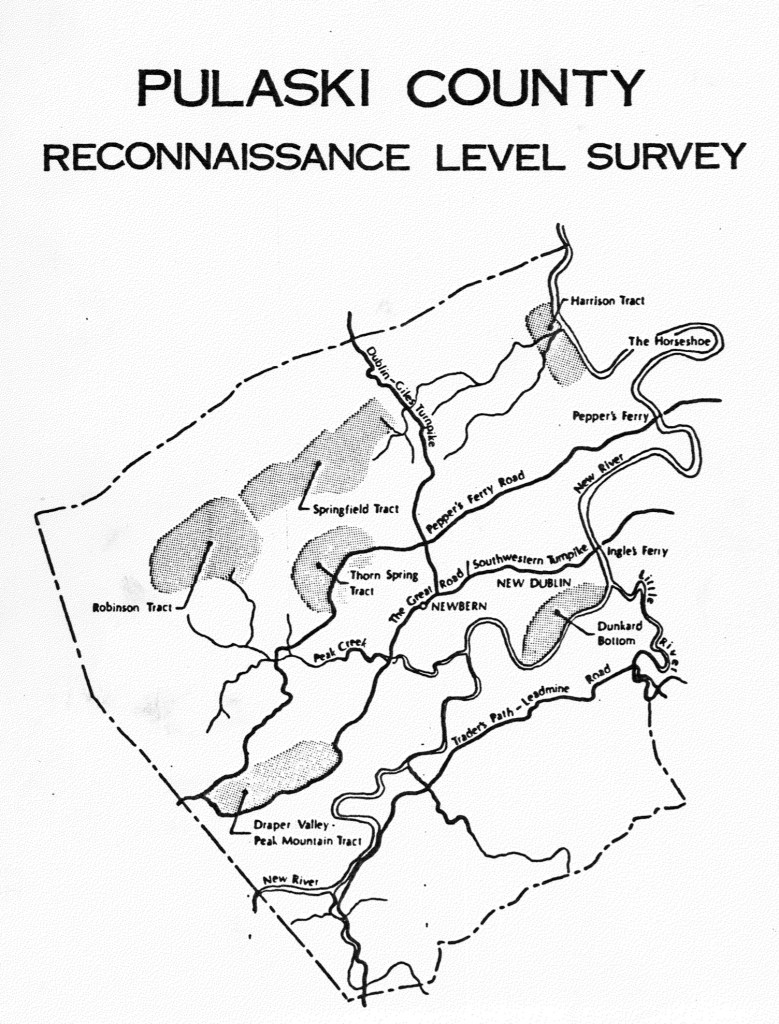
Pulaski County Reconnaissance Survey, created by Gibson Worsham, Dan Pezzoni, and many others, is such a valuable resource. It provides vital insights into African American history in Southwest Virginia and the greater Central Appalachian region, helping us better understand the interconnected stories that shaped our communities.
Montgomery County, Virginia, has never existed in isolation.
The people who have lived here—whether by choice, through enslavement or servitude, or as Indigenous communities who established towns long before European arrival—moved across boundaries freely. They traveled, traded, fought, buried their dead, and carried out the everyday work of survival across what later became county lines.
This is why the Pulaski County Reconnaissance Survey, created by Gibson Worsham, Dan Pezzoni, and many others, is such a valuable resource. It provides vital insights into African American history in Southwest Virginia and the greater Central Appalachian region, helping us better understand the interconnected stories that shaped our communities.
This report is fully searchable and contains valuable early documentation on African American schools, churches, and communities. It also includes a generalized map that highlights both early European settlements and land tracts. For example, Dunkard’s Bottom—now submerged beneath Claytor Lake—was once part of an early German settlement.
The report also identifies significant Scotch-Irish tracts such as Draper Valley/Peak Mountain, Harrison, Robinson, Springfield, and Thorn Spring. It notes the communities of Newbern and New Dublin, along with the region’s main transportation routes: Traders Path/Leadmine Road, the Great Road/Wilderness Road/Southwestern Turnpike, Peppers Ferry Road, and the Dublin/Giles Turnpike.
The report offers a clear explanation of the early Importation and Treasury Rights system used to claim land (see pages 23–24). For further detail, see F.B. Kegley, Kegley’s Virginia Frontier, Roanoke, VA: Southwest Virginia Historical Society, 1938. p. 59.
The report contains interesting data about the enslaved, noted on page 44. Also, the churches and New River Village is discussed beginning on page 56.
In Pulaski the pattern of large landholding influenced the ownership of slaves. Whereas in Montgomery County there were 2,219 slaves, and in Pulaski only 1,589 in 1859, eight slaveholders had more than fifty slaves in Pulaski while only two landowners in Montgomery possessed as many. In both counties, however, the majority of owners possessed ten or fewer slaves. During the Civil War, the Confederacy began requisitioning slaves to work in the war effort. At the beginning of the war many slaves were requisitioned and shipped to Richmond to fortify the state capital. In the following three years slaves were requisitioned four times so that by 1865 the county found it could no longer comply as it was being drained of free and slave manpower, food supplies and money.
Timeline was created for the 2030 Comprehensive Plan of Pulaski County
A Note on the Language in the County’s Comprehensive Plan
As part of Montgomery County’s 30-year Comprehensive Plan, a historical timeline was created. While the dates provided are generally accurate, the language used to describe Indigenous people and borderlands does not align with our values.
We want our readers to be aware that these depictions reflect the language of the plan’s authors—not the values or beliefs of this website. Our commitment is to present history in a way that acknowledges the dignity, presence, and contributions of all people who have lived in this region.
Note that the African American community of “New River” came to exist after emancipation.
The First Negro Churches in the District of Columbia, John W. Cromwell, 64-106 p., Lancaster, Pa.; Washington, D. C. The Association for the Study of Negro Life and History, Inc., 1917 From the Journal of Negro History 7, no.1 (January 1922), 64-106. Call number E185 .J86 v. 7 1922 (Davis Library, University of North Carolina at Chapel Hill)
Many names associated with Montgomery County, Virginia: Anderson, Bell, Green, Hunter, Johnson, Muse, Saunders, Stewart, Taylor, Walker
Odd Fellows as well as the history of the establishment of churches in the District of Columbia.
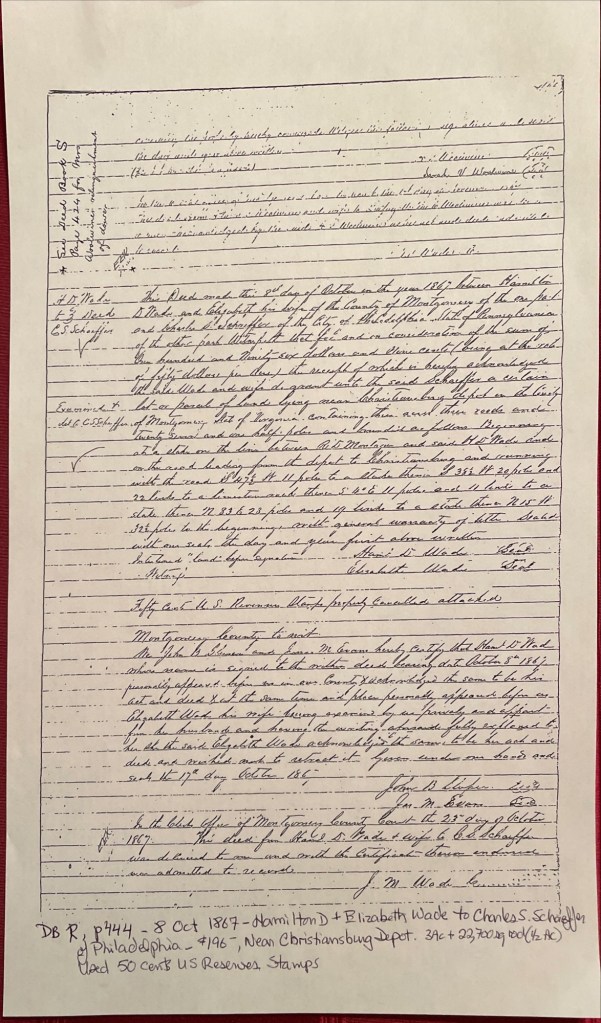
Captain Charles S. Schaeffer arrived in Christiansburg soon after the emancipation of enslaved people of Southwestern Virginia. In April 1866 he was appointed as an agent of the Bureau of Refugees, Freedmen, and Abandoned Lands (referred to as the Freedman’s Bureau). Schaeffer was US soldier who asked for to be assigned as an agent in Southwestern Virginia. He was assigned to Giles and Montgomery Counties, with headquarters in Christiansburg, VA.
October 8, 1867, Hamilton D. and Elizabeth Wade sold Schaefer about 3.5 acres for $196 on a road leading from the Depot (Cambria*) to the town of Christiansburg (deed book R, pg 444). It is upon this land that Schaefer built a home of stone on the western portion and called it Zion Hill.
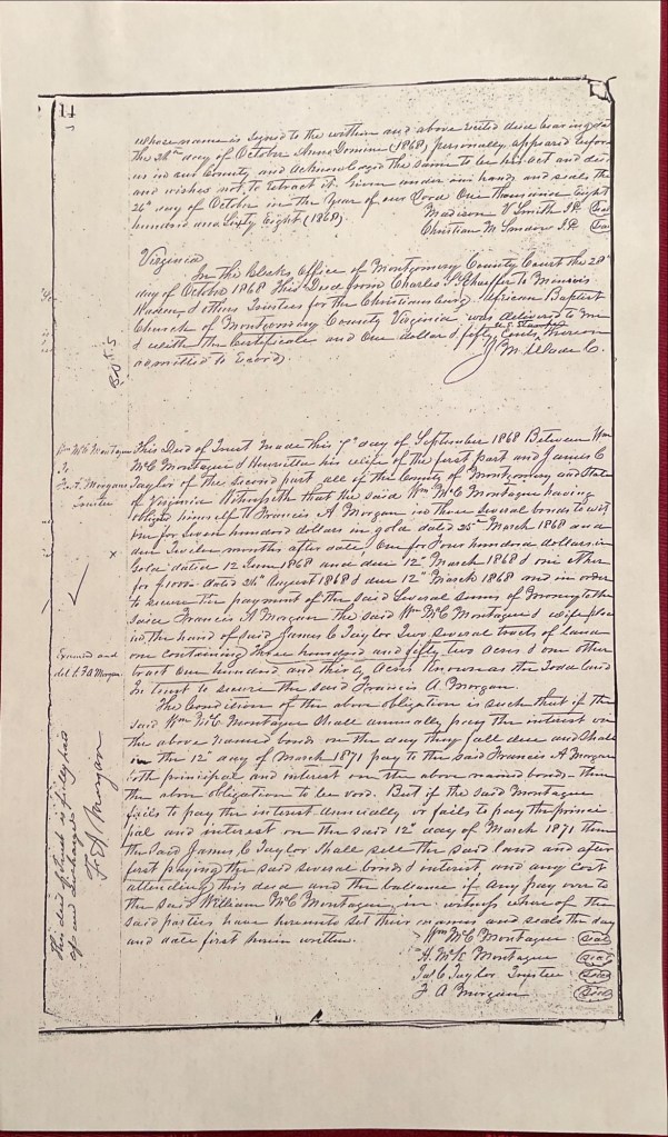
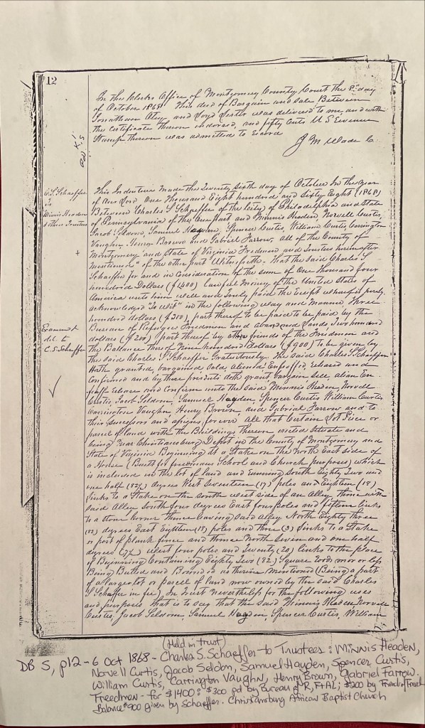
About one year later, October 6, 1868, Schaeffer deeded about a half an acre to the Trustees to be used as a school and the Christiansburg African Baptist Church (deed book S, pg 12). The Trustees: Minnis Headen, Norvell Curtis, Jacob Seldon, Samuel Hayden, Spencer Curtis, William Curtis, Carrington Vaughn, Henry Brown, and Gabriel Farrow. The cost of the land was $1,400. The Freedmen’s Bureau paid $300, the Friends’ of the Freedmen paid $200, & Schaeffer gifted the balance of $900. As noted in the deed a house was on the land, in use as a school and meeting house by the time of this deed. We believe this is the first school at this location. Schaeffer and the Trustees built two other structures with time.
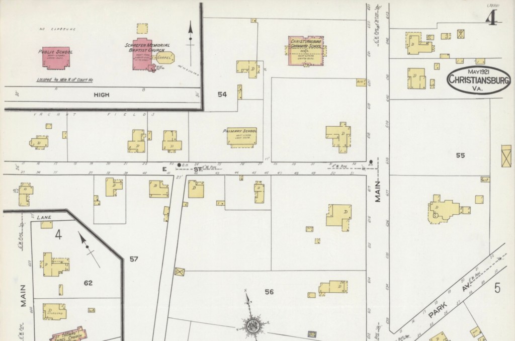
Deed Book R, pg 444. Hamilton D. & Elizabeth Wade to Charles S. SchaefferDeed Book S, pg 12. Schaeffer, Bureau Freedmen & Friends’ of Freedmen to Trustees of the Christiansburg African Baptist ChurchZion Hill – 1921 Sanborn Fire Map of Christiansburg with the School and Baptist Church in red (brick) at the top, left.
*The Depot was Bangs which then was named Cambria in the late 1890s.
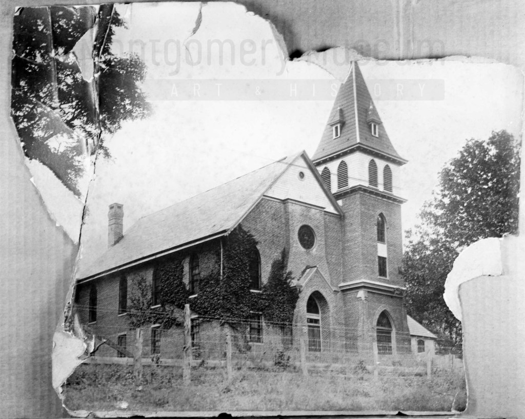
Photograph courtesy of the D.D. Lester Collection, Montgomery Museum of Art & History