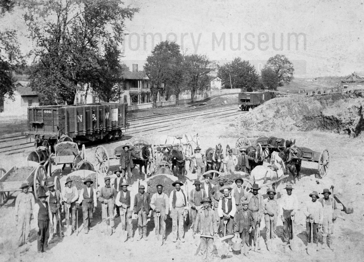
In 1904, a mixed-race crew built the new Cambria, Virginia Depot passenger station. Their faces were captured, but their names were not. As we search census records and explore new tools like AI facial recognition, we hope to uncover who they were — the hands and lives behind this piece of our shared history.
Facebook PostCambria Depot Work Crew, about 1904 (DD Lester Collection, Montgomery Museum of Art & History)Close-up of Cambria Depot Work Crew, about 1904 (DD Lester Collection, Montgomery Museum of Art & History)Close-up of Cambria Depot Work Crew, about 1904 (DD Lester Collection, Montgomery Museum of Art & History)Close-up of Cambria Depot Work Crew, about 1904 (DD Lester Collection, Montgomery Museum of Art & History)
This 1904 photograph captures a work crew—Black and white men together—building the new passenger station for the Cambria, Virginia Depot. It’s a remarkable image of shared labor and community effort during a time of deep segregation.
Yet, like so many images from the early 20th century, the men remain unnamed, except for the foreman, Willie Corell. Their faces look back at us across more than a century, but their identities have been lost to time. Who were they? What were their lives like?
With advancing technology, tools like AI facial recognition may one day help uncover their names and family connections. Until then, our research turns to the 1900 and 1910 census records, where we hope to find traces of the African American laborers who helped shape the Cambria community and build this station that still stands as part of our shared history.
If you have family stories, photographs, or names that might help identify these men, we would love to hear from you. Each clue brings us closer to giving them the recognition they deserve.
Fisk University has released its Rosenwald School Digital Collection, preserving and sharing the history of these vital institutions. In Montgomery County, the collection highlights schools built through the determination of African American communities in Elliston, Pine Woods, Shawsville, and Wake Forest.
Fisk University has made its Rosenwald School Digital Collection publicly accessible, a significant step in preserving and sharing the history of these important institutions. For Montgomery County, the collection documents the Rosenwald Schools established through the determination and vision of African American communities in Elliston, Pine (Piney) Woods near Riner, Shawsville, and Wake Forest.
Although only the Wake Forest school remains today—adapted for use as a private residence—the collection ensures that the legacy of all three schools endures. These schools stand as a testament to community leadership, resilience, and the transformative power of education during the early twentieth century.
The Story of Rosenwald Schools
The website (scroll down) offers a wealth of information: the story of Julius Rosenwald and his vision, the purpose of the school fund, the significance of the school designs, and the requirement that African American communities contribute a share of the cost. Visitors will also find maps, photographs, and documentation of schools across the region and beyond.
Elliston School Info1940 School Census Map2002 Image (Courtesy of Meadowbrook Museum, Shawsville)Image of the list of students in 1935 (Courtesy of Meadowbrook Museum, Shawsville, James Earnest Dow document)
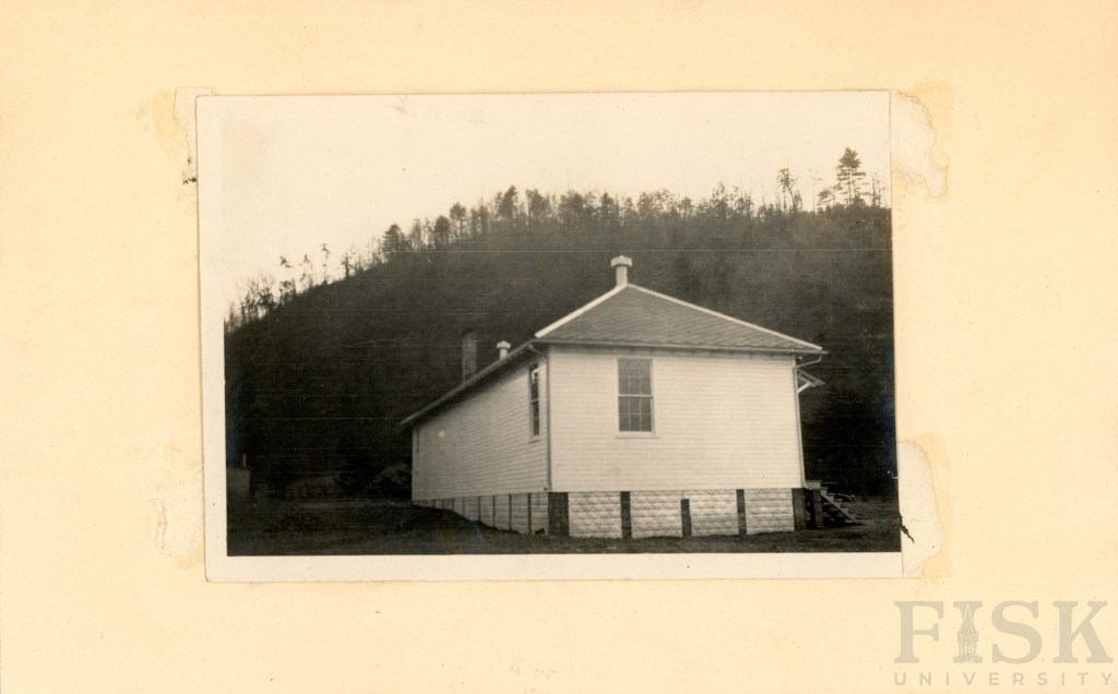
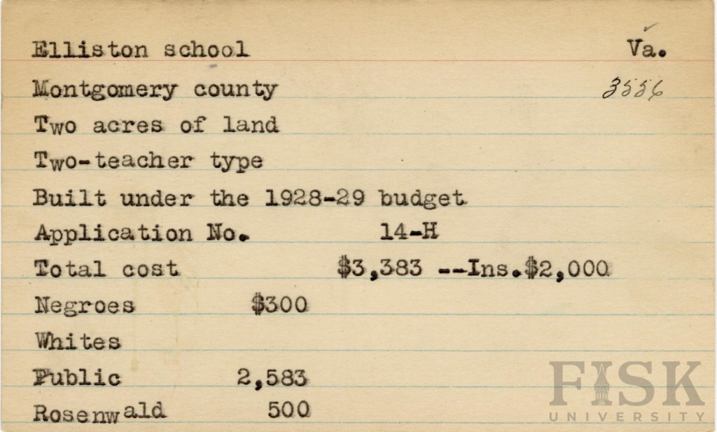
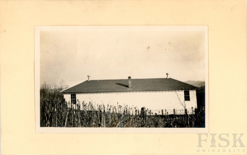
Built in 1928–1929, the Elliston Rosenwald School reflects the determination of the local African American community to provide better educational opportunities for their children. Families in Elliston raised $300 toward the project, which was matched by $500 from the Rosenwald Fund and $2,583 from the Montgomery County School Board.
The school stood on two acres of land and housed two classrooms, each with its own teacher. The school was located on Brake Road, in the Allegheny School District. The legacy: the Elliston Rosenwald School was a center of learning, community, and pride during an era when access to education was hard-won.
The Pine Woods Rosenwald School (Piney Woods) was built in a two-teacher design under the supervision of Tuskegee University. The school was sited on Piney Woods Road, in the Auburn School District. While the exact construction date is unknown, records indicate the total cost was $1,075. Of that amount, the Rosenwald Fund contributed $300, the African American community raised $275, and the Montgomery County School Board provided $500.
Unlike white schools of the period, which were fully funded by the School Board, African American families were required to make direct financial contributions toward the construction of their schools. This inequity underscores both the systemic barriers they faced and the extraordinary commitment of the Pine Woods community to ensuring education for their children.
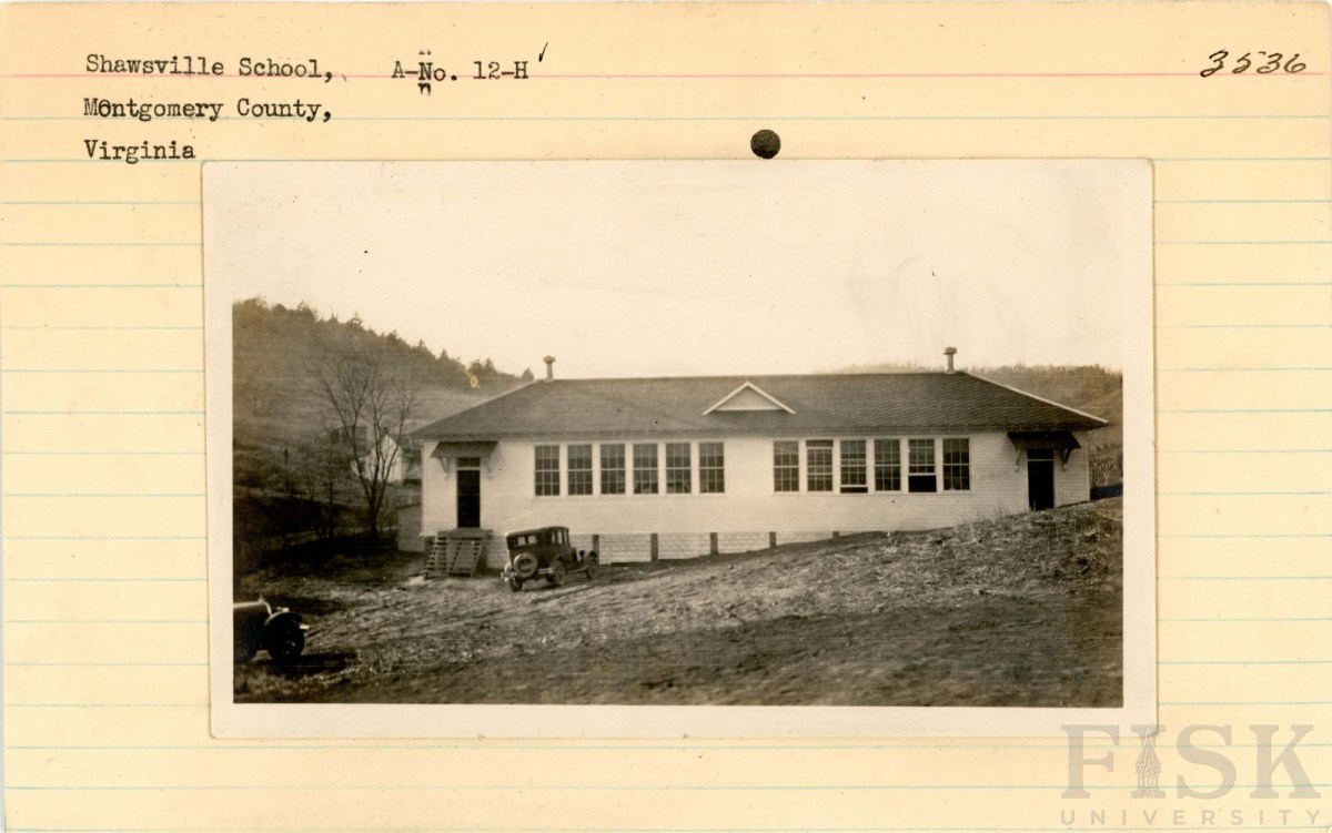
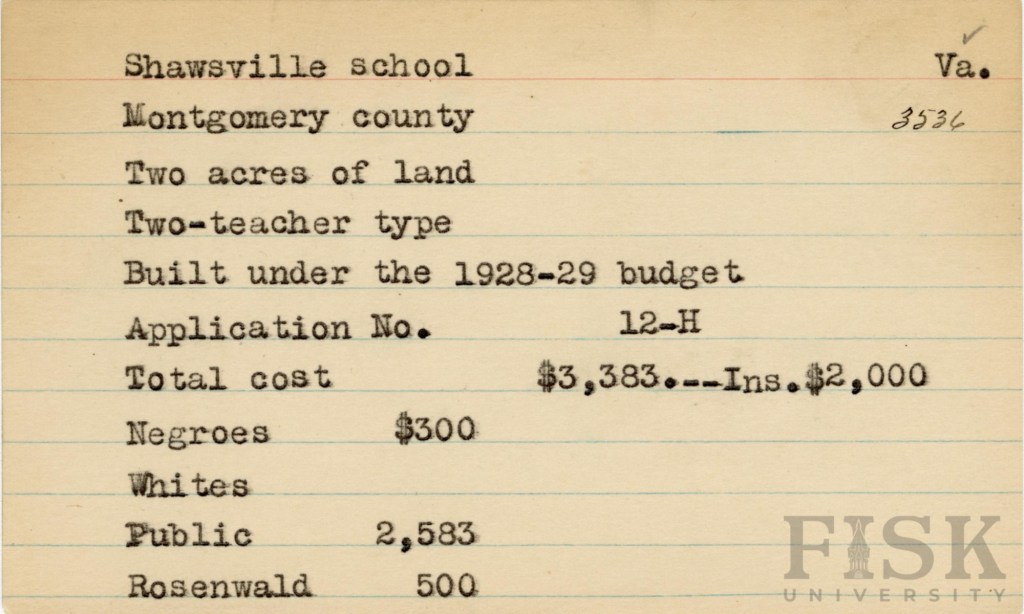
Constructed between 1928 and 1929, the Shawsville Rosenwald School followed a two-teacher design overseen by the Montgomery County School Board. The total cost of $3,383 was shared among the Rosenwald Fund ($500), the African American community ($300), and the Montgomery County School Board ($2,583).
At the time, Shawsville, of the Allegheny School District, was a thriving hub, energized by railroad service and new road (US Route 11) construction projects. These opportunities drew African American laborers and rail workers to the area, many of whom invested their limited resources into building a school for their children. Their contributions—financial and communal—stand as a testament to the determination of Shawsville’s African American families to secure education despite inequities in public funding.
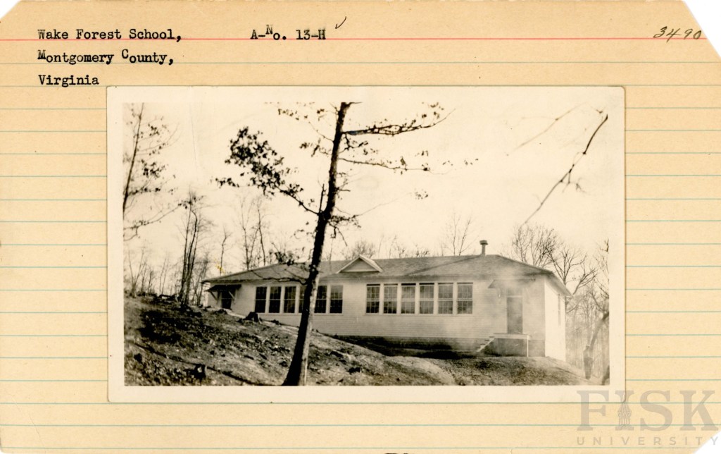
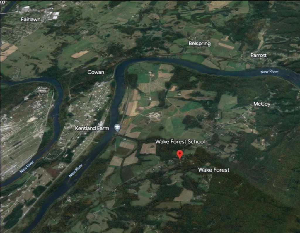
Constructed between 1928 and 1929, the Wake Forest Rosenwald School followed a two-teacher design on a two-acre site, in the Blacksburg School District, overseen by the Montgomery County School Board. The project cost $3,383, with funding shared by the Rosenwald Fund ($500), the African American community ($426 in 1928, about $7,500 in today’s value), and the Montgomery County School Board ($2,457). This school is now a private residence.
The Wake Forest community at this time was made up of independent farmers, farm laborers, boatmen, railroad workers, teamsters, and domestic workers. As coal extraction began to rise and reshape the region’s economy, African American families recognized that education would be essential for their children’s future. By pooling their resources—despite economic hardship—they ensured access to schooling that could open paths beyond the limits of labor and provide new opportunities for the next generation.
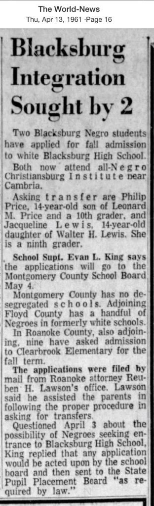
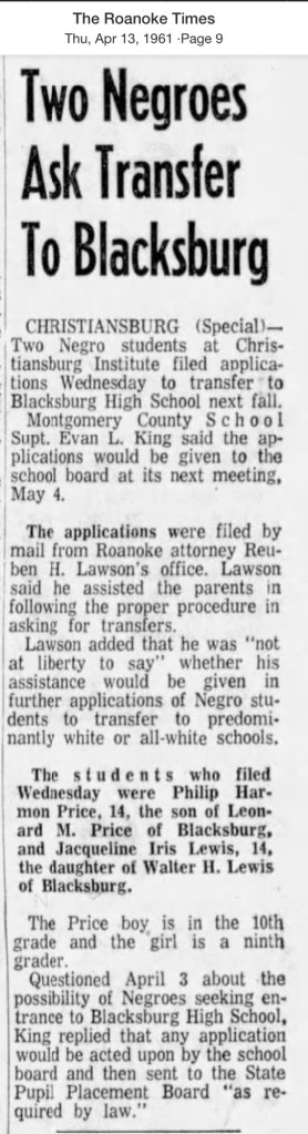
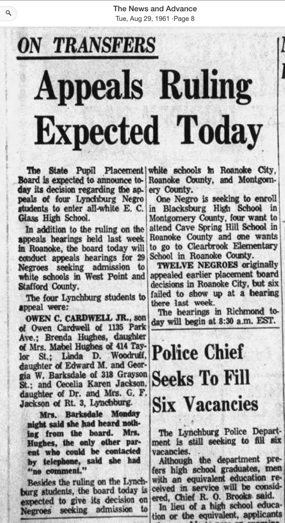
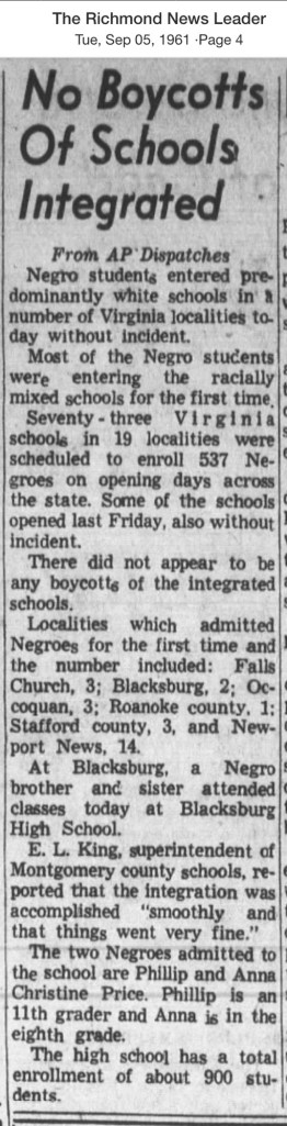
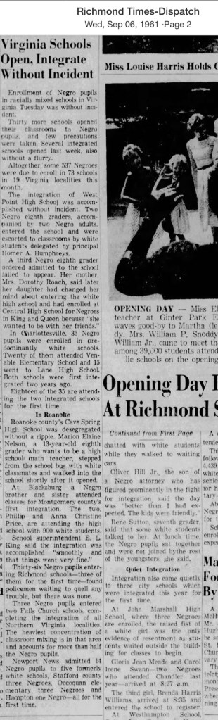
In 1961, Blacksburg High School became the first in Montgomery County to admit African American students, paving the way for full integration of all county high schools by 1966.
After the U.S. Supreme Court’s 1954 Brown v. Board of Education ruling outlawed segregation, Montgomery County resisted. The school board leaned on “states’ rights” arguments and used tactics from Virginia’s Gray Commission—such as controlling student assignments and offering tuition grants to white families—to delay integration for years.
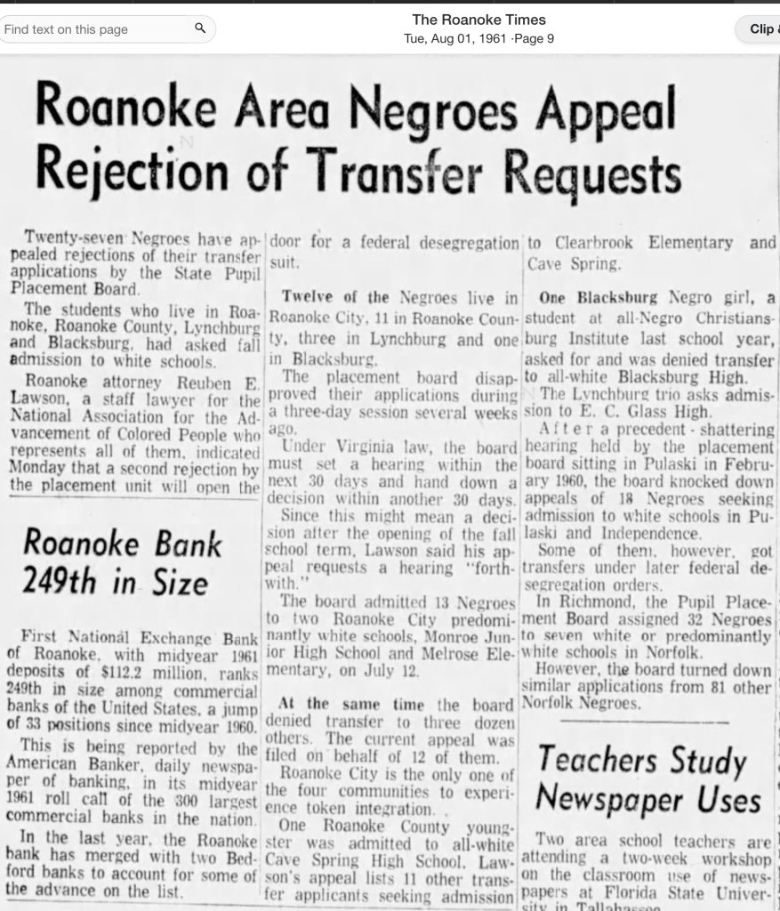
Amidst this resistance, three students from Christiansburg Institute applied to transfer to the all-white Blacksburg High School, which then enrolled about 900 students. They were siblings Phillip H. Price (15) and Ann Christine Price (13), along with Jacqueline Iris Lewis (14). With support from NAACP attorney Reuben E. Lawson of Roanoke, their applications went before the State Pupil Placement Board. Phillip and Ann Christine were admitted for the 1961 school year, but Jacqueline’s request was denied on the grounds of “academic standards”—a requirement never applied to white students.
On August 23, 1961, Jacqueline and her father, Walter H. Lewis, traveled to Roanoke for the hearing, an intimidating experience for a 14-year-old. The Board delayed its ruling for a week before denying her appeal. That fall, Jacqueline remained at Christiansburg Institute.
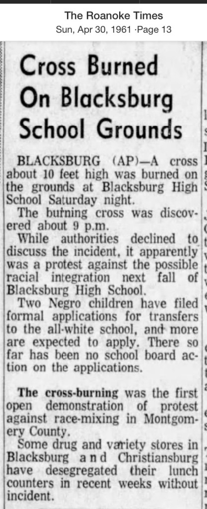
That September, Phillip and Ann Christine Price became the first Black students to integrate Montgomery County schools when they walked into Blacksburg High. According to researcher Tracy A. Martin, they were not alone—their white neighbors walked beside them in solidarity. This act of courage followed a chilling warning: on April 29, 1961, a ten-foot burning cross had been discovered on the school grounds, South Main Street.
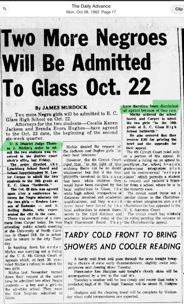
In 1962, the school board again delayed the application process for two more students seeking admission. Yearbooks from 1961–1964 suggest that the Price siblings were the only African American students at Blacksburg High during those early years. In the years that followed, more students of color began to appear in the yearbooks. By 1966, the school board closed Christiansburg Institute, and all of the county’s white high schools were finally opened to every student.
Phillip H. PriceAnn Christine Price
Newspaper Articles
April 1961
04 April 1961 Daily Progress04 April 1961 The Free Lance-Star04 April 1961, Roanoke Times04 April 1961 Martinsville Bulletin13 April, 1961 The World-News13 April 1961, Roanoke Times13 April 1961 News & Advance14 April 1961 The World News17 April 1961 The World-News19 April 1961, Ledger-Star30 April 1961 “Cross Burned on Blacksburg School Grounds” Roanoke Times
July 1961
26 July 1961 Richmond News Leader26 July 1961 Danville Register & Bee31 July 1961 The World-News
August 1961
01 August 1961 Roanoke Times10 August 1961 Roanoke Times21 August 1961 The World News23 August 1961, Danville Register & Bee23 August 1961 The World News29 August 1961 The News and Advance
September 1961
05 September The Richmond News Leader05 September 1961 The Ledger-Star06 September 1961 The Richmond Times Dispatch 06 September 1961 The Virginia Pilot06 September 1961 The News and Advance05 September The Ledger-Star
1962 Application of Two Young Women, the Courts Ruling
18 May 1962 Roanoke Times14 July News and Advance08 October 1962 Daily Advance
The Formation of Montgomery County, Virginia and Why it Matters to Regional African American History
When Virginia’s earliest European colonial settlers first pushed westward beyond the Blue Ridge Mountains, they entered the border lands already inhabited by Indigenous peoples for thousands of years. As Europeans laid claim to these territories in the 18th century, Virginia’s county boundaries began shifting rapidly to keep pace and the need for local governance.
At first, all of western Virginia was considered part of vast counties based far to the east. Augusta County, created in 1738, stretched from the Blue Ridge to the Mississippi River—a landmass so large it was nearly impossible to govern effectively. As settlement expanded, Augusta was gradually carved into smaller counties.
Botetourt County was created in 1770 out of Augusta, and just two years later, in 1772, Fincastle County was formed to cover the far southwest. But Fincastle itself was short-lived: in 1776, it was split into three new counties—Montgomery, Washington, and Kentucky (the latter eventually becoming the Commonwealth of Kentucky).
Thus, Montgomery County was officially established in 1776, named in honor of General Richard Montgomery, a Revolutionary War hero.
Like most early counties, Montgomery did not remain the same size for long. As population grew and communities demanded closer courts and local representation, Montgomery’s original boundaries were gradually reduced.
1790: Wythe County was formed from Montgomery. 1790: Parts of Montgomery contributed to the creation of Kanawha County (now in West Virginia). 1806: Giles County was carved from Montgomery, Monroe, Wythe, and Tazewell. 1806–1830s: Additional shifts continued, with Montgomery giving land to Floyd (1831), Pulaski (1839), and others.
By the mid-19th century, Montgomery County had taken on the approximate shape we recognize today.
Why this matters
Tracing these changing boundaries shows how the western border lands of Virginia evolved from a vast Indigenous landscape into the network of counties we know today. When we study Montgomery County’s formation and its changing borders, we are not only tracking political geography—we’re also uncovering how those shifts shaped the daily realities of enslaved people and freedmen. The “line on a map” often meant the difference between where families were recorded, where they could live, and how they could begin to claim freedom and opportunity.
County seats like Christiansburg were not only centers of trade and government but also the location of the slave market and the courthouse records that tracked the lives of enslaved people. After emancipation, those same courts became the places where freedmen registered marriages, secured contracts, and sought land. As county lines shifted, so too did the jurisdictions that controlled access to justice, opportunity, and community life.
Further Discussion on How Shifting Boundaries Change Lives
Laws & Records
When county boundaries changed, so did the courthouse where records were kept. For enslaved people, this meant that bills of sale, wills, deeds, and manumission papers might end up filed under different counties as the boundaries shifted. After emancipation, the same was true for marriage licenses, labor contracts, and land purchases by freedmen. This scattering of records makes it both complicated when tracing family histories.
Shaping Community, Labor & Education
County lines determined where enslaved people were forced to labor, where patrols were organized, and where courts enforced slavery laws. After emancipation, those same boundaries shaped freedmen’s access to work, land, and schools. For example, as new counties like Giles or Pulaski were created from Montgomery, Freeman might find themselves suddenly in a different jurisdiction, dealing with a new local power structure.
Education also reflected these divisions. Freedmen near Christiansburg had better access to schools supported by the Freedmen’s Bureau, while those in rural reaches of the county received little help.
Courts and Law
During slavery, county seats (like Christiansburg) were centers of trade, law, and the slave market. Enslaved people were taken to county courts for sales, trials, and punishment. After emancipation, those same county seats became the centers where freedmen registered marriages, secured legal recognition, and later sought protection under Reconstruction policies.
Land, Freedom, and Mobility
For freedmen, land ownership was key to independence. But access to land varied widely from one county to another, depending on who owned large estates, which lands were subdivided, and how local officials treated Black landholders. County boundaries thus shaped the possibilities of building self-sustaining communities after emancipation.
This searchable document is a rich source of information about the county and its wider connections. For example, it notes that the New River boatmen once lived on Kent Farm, where they were enslaved by James Randle and Margaret Cloyd Kent prior to emancipation (see page 13). Additional details about Kentland and these freedmen can be found in the following postings: Historic Kentland and Historic Wake Forest
The names of some of the black boatmen of 19th-century Montgomery County include Frank Bannister (who was a boatman on the James River before the Civil War), Calvin Bannister, Roland Stuart, George Brown, and Lewis Smith.
This report that was written by Gibson Worsham, Dan Pezzoni, Charlotte Worsham, David Roenizer, and others. It addresses the following: 1) Overview of the county’s history, 2) A comprehensive inventory of significant structures and sites in the county and 3) Maps delineating the location of said structures and sites. Similar to the report above, this is a wealth of information about the county.
The Formation of Montgomery County, Virginia and Why it Matters to African American History of the Region
When Virginia’s earliest European colonial settlers first pushed westward beyond the Blue Ridge Mountains, they entered the border lands already inhabited by Native peoples for thousands of years. As Europeans laid claim to these territories in the 18th century, Virginia’s county boundaries began shifting rapidly to keep pace and the need for local governance.
At first, all of western Virginia was considered part of vast counties based far to the east. Augusta County, created in 1738, stretched from the Blue Ridge to the Mississippi River—a landmass so large it was nearly impossible to govern effectively. As settlement expanded, Augusta was gradually carved into smaller counties.
Botetourt County was created in 1770 out of Augusta, and just two years later, in 1772, Fincastle County was formed to cover the far southwest. But Fincastle itself was short-lived: in 1776, it was split into three new counties—Montgomery, Washington, and Kentucky (the latter eventually becoming the Commonwealth of Kentucky).
Thus, Montgomery County was officially established in 1776, named in honor of General Richard Montgomery, a Revolutionary War hero.
Like most early counties, Montgomery did not remain the same size for long. As population grew and communities demanded closer courts and local representation, Montgomery’s original boundaries were gradually reduced.
1790: Wythe County was formed from Montgomery.
1790: Parts of Montgomery contributed to the creation of Kanawha County (now in West Virginia).
1806: Giles County was carved from Montgomery, Monroe, Wythe, and Tazewell.
1831: Montgomery giving land to Floyd
1839: Montgomery giving land to Pulaski
1892: City of Radford
By the mid-19th century, Montgomery County had taken on the approximate shape we recognize today.
Why This Matters
Tracing these changing boundaries shows how the western border lands of Virginia evolved from a vast Indigenous landscape into the network of counties we know today. When we study Montgomery County’s formation and its changing borders, we are not only tracking political geography—we’re also uncovering how those shifts shaped the daily realities of enslaved people and freedmen. The “line on a map” often meant the difference between where families were recorded, where they could live, and how they could begin to claim freedom and opportunity.
County seats like Christiansburg were not only centers of trade and government but also of the slave market and the courthouse records that tracked the lives of enslaved people. After emancipation, those same courts became the places where freedmen registered marriages, secured contracts, and sought land. As county lines shifted, so too did the jurisdictions that controlled access to justice, opportunity, and community life.
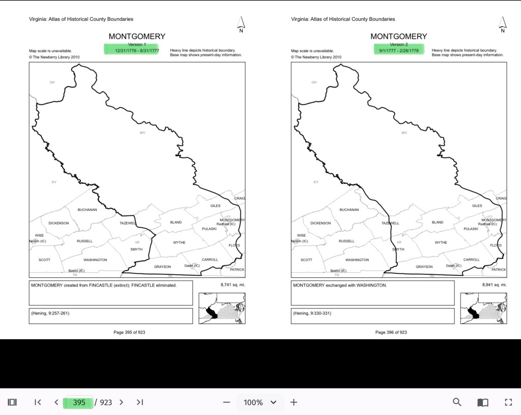
The flip book of maps below is a helpful resource to understand how the boundaries changed with time. Begin on page 395.
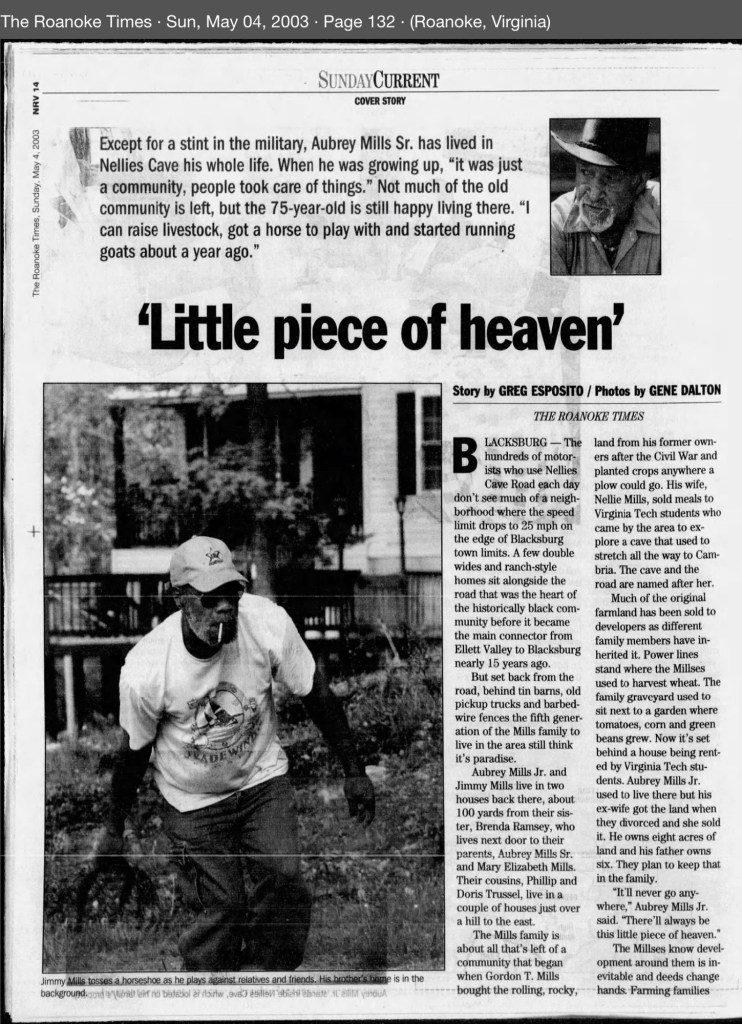
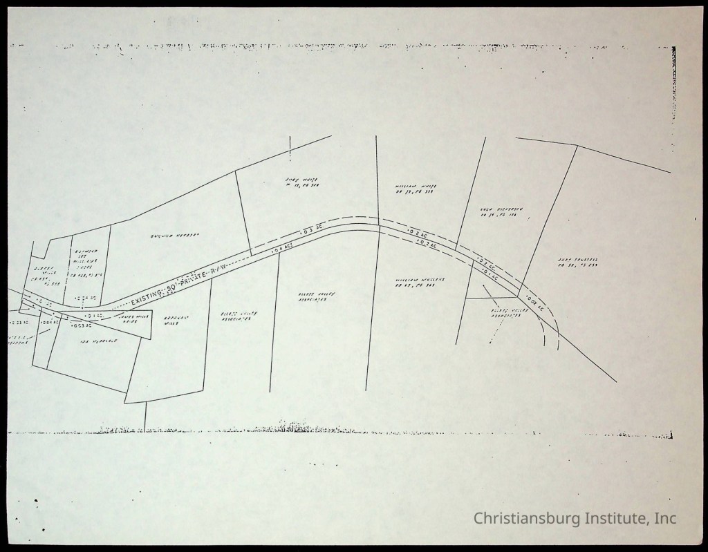
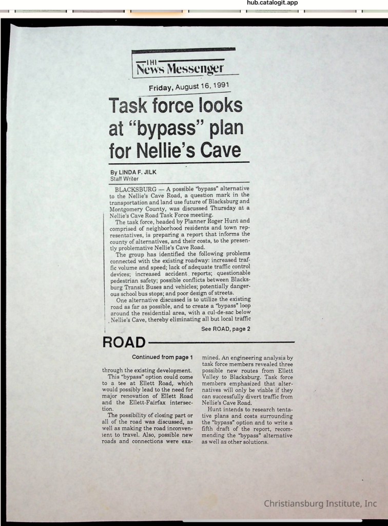
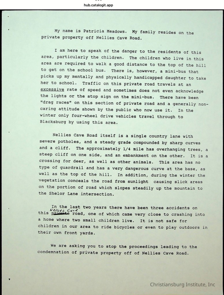
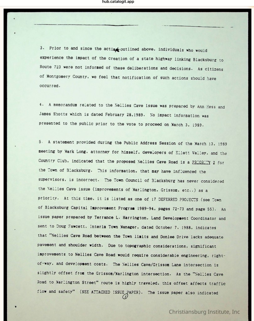
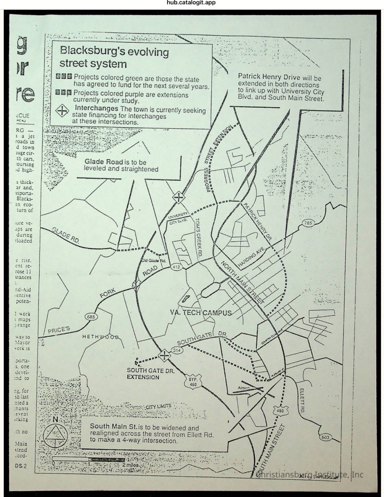
Southeast of the Town of Blacksburg, on the eastern side of the Allegheny Mountains, a community of African American families took root in the early 20th century when the Mills family purchased 40 acres from the Hoge family. For generations, these families farmed the land, raised children, and built their lives in this secluded karst landscape. The unpaved lane that served them was not called Nellie’s Cave Road until the 1980s, when Montgomery County officially named it. Before then, the residents knew it simply as Grissom Lane. The old farm road began at the Slusher family’s farm—located at the southeast corner of South Main Street and Country Club Drive—and ended where the terrain became too steep for a wagon to pass.